Ser du noget at forbedre? Foreslå en ændring.

Download Image Download Image of von Kármán Vortices Near the Cape Verde Islands
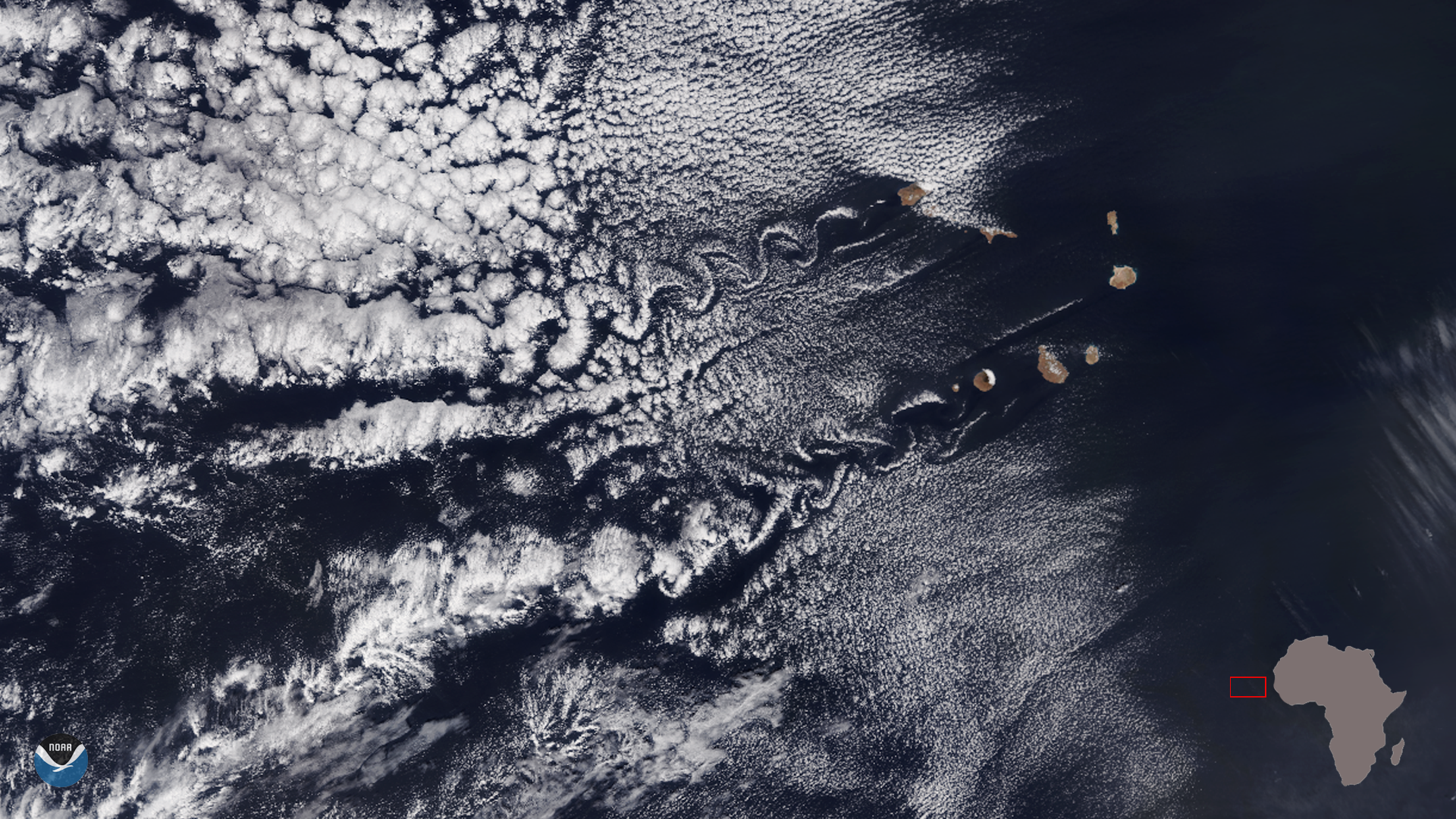
The NOAA-20 satellite captured this lovely image of a dual set of von Kármán vortices by the Cape Verde Islands (Republic of Cabo Verde) off the coast of West Africa on Jan. 9, 2020.
These long chains of spiral eddies are named after Theodore von Kármán, a Hungarian-American physicist, who was the first to describe how they form. The vortices can occur just about anywhere that fluid-- or in this case, atmospheric flow-- is disturbed by an object.
Here, wind-driven clouds blowing across the relatively flat expanse of water are diverted around a taller island, flowing around it in an alternating direction of rotation. Satellites help us see the resulting distinctive effect from above.
Some of the most common places in the world where this phenomenon occurs are where the Trade Winds are prevalent. These include the Canary Islands, Madeira Island, Cape Verde Islands, as well as Guadalupe and Socorro Islands west of Baja California and the Juan Fernandez Islands off the Chilean coast. They have also been spotted in the Greenland Sea, in the Arctic, and even next to a tropical storm. The world’s largest von Kármán vortices tend to form near the Hallasan Volcano on Jeju Island, off the coast of South Korea.

GOES East zoomed in on the von Kármán vortices streaming off the Cape Verde Islands on Jan 10, 2020.
The top image was captured by the NOAA-20 satellite's VIIRS instrument, which scans the entire Earth twice per day at a 750-meter resolution. Multiple visible and infrared channels allow it to detect atmospheric aerosols, such as dust, smoke and haze associated with industrial pollution and fires. The polar-orbiting satellite circles the globe 14 times daily and captures a complete daytime view of our planet once every 24 hours.
The animated loop was recorded by the GOES East geostationary satellite, also known as GOES-16, which keeps watch over most of North America, including the continental United States and Mexico, as well as Central and South America, the Caribbean, and the Atlantic Ocean to the west coast of Africa. The satellite's high-resolution imagery provides optimal viewing of severe weather events, including thunderstorms, tropical storms, and hurricanes.
Where this page came from
This page was imported from NOAA Satellites (NESDIS). Published by NOAA's National Environmental Satellite, Data, and Information Service and, as a work of the United States government, in the public domain; pictures credited elsewhere are left out.
Nobody has written it yet — it is the source material at a new address, which is why search engines are asked to skip it and why no one earns from it. It is up for grabs: take it on, and it is yours to rewrite and to earn from.
Licens: CC0 1.0 (offentligt eje) · Bearbejdet efter www.nesdis.noaa.gov
1
0
0
0

Kommentarer