
Want to improve the page's content? Try to propose a change.

Penstemon flowers blooming near Fajada Butte at Chaco Culture National Historical Park. NPS
Background
The Southern Colorado Plateau Inventory and Monitoring Network (SCPN) began monitoring grassland and shrubland systems in 2007 as part of an initiative to provide long-term, scientifically sound monitoring data to inform park management of natural resources. Specifically, SCPN collects data on the structure, abundance, species composition, and richness of upland vegetation, soil surface features, and soil stability.
Semi-arid grassland and shrublands comprise much of the vegetation in parks on the Southern Colorado Plateau. These vegetation communities are vitally important to the overall character of our regions parks, forming an integral component of the natural and cultural landscape.
In many SCPN parks, semi-arid grassland communities exist much as they may have prior to European expansion given their long history of protection from domestic grazing. Grasslands and shrublands provide important ecosystem services and are in decline globally. In SCPN parks, grasslands provide necessary habitat for birds, mammals, reptiles, and insects. Species growing and living in grasslands contribute to park diversity. Additionally, intact grassland vegetation stabilizes the soil which, critically, preserves and protects numerous paleontological and prehistoric resources and cultural relics.
Summary
This report presents results of upland vegetation and soil monitoring of semi-arid grasslands at three parks by SCPN from 2007–2021. The purpose is to compare and contrast five grassland ecological sites and examine how they have changed during the first 15 years of monitoring. Crews collected data on vegetation, both at the species level and by life-form (e.g., perennial grass, shrub, forb) soil stability, and soil texture at 150 plots within five target grassland/shrubland communities based on Natural Resource Conservation Service ecological site classification (30 plots per site).

SCPN Upland Vegetation field biologists hard at work measuring plots in Wupatki National Monument (2023). Christopher Calvo
Key Findings
- Warm season grasses are the dominant vegetation in these systems, and comprise most of the overall cover.
- Nonnative species were not common. The most common nonnatives species were Russian thistle and cheatgrass.
- Perennial grasses have decreased in a small but significant way in the last 15 years.
- Climate variables had mixed effects on vegetation, but drier and hotter spring seasons tended to decrease plant cover, while hot and dry July weather tended to increase it.
Soils in plots at Petrified Forest National Park (PEFO) and Chaco Culture National Historical Park (CHCU) were deeper than those at Wupatki National Monument (WUPA). Physical and rudimentary soil crust comprised the largest component of the soil surface, except at Wupatki where surface gravel dominated. Cover of biological soil crust (cyanobacteria, lichen, and moss) was low. Soil had moderate stability.
From 2007–2021, SCPN crews identified 283 unique plant species. Cover of live vegetation ranged from 12-24%.
Warm season grasses (C4 species) are adapted to grow under relatively warmer conditions compared to cool season grasses (C3 species) and made up more than 2/3 of vegetation in four of the five sites (>70% of total live foliar cover). Shrubs co-dominated at one site (WUPA L). Flowering plants (forbs) were an overall small component of total vegetation cover but contributed most of the diversity in these sites.
Less than 4% of species were nonnative. Russian thistle (Salsola tragus) was the most frequently sampled nonnative, occurring in > 50% of plots at Wupatki in the volcanic upland ecological site. Cheatgrass (Bromus tectorum) was the second most common nonnative species but occurred in < 10% of the plots at all ecological sites.

Snakeweed NPS
Changes over time (trend) were assessed using Bayesian hierarchical models that included year effects and site-specific covariates of seasonal water stress and topography. Models revealed significant decreases in cover in some modeled responses, most notably in the cover of perennial grass at all five sites (Fig. 1). Shrub and forb responses were mixed. Changes in richness, or the number of unique species identified per plot, differed by site, decreasing at the sandy loam site at CHCU but increasing in sandy loam at PEFO and in the volcanic site at WUPA (Fig. 1).

Figure 1. Summary of direction of year effects (trend) for plant cover. Green indicates a positive trend (increasing cover), red a negative trend, and a gray box indicates that the trend was non-significant. Non-colored boxes indicate plant trends were not modeled for the ecological site.
Plant cover was influenced by climate variables evaluated, but direction of these effects varied. The most consistent effects were that greater water stress in July (July deficit) and higher number of spring days with temperatures favorable to plant growth (Accumulated growing degree days or AGDD) increased cover of perennial grasses and shrubs during the same year (Fig. 2). However, greater water stress in the spring season (Spring deficit) had a negative effect on many responses (Fig 2).
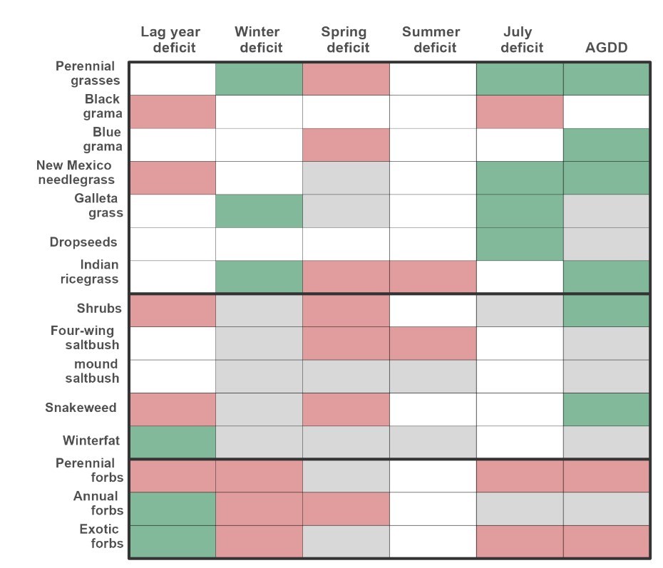
Figure 2. Summary of direction of climate variables effects on modeled responses. Green indicates a positive effect, red a negative effect and a gray box indicates that the effect was not significant. Non-colored boxes indicate that a given model did not include that covariate.
Reduced cover of perennial grass and increasing cover of shrubs and weedy forbs has been predicted for Southwestern grasslands in response to hotter and drier conditions due to human-caused climate change. Perennial grass trends reported here support those predictions. Continued drought conditions will likely worsen negative changes in these systems.
Management Implications
The negative trend in grass cover and few nonnative species, highlights the importance of limiting disturbance in these areas, including livestock trespassing and road or trail building.
Maintaining these sites to prevent further decline coupled with thoughtful restoration tactics will help to support a stable ecosystem in the face of human-caused climate change.

Mariposa lilies and milkvetch blooming near Crystal Forest at Petrified Forest National Park. Hallie Larsen
Full Report or printable version of this brief
Contact Megan Swan for more information
Prepared by Christopher Calvo (January 2024)
Where this belongs
- Chaco Culture National Historical Park
- Petrified Forest National Park
- Wupatki National Monument
Where this page came from
This page was imported from National Park Service. Produced by the U.S. National Park Service and, as a work of the United States government, in the public domain.
Nobody has written it yet — it is the source material at a new address, which is why search engines are asked to skip it and why no one earns from it. It is up for grabs: take it on, and it is yours to rewrite and to earn from.
In these collectionsChaco Culture National Historical ParkPetrified Forest National ParkWupatki National Monument
Licence: CC0 1.0 (public domain) · Adapted from www.nps.gov
1
0
0
0

Comments
Read next


