Есть что улучшить? Предложите правку.
Overview of Cape Verde baseline groundwater study
Why was the study done?
Groundwater resources in Cape Verde provide water for agriculture, industry, and human consumption. These resources are limited and susceptible to contamination. Additional groundwater resources are needed for continued agricultural development, particularly during times of drought, but increased use and (or) climatic change may have adverse effects on the quantity and quality of freshwater available. In volcanic island aquifers such as those of Cape Verde, a lens of fresh groundwater typically “floats” upon a layer of brackish water at the freshwater/saltwater boundary, and increased pumping may cause salt water intrusion or other contamination. A recent U.S. Geological Survey study (Heilweil and others, 2006, 2009) assessed baseline groundwater conditions in watersheds on three islands of Cape Verde to provide the scientific basis for sustainably developing water resources and minimizing future groundwater depletion and contamination.
Setting and approach
Cape Verde is an archipelago of nine inhabited islands located about 750 kilometers off the west coast of Africa (fig. 1). Three watersheds were studied for the baseline groundwater study: Ribeira Fajã Basin on São Nicolau (this fact sheet), Mosteiros Basin on Fogo (Heilweil and others, 2010a), and Ribeira Paúl Basin on Santo Antão (Heilweil and others, 2010b). Rainfall in Cape Verde varies greatly from year to year and with elevation. Average annual rainfall ranges from less than 50 millimeters along the populated coastal areas up to 1,000 millimeters in the highlands. Most of the population resides in rural areas and derives its livelihood from rain-fed
Coastal Coastal West Africa West Africa
agriculture; the irregular rainfall makes farming extremely challenging in all but the wettest areas (Haagsma, 1995).
Very few streams are perennial because most rainfall rapidly runs to the ocean, evaporates, or is used by plants, with the remainder infiltrating through permeable rock to recharge the underlying aquifers. The groundwater moves downgradient from the upper elevations to the lower parts of each watershed, where it discharges to wells, springs, streams, tunnels, and to the ocean as submarine discharge (fig. 2). To assess groundwater resources in each basin, data were collected at many of these discharge points. The resulting groundwater levels, flow measurements, and water chemistry analyses were used to assess groundwater budgets, recharge sources, travel times, vulnerability to contamination, and sustainability of pumping.

Figure 2. Generalized conceptual model of volcanic island hydrology.
Ribeira Fajã Basin, São Nicolau
Results – What was learned?
Ribeira Fajã (16 square kilometers)is the lowest and driest of the three study basins, having an average altitude of 480 meters and an estimated average annual rainfall of about 300 millimeters. Annual rainfall at the Cachaço precipitation station (fig. 3) varies from as little as 100 to almost 700 millimeters. Ribeira Fajã has no measurable natural groundwater discharge to springs or streams. Historically, there were springs in the lower part of the basin, but these dried up as a consequence of the completion of the Galleria Fajã tunnel in 1985. Groundwater drainage associated with this tunnel also caused water levels to decline 20 meters or more in nearby wells, two of which subsequently dried up. Discharge from the completed tunnel is now the only source of groundwater in the basin, but it has declined from an initial daily flow of 1,400 cubic meters to about 400 cubic meters in recent years. This decline was caused by aquifer de-watering associated with the tunnel rather than changes in rainfall (fig. 4). Based on this discharge amount, only about 3 percent of rainfall in the basin recharges the groundwater system, but this percentage may be higher if submarine discharge of groundwater is occurring off the coast of Ribeira Fajã.

Figure 3. Hydrologic map of Ribera Fajã Basin, Island of São Nicolau.
Environmental tracers sampled in one well and three locations in the Galleria Fajã tunnel indicate that the groundwater in Ribeira Fajã Basin is older than 50 years. This is consistent with the lower rainfall and groundwater discharge than in the other
Ribeira Fajã Basin São Nicolau
two study basins, which have younger groundwater. Because of less precipitation and lower recharge, along with deeper groundwater levels, the groundwater system in Ribeira Fajã may not be as susceptible to contamination from agriculture and (or) septic systems as in the other basin. The quality of groundwater within the basin is generally very good. Less recharge in this basin than in the other two study basins, however, indicates that the lower part of the basin may be susceptible to saltwater intrusion due to well pumping.
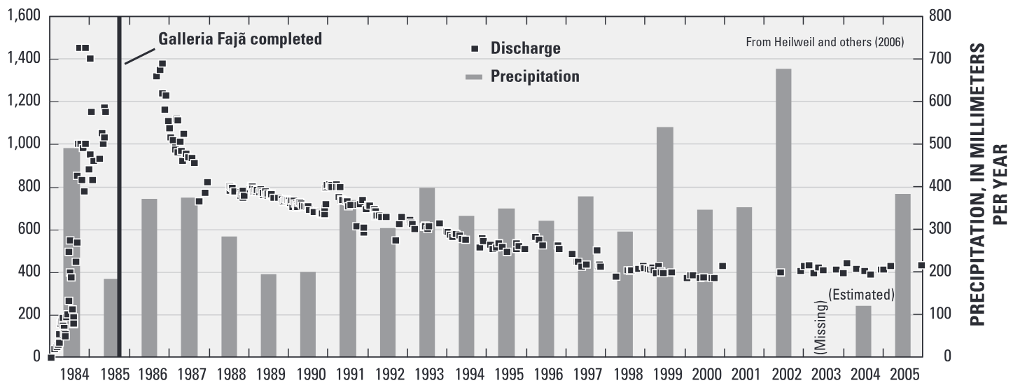
Figure 4. Graph showing discharge from the Galleria Fajã tunnel and rainfall in Ribeira Fajã Basin.
Challenges for future water-resources development and management in Ribeira Fajã Basin
- Groundwater resources in Ribeira Fajã Basin are limited in comparison to other watersheds in Cape Verde that have higher precipitation and infiltration.
- The completion of the Galleria Fajã tunnel in 1985 provided an additional source of water in the basin, but caused groundwater levels to decline rapidly and nearby wells and springs to dry up.
- Recharge enhancement (artificial recharge) in the basin is a possible mechanism for replenishing groundwater storage, but must take into account permeability of surficial soils and underlying bedrock.
- The quality of groundwater within the basin is generally very good and no wells are currently being pumped. To minimize
Additional resources
the risk of saltwater intrusion, however, future groundwater development near the coast should be limited.
- Because of water-quality and water-quantity concerns in Ribeira Fajã Basin, careful stewardship and management practices will be essential for protecting water resources for future generations.
By frequently monitoring discharge from the Galleria Fajã tunnel, rainfall, water-level changes, groundwater chemistry (salinity and nitrates), and possible future well pumping, scientifically based metrics can be established to ensure sustainable future groundwater and agricultural development in Ribeira Fajã Basin.
Acknowledgements
The USGS thanks the Millennium Challenge Account – Cape Verde, the Instituto Nacional de Gestão dos Recursos Hídricos, and local water management agencies in Mosteiros, Ribeira Paúl and Ribeira Fajã, for providing historical information and assistance with hydrologic data collection and interpretation.
Where this page came from
This page was imported from U.S. Geological Survey. Published by the U.S. Geological Survey and, as a work of the United States government, in the public domain.
Nobody has written it yet — it is the source material at a new address, which is why search engines are asked to skip it and why no one earns from it. It is up for grabs: take it on, and it is yours to rewrite and to earn from.
Лицензия: CC0 1.0 (общественное достояние) · По материалам pubs.usgs.gov
1
0
0
0

Комментарии