Ser du noget at forbedre? Foreslå en ændring.
Prepared in cooperation with the U.S. Department of Agriculture Natural Resources Conservation Service and the Rhode Island Water Resources Board
Front cover: Wood River at Hope Valley, Rhode Island. Photo by Peter Flinker, Dodson Associates, Ltd.
By Robert F. Breault, Phillip J. Zarriello, Gardner C. Bent, John P. Masterson, Gregory E. Granato, J. Eric Scherer, and Kathleen M. Crawley
Prepared in cooperation with the U.S. Department of Agriculture Natural Resources Conservation Service and the Rhode Island Water Resources Board KEN SALAZAR, Secretary
U.S. Geological Survey, Reston, Virginia: 2009
Abstract ...........................................................................................................................................................1 Introduction.....................................................................................................................................................2 Water Resources ..................................................................................................................................4 Water Use .............................................................................................................................................6 Assessment of Water-Management Strategies .......................................................................................6 Effects of Current Water Use on Streamflow...................................................................................6 Effects on Streamflow of Replacing Surface-Water Withdrawals with Groundwater
Effects of Groundwater Pumping on the Water Table ..................................................................13 Effects of Potential Changes in Land Use and Water Use ...........................................................14 Summary........................................................................................................................................................16 References Cited..........................................................................................................................................16
Figures
- Map showing Pawcatuck River Basin, southwestern Rhode Island and
- Graphs showing monthly precipitation measured at the University of Rhode Island
- Graphs showing flow paths of precipitation to a stream under (A) natural conditions,
- Graphs showing average monthly water use in the Pawcatuck River Basin during
- Graphs showing hourly streamflow simulated in August 2002 for the (A) upper
- Schematic diagram of groundwater withdrawals from different well locations
- Graph showing simulated effects of irrigation withdrawals on streamflow as the well
- Map showing simulated water-management strategy that replaces six instream
- Graph showing simulated streamflow changes that result from replacing six instream
- Map showing groundwater-model simulated changes in water levels in the Diamond
- Maps showing representation of the simplified land use in the Pawcatuck River iii
and daily mean streamflow measured at the Pawcatuck River at Westerly (USGS station 01118500) during 2000–04 ...............................................................................................4
(B) intercepted groundwater by a pumped well, and (C) induced infiltration by a pumped well ..................................................................................................................................5
2000–04 for (A) public supply and (B) irrigation .......................................................................6
Pawcatuck River, (B) lower Chipuxet River, (C) Usquepaug River, and (D) lower Beaver River under no withdrawals, current (2000–04) withdrawals, and current withdrawals with selected instream irrigation withdrawals replaced by groundwater withdrawals ...........................................................................................................8
between the relatively large Wood River and the smaller Meadow Brook ........................9
distance from a stream increases; the effects on streamflow are damped and spread out over time as the distance of the well from the stream increases ...............................10
irrigation withdrawals with groundwater withdrawals between the lower Beaver and Usquepaug Rivers.......................................................................................................................11
irrigation withdrawals in the lower Beaver and Usquepaug Rivers with groundwater withdrawals between the rivers ..............................................................................................12
Bog area in the Wood River subbasin for March 2000 and March 2002 ...........................13
Basin simulated by the Hydrologic Simulation Program–FORTRAN model under 1995 conditions and projected buildout conditions .......................................................................15 iv
Conversion Factors and Datums
Flow rate in Mgal/d or ft/s can be converted by: Mgal/d1.547 = ft/s or ft/s0.6463 = Mgal/d.
By Robert F. Breault, Phillip J. Zarriello, Gardner C. Bent, John P. Masterson, Gregory E. Granato, J. Eric Scherer, and Kathleen M. Crawley
Abstract
The Pawcatuck River Basin in southwestern Rhode Island and southeastern Connecticut is an important high-quality water resource for domestic and public supplies, irrigation, recreation, and the aquatic ecosystem. Concerns about the effects of water withdrawals on aquatic habitat in the basin have prompted local, State, and Federal agencies to explore water-management strategies that minimize the effects of withdrawals on the aquatic habitat. As part of this process, the U.S. Geological Survey in cooperation with the U.S. Department of Agriculture Natural Resources Conservation Service and the Rhode Island Water Resources Board completed a study to assess the effects of current (2000–04) and potential water withdrawals on streamflows and groundwater levels using hydrologic simulation models developed for the basin. The major findings of the model simulations are:
Moving highly variable seasonal irrigation withdrawals from streams to groundwater wells away from streams reduces short-term fluctuations in streamflow and increases streamflow in the summer when flows are lowest. This occurs because of the inherent time lag between when water is withdrawn from the aquifer and when it affects streamflow.
A pumped well in the vicinity of small streams indicates that if withdrawals exceed available streamflow, groundwater levels drop substantially as a consequence of water lost from aquifer storage, which may reduce the time wetlands and vernal pools are saturated, affecting the animal and plant life that depend on these habitats.
The effects of pumping on water resources such as ponds, streams, and wetlands can be minimized by relocating pumping wells, implementing seasonal pumping schemes that utilize different wells and pumping rates, or both.
The effects of projected land-use change, mostly from forest to low- and medium-density housing, indicate only minor changes in streamflow at the subbasin scale examined; however, at a local scale, high flows could increase, and low flows could decrease as a result of increased impervious area. In some instances, low flows could increase slightly as a result of decreased evapotranspiration from the loss of deeprooted vegetation (forest) associated with development.
In some subbasins where large areas of agricultural lands were converted to low- and medium-density housing, low flows increase because the consumptive domestic water use was projected to be less than consumptive agricultural water use. All agricultural water use was for irrigation purposes and was assumed to be lost from the basin through evapotranspiration.
Water-Management Strategies on Water Resources in the Pawcatuck River Basin, Rhode Island and Connecticut
Introduction
The Pawcatuck River Basin in southwestern Rhode Island and southeastern Connecticut is known for its biologically diverse aquatic habitat and its yield of high-quality water that is used for a variety of purposes (fig. 1). Nearly two-thirds of the State’s rare and unique natural communities can be found within this basin. Water resources are also important for irrigation, domestic and public water supply, recreation, and the scenic beauty of the basin. The primary water use is for municipal supply, with withdrawals mainly in the eastern and southwestern parts of the basin, but seasonal irrigation is also a major water use in parts of the basin.
In 2005, the U.S. Environmental Protection Agency reported that the Pawcatuck River Basin had the highest concentration of turf farms in the Nation. These farms are irrigated mostly in the summer when streamflows and groundwater levels are typically at their lowest. Streamflow data indicate that irrigation withdrawals from streams appreciably decrease summer low flows. Future groundwater withdrawals, mainly by municipal suppliers, are also of concern because of their potential effects on streamflows and groundwater levels.
In response to these concerns, the U.S. Department of Agriculture Natural Resources Conservation Service (NRCS) and the Rhode Island Water Resources Board (RIWRB) began a cooperative study with the U.S. Geological Survey (USGS) in 2002 to evaluate the water resources of the basin, the hydrologic effects of water use, water-management alternatives, and potential hydrologic changes that might result from future land-use and water-use changes. The results of this investigation will assist the NRCS, the RIWRB and other State agencies, and local communities in understanding how streamflows and water levels are affected by current water-use practices, and how these practices may be modified to meet water-supply needs while also meeting recreation and aquatic-life needs.
This report describes the major findings of that study, in particular, the potential effects of water-management strategies on streamflows and water levels in the Pawcatuck River Basin. Additional information about the study and its findings can be found in the U.S. Geological Survey Scientific Investigations Report 2010– 5127 (Bent and others, in press).
Introduction
Water-Management Strategies on Water Resources in the Pawcatuck River Basin, Rhode Island and Connecticut
The Pawcatuck River Basin (fig. 1) covers an area of about 303 mi that includes the Wood River (89.2 mi), Usquepaug-Queen River (36.6 mi), Ashaway River (28.2 mi), Chipuxet River (17.3 mi), Shunock River (16.3 mi), Beaver River (12.5 mi), Meadow Brook (7.21 mi), and Chickasheen Brook (6.55 mi). The surficial geology of the basin is mainly glacial stratified deposits of sand, gravel, silt, and clay along the major river valleys and glacial till or exposed bedrock in the upland areas, with the Charlestown moraine, a mostly sand and gravel glacial deposit, forming the southern border of the basin (fig. 1). Postglacial deposits consisting of flood-plain alluvium along rivers and streams, organic peat, and muck (swamp deposits) are present in some areas. Thick (100 to 200 ft) deposits of valley-fill sand and gravel compose the major aquifers in the basin and are the primary source of public water supply. The basin is designated as a sole source aquifer by the U.S. Environmental Protection Agency (Federal Register, 1988).
All water for public supply, irrigation, and streamflow in the basin originates from precipitation. Annual precipitation is, on average, about 52 in/yr (or, on average, about 4.3 in/month) at the University of Rhode Island climatological station (fig. 1 and 2). If all precipitation left the basin as streamflow this would equal about 1,160 ft/s; however, mean daily flow at the USGS streamgage near the mouth of the Pawcatuck River at Westerly, RI (01118500; fig. 1) is about 580 ft/s (fig. 2), or about 50 percent of the average annual precipitation in the basin. The remaining 50 percent of the precipitation leaves the basin by a combination of evaporation, plant transpiration, and withdrawals that are transferred out of the basin.
The precipitation that eventually discharges to streams follows complex flow paths across and through the landscape. These flow paths are categorized simply as surface runoff; shallow subsurface flow referred to as interflow; and deeper subsurface flow that provides recharge to the aquifer and eventually discharges to streams as baseflow (fig. 3A).
Introduction
The amount of water that moves along each of these flow paths is governed by soils, surficial geology, imperviousness, slope, and other factors that influence the hydrologic response to precipitation. During low-flow periods, baseflow is often the only component of streamflow.
Groundwater withdrawals can affect streamflow in several ways. A pumped well that captures groundwater that would otherwise discharge to streams (fig. 3B) ultimately decreases streamflow in proportion to the withdrawal. If groundwater withdrawals are large enough that the water level in the stream is greater than the water level in the underlying aquifer, water seeps from the stream into the aquifer (induced infiltration) and could become a direct source of water to the pumped well (fig. 3C). If the pumping rate exceeds the rate of streamflow or the rate of induced infiltration, the difference between the two comes from water stored in the aquifer. As more water is removed from aquifer storage, drawdown increases as does the area of influence of the pumped well; these conditions are important in assessing the effects of pumping on nearby surface-water features, such as ponds, wetlands, and vernal pools.
Regardless of whether groundwater pumping results in captured baseflow or induced infiltration from the stream, the streamflow is reduced in direct proportion to the pumping rate when the pumping rate is constant and water is not removed from aquifer storage. If the pumping rate varies, however, as is typical of irrigation withdrawals, there is a time lag between the change in the withdrawal rate and the rate of streamflow depletion that is largely controlled by the aquifer properties and the distance of the pumped well from the stream. Managing the effects of groundwater withdrawals on streamflow and other hydrologic features requires a quantitative understanding of this lag effect, which can be represented in simulation models to determine optimal well locations and pumping rates to minimize the effects of pumping on streamflows during critical low-flow periods.

Figure 3. Flow paths of precipitation to a stream under (A) natural conditions, (B) intercepted groundwater by a pumped well, and (C) induced infiltration by a pumped well. A pumped well captures groundwater that would otherwise discharge to a stream, induces infiltration from the stream, or both; if the rate of withdrawal exceeds the rate of streamflow, induced infiltration can cause the stream to stop flowing.
Water-Management Strategies on Water Resources in the Pawcatuck River Basin, Rhode Island and Connecticut
Water Use
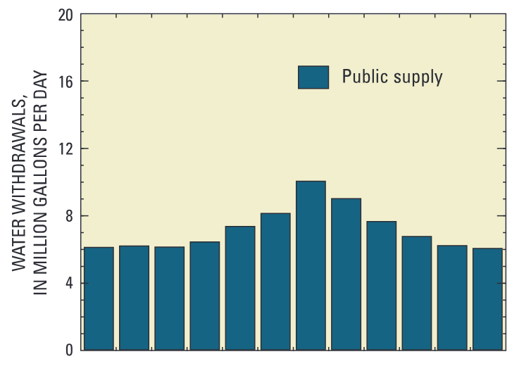
The primary uses of water in the basin are public supply and irrigation. Public supply is exclusively derived from groundwater, whereas water for irrigation, at present, is primarily withdrawn from surface-water sources. Water withdrawals from the five major municipal suppliers averaged about 7 Mgal/d for the 2000–04 period, with a maximum average monthly pumping rate of 10 Mgal/d in July (fig. 4A). Although these withdrawals vary over the year, the public-supply withdrawals are more evenly distributed than irrigation withdrawals, which typically begin in May, peak in July, and end in October (fig. 4B), but are are still highly variable during this time depending on weather conditions. Measured and estimated irrigation withdrawals during 2000–04 over this six-month period averaged about 4 Mgal/d, with a maximum monthly rate of about 8 Mgal/d in July. Irrigation withdrawals are primarily for turf farms and golf courses. Additional information about water use in the basin can be found in Bent and others (in press) and Wild and Nimiroski (2004).
Assessment of Water-Management Strategies
Simulation models (see sidebar to the right) were developed to assess basinwide and local-scale water-management strategies, including evaluation of the effects on streamflow under:
- current (2000–04) water withdrawals,
- replacing irrigation surface-water withdrawals with groundwater withdrawals, and

Figure 4. Average monthly water use in the Pawcatuck River Basin during 2000–04 for (A) public supply and (B) irrigation. Water use varies over the year, but the public-supply withdrawals are more evenly distributed than the irrigation withdrawals, which occur mostly during the summer.
- potential changes in land use and water use.
Effects of Current Water Use on Streamflow
The precipitation-runoff model HSPF (Hydrologic Simulation Program–FORTRAN by Bicknell and others, 2000) was developed for the entire basin to evaluate the effects of average 2000–04 water withdrawals on streamflows over longterm climatic conditions (1960–04). The model simulations focused on river reaches in 12 subbasins that were of greatest interest to the project Technical Advisory Committee (TAC) because of withdrawals and ecological importance. Simulation of flow alteration by current withdrawals (2000–04) and alternative withdrawals were compared to simulations of flows with no withdrawals in each of the focus subbasins. The results indicate that streamflow in the upper Pawcatuck River above the confluence with the Usquepaug River and in the lower Chipuxet River, followed by the Usquepaug River and lower Beaver
PRECIPITATION-RUNOFF MODEL
The precipitation-runoff model HSPF (Hydrologic Simulation Program– FORTRAN by Bicknell and others, 2000), was developed for the entire basin for evaluating current and alternative water-management strategies and the effects of potential land-use and water-use change on streamflow. The simulation results focused on 12 subbasins highlighted. The models developed can simulate a wide range of conditions, but modifications to the model structure may be required to represent other potential conditions. As for all models, consideration of inherent limitations and uncertainties of the models should be given to the interpretation of the simulation results.
Assessment of Water-Management Strategies
GROUNDWATER MODELS The USGS groundwater flow model (MODFLOW, Harbaugh and others, 2000) was developed for two subregions—the lower Wood River and the eastern Pawcatuck River—to further evaluate current and alternative water-management strategies on streamflow and groundwater levels.

Figure 5. Hourly streamflow simulated in August 2002 for the (A) upper Pawcatuck River, (B) lower Chipuxet River, (C) Usquepaug River, and (D) lower Beaver River under no withdrawals (black line), current (2000–04) withdrawals (red line), and current withdrawals with selected instream irrigation withdrawals replaced by groundwater withdrawals (green line). Subbasins are shown on the precipitation-runoff model sidebar.
Assessment of Water-Management Strategies
River, are most affected by withdrawals compared to the other reaches. During August 2002, the driest month during the 2000–04 data-collection period, withdrawals decreased streamflow in the upper Pawcatuck and lower Chipuxet Rivers by about 70 percent (fig. 5A and B, respectively), by about 19 percent in the Usquepaug River (fig. 5C), and by about 34 percent in the lower Beaver River (fig. 5D). Streamflows in the upper Pawcatuck River were affected mainly by municipal water-supply withdrawals, the lower Chipuxet River was affected by both irrigation and municipal-supply withdrawals, and the Usquepaug River and lower Beaver River were affected by irrigation withdrawals. All water for municipal and irrigation withdrawals was assumed lost from the basin through out-of-basin transfers and evapotranspiration, respectively. HSPF simulations also indicate that moving irrigation withdrawals out of rivers to groundwater sources appreciably damped intradaily flow fluctuations (fig. 5B, C, and D).
Effects on Streamflow of Replacing Surface-Water Withdrawals with Groundwater Withdrawals
The groundwater-flow model MODFLOW (Harbaugh and others, 2000) was developed for the lower Wood and the eastern Pawcatuck River model areas (sidebar) to further analyze the interaction between groundwater and surface water in the basin. The lower Wood River model was used to simulate several hypothetical well locations between the Wood River and Meadow Brook to illustrate the effects of pumping on large and small rivers; the model was also used to evaluate groundwater level changes by a hypothetical well in Diamond Bog area. The eastern Pawcatuck River model focused on changes in baseflow caused by replacing instream withdrawals with groundwater wells away from streams.
The streamflow response to pumping from a nearby well depends on the distance of the well from the stream and the flow in the stream— pumping a well close to the Wood River (well A; fig. 6) decreases streamflow in the Wood River more than pumping a well farther from the river (well B); but conversely, pumping well B decreases flow in Meadow Brook more than pumping well A. The steady-state simulation of well A,

Figure 6. Schematic diagram of groundwater withdrawals from different well locations between the relatively large Wood River and the smaller Meadow Brook. If well A is pumped, about 90 percent of the water comes from baseflow to or induced infiltration from the Wood River with the remaining 10 percent coming from baseflow to or induced infiltration from Meadow Brook; if well B is pumped, about 67 percent of the water comes from baseflow to or induced infiltration from the Wood River with the remaining 33 percent from baseflow to or induced infiltration from Meadow Brook.
Water-Management Strategies on Water Resources in the Pawcatuck River Basin, Rhode Island and Connecticut
about 20 percent of the distance from the Wood River to Meadow Brook, indicates that most of the pumped water (about 90 percent) comes from baseflow to or induced infiltration from the Wood River, and the remaining 10 percent comes from baseflow to or induced infiltration from Meadow Brook. The steady-state simulation of well B, about equally far from the Wood River and Meadow Brook, indicates that about 67 percent of the water pumped comes from baseflow to or induced infiltration from the Wood River and the remaining 33 percent comes from baseflow to or induced infiltration from Meadow Brook.
This example shows how moving the location of a pumped well changes the flow in Wood River and Meadow Brook, but another important consideration is the relation between the rate of pumping and the rate of streamflow. Streamflow near the hypothetical wells during 2000–04 averaged about 180 ft/s in the Wood River and about 10 ft/s in Meadow Brook. As a result, if well A were pumped at 1.0 Mgal/d (about 1.6 ft/s), the mean daily flow in the Wood River would decrease by less than one percent; however, if well B were pumped at the same rate, the mean daily flow in Meadow Brook would decrease by about 5 percent. During low-flow periods, the same pumping rate would have a much greater effect on streamflow because the ratio of withdrawals to streamflow would be much larger. For example, during August 2002, streamflow near the hypothetical wells averaged about 16 ft/s in the Wood River and about 0.2 ft/s in Meadow Brook. Thus, if well A is pumped at 1.0 Mgal/d, streamflow in the Wood River would decrease by about 9 percent; however, if well B were pumped at the same rate, Meadow Brook would stop flowing.
The previous example focused on the effects of pumping continuously at a constant rate, which would more likely be used for public-supply withdrawals than for irrigation withdrawals, which are highly dependent on weather conditions. During the 2000–04 period, most of the irrigation water used in the basin was obtained directly from streams and, as is true of most irrigation withdrawals, demand was high when streamflows were low. To reduce the effects of pumping water directly from streams, the NRCS sought information on the effects of replacing instream withdrawals with groundwater withdrawals from wells moved away from streams.

Figure 7. Simulated effects of irrigation withdrawals on streamflow as the well distance from a stream increases; the effects on streamflow are damped and spread out over time as the distance of the well from the stream increases. Daily mean withdrawal data from figure 27, Zarriello and Bent, 2004.
Assessment of Water-Management Strategies
Simulations indicate that replacing instream irrigation withdrawals with groundwater withdrawals from wells moved away from the streams alters the timing and magnitude of the pumping effects on streamflow. Instream withdrawals have an instantaneous effect on streamflow equal to the pumping rate. On the other hand, the response of streamflow to groundwater withdrawals is damped as the well is moved farther from the stream (fig. 7). It should be noted that, although the effects of withdrawals on streamflow are damped, streamflow is still reduced by the amount of water pumped; however, for highly variable irrigation withdrawals, the damped streamflow response typically mitigates the instantaneous effects of direct surface-water withdrawals (fig. 7).
The relocation of instream pumps to groundwater wells could appreciably improve low flows in the lower Beaver and Usquepaug Rivers because irrigation withdrawals in this area are large relative to typical summer streamflows. Six instream withdrawals, five from the Beaver River and one from the Usquepaug River, were replaced by six hypothetical well withdrawals placed between these rivers (fig. 8). Groundwater-model simulations indicate that baseflow increased by about 1.3 ft/s during July to September of 2002 in both the lower Beaver and Usquepaug Rivers and decreased during the fall months relative to direct surface-water
r
t

Figure 8. Simulated water-management strategy that replaces six instream irrigation withdrawals (orange hexagons) with groundwater withdrawals (yellow dots) between the lower Beaver and Usquepaug Rivers.
Water-Management Strategies on Water Resources in the Pawcatuck River Basin, Rhode Island and Connecticut Assessment of Water-Management Strategies

Figure 9. Simulated streamflow changes that result from replacing six instream irrigation withdrawals in the lower Beaver and Usquepaug Rivers with groundwater withdrawals between the rivers (locations shown on fig. 8). Groundwater withdrawals increased summer low flows compared with instream irrigation withdrawals because of the delayed effect of pumping on streamflow. During August 2002, streamflows increased by about 43 and 9 percent in the Beaver and Usquepaug Rivers, respectively.
withdrawals (fig. 9). Although the increase in summer baseflow was similar, the percent change in flow was determined by the amount of baseflow simulated in the rivers, which during August 2002 averaged about 3.0 and 14 ft/s in the Beaver and Usquepaug Rivers, respectively. Thus, a 1.3 ft/s increase in flow during this period is equivalent to a 43- and a 9-percent increase in flow in the Beaver and Usquepaug Rivers, respectively. The benefit of shifting withdrawals to groundwater is that, by the fall, streamflows are typically increasing and the effects of pumping represent a smaller fraction of the total streamflow in the fall compared to the summer.
Effects of Groundwater Pumping on the Water Table
Relocating instream withdrawals to groundwater withdrawals typically increase summer low flows as shown; however, pumping from groundwater also lowers the water table, which can adversely affect nearby surface waters such as ponds and wetlands. For this reason groundwater-model simulations were also used to evaluate the effects of withdrawals on the water table in the Diamond Bog area, one of the most ecologically sensitive habitats in Rhode Island (Colin Apse, The Nature Conservancy, written Diamond Bog commun., 2005). Simulations indicate that during area a normal spring (March 2000) a hypothetical well pumped at 1 Mgal/d lowered the water table by less than 0.5 ft, but during the relatively dry spring of March 2002, the same well pumped at the same rate extended the 0.5-ft drawdown contour beyond the Diamond Bog area (fig. 10). The reason for this difference is attributed to the flow in Diamond Brook; when flowing, the brook EXPLANATION is a source of water to the well through induced infiltration. When the brook is dry, the water that flows to the well is from groundwater storage and the water table is lowered. This example shows that under certain conditions the hydroperiod, the length of time that wetlands and vernal pools are wet, can be reduced, and thus can affect aquatic communities that depend on these resources.
Water-Management Strategies on Water Resources in the Pawcatuck River Basin, Rhode Island and Connecticut
Effects of Potential Changes in Land Use and Water Use
Changes in streamflow that could result from land-use change and associated water-use change under potential buildout conditions were evaluated by HSPF simulations of the effects of (1) land-use change only, (2) water-use change only, and (3) the combined effects of land- and water-use change. Land-use change was determined mostly on the basis of a statewide map of potential buildout that was compiled under the provisions outlined in the Rhode Island Comprehensive Planning and Regulation Act of 1988. In 1995, about 10 percent of the basin was classified as developed, but the potential buildout indicates that as much as 50 percent of the basin could be developed in the future (fig. 11). This buildout analysis assumed that lands not already developed nor protected from development, including irrigated lands with the exception of golf courses, were developable. Simulated buildout changes include the following:
- The largest land-use change was from forest to lowto-medium-density residential development;
- Total public and self-supplied water use in the basin at buildout was estimated at 22 Mgal/d, or about four times the water use reported for 1995–99 (Wild and Nimiroski, 2004), but 80 percent of this new demand was assumed to be returned to the basin through on-site septic disposal; and
- Total commercial and industrial water use in the basin at buildout was estimated at about 7.5 Mgal/d, or six times the reported 1995–99 commercial and industrial water use (Wild and Nimiroski, 2004), but most (80 percent) was also returned through on-site septic disposal. In general, simulations indicate that high flows would
increase slightly because of increased impervious area under buildout conditions compared to 1995 land-use conditions; as impervious area increases, more precipitation flows to streams as surface runoff that flows at a faster rate to streams than subsurface-flow components. For the same reasons, the simulations indicate that low flows decrease slightly because less rainfall infiltrates into the soil; as a result, recharge to the aquifer and the baseflow contribution to streams decrease. In some streams, low flows may increase slightly because the net domestic consumptive use at buildout is less than current consumptive irrigation water use, or because the decreased infiltration due to increased impervious area at buildout is more than offset by decreased evapotranspiration losses resulting from the removal of trees associated with development, or both.
Assessment of Water-Management Strategies Water-Management Strategies on Water Resources in the Pawcatuck River Basin, Rhode Island and Connecticut

Figure 11. Representation of the simplified land use in the Pawcatuck River Basin simulated by the Hydrologic Simulation Program–FORTRAN model under 1995 conditions and projected buildout conditions.
Summary
The Pawcatuck River Basin in southwestern Rhode Island and southeastern Connecticut is known for its high-quality water resources and its biologically diverse aquatic ecosystems. Water from the basin is used primarily for public supply and irrigation. Concerns about the effects of water withdrawals prompted a cooperative investigation in 2002 by the U.S. Geological Survey, the Natural Resources Conservation Service, and the Rhode Island Water Resources Board, to improve the understanding of water resources of the Pawcatuck River Basin and to assess the hydrologic effects of potential water-management strategies. As part of this study, a precipitation-runoff model (HSPF) was developed for the entire basin, and two groundwater models (MODFLOW) were developed for subareas of the basin. The results of the model simulations quantified the effects on streamflow of existing water withdrawals, which can be large in some parts of the basin, but also showed that alternative water-management strategies, such as replacing instream irrigation withdrawals with groundwater withdrawals away from streams, may reduce the effect of withdrawals on low flows. The benefits are shown to be site specific, but the modeling tools developed to simulate the hydrology of the Pawcatuck River Basin can be used to analyze other possible site-specific management practices. For example, if a new commercial, industrial, agricultural, or municipal water supply is needed, the tools developed here could be used to identify optimal groundwater-well locations, assess the effects of withdrawals on streamflows and groundwater levels, and determine the best pumping schemes to minimize effects of withdrawals.
References Cited
Bent, G.C., Zarriello, P.J., Granato, G.E., Masterson, J.P., Walter, D.A., Waite, A.M., and Church, P.E., in press, Simulated effects of water withdrawals and land-use changes on streamflows and groundwater levels in the Pawcatuck River Basin, southwestern Rhode Island and southeastern Connecticut: U.S. Geological Survey, Scientific Investigations Report 2009–5127.
Bicknell, B.R., Imhoff, J.C., Kittle, J.L., Jr., Jobes, T.H., and Donigian, A.S. Jr., 2000, Hydrological Simulation Program–FORTRAN User’s manual for release 12: Mountain View, Calif., AQUA TERRA Consultants, variously paged.
Federal Register, 1988, Sole source stratified-drift area designation for the Pawcatuck Basin stratified-drift area system, Rhode Island and Connecticut: Federal Register, v. 53, no. 93, May 13, 1988.
Harbaugh, A.W., Banta, E.R., Hill, M.C., and Anderman, E.R., 2000, MODFLOW-2000, The U.S. Geological Survey modular groundwater model—User guide to modularization concepts and the groundwater flow process: U.S. Geological Survey Open-File Report 00–92, 121 p.
Wild, E.C., and Nimiroski, M.T., 2004, Estimated water use and availability in the Pawcatuck Basin, southern Rhode Island and southeastern Connecticut, 1995–99: U.S. Geological Survey Scientific Investigations Report 2004–5020, 72 p.
U.S. Environmental Protection Agency, 2005, South County, RI, watersheds: Fact Sheet/Spring 2005, EPA 901–F–05–012, 2 p., accessed March 3, 2007, at http://www.epa.gov/Region1/eco/specialp/southcounty06.pdf.
Zarriello, P.J., and Bent, G.C., 2004, A precipitation-runoff model for the analysis of the effects of water withdrawals and land-use change on streamflow in the Usquepaug-Queen River Basin, Rhode Island: U.S. Geological Survey Scientific Investigations Report 2004–5139, 75 p.
Where this page came from
This page was imported from U.S. Geological Survey. Published by the U.S. Geological Survey and, as a work of the United States government, in the public domain.
Nobody has written it yet — it is the source material at a new address, which is why search engines are asked to skip it and why no one earns from it. It is up for grabs: take it on, and it is yours to rewrite and to earn from.
Licens: CC0 1.0 (offentligt eje) · Bearbejdet efter pubs.usgs.gov
1
0
0
0

Kommentarer