
Vil du gøre sidens indhold bedre? Foreslå en ændring.
On This Page Navigation
Geodiversity refers to the full variety of natural geologic (rocks, minerals, sediments, fossils, landforms, and physical processes) and soil resources and processes that occur in the park. A product of the Geologic Resources Inventory, the NPS Geodiversity Atlas delivers information in support of education, Geoconservation, and integrated management of living (biotic) and non-living (abiotic) components of the ecosystem.

In-depth geologic information is contained in the baseline inventory products of the Geologic Resources Inventory, see table below.
Introduction
Ocmulgee Mounds National Historical Park (OCMU) is located in the city of Macon at the confluence of Walnut Creek and the Ocmulgee River in Bibb County, Georgia. Established on December 23, 1936, OCMU preserves evidence of one of the longest continuous periods of human habitation for any site in the NPS (National Park Service 2016a). Following a 2019 expansion and renaming from Ocmulgee National Monument, OCMU encompasses 1,350 hectares (3,336 acres). More than 12,000 years of history are recorded, representing multiple cultures and peoples including Paleo-Indian, Archaic, Woodland, Lamar, and historic Creek people. Evidence of ancient cultures is recorded in prehistoric earthen mounds (including the only known spiral mound in the United States); a restored ceremonial earthen lodge; prehistoric trenches; an early colonial trading post; and Civil War earthworks. The park possesses one of the largest collections of recovered artifacts (approximately 2.5 million items) in the NPS—these artifacts document almost every major period of Native American history in the American Southeast. OCMU is the site of one of the largest archeological investigations in North American history, and the area known as the Ocmulgee Old Fields was fundamental in the development of modern archeology (National Park Service 2014d).

Lesser and Greater Temple Mounds.
Geologic Setting
Ocmulgee Mounds National Historical Park is situated in the Atlantic Coastal Plain physiographic province, a region that features a seaward-thickening wedge of Cretaceous and younger sedimentary rocks that generally decrease in age toward the Atlantic coast. The gently sloping topography of the province contains distinct marine terraces that record relict shorelines in some of the youngest units (Colquhoun and Johnson 1968; Colquhoun 1969; Richards et al. 1971). The geology of OCMU consists of three main sedimentary rock units (from oldest to youngest): (1) the Cretaceous Ripley Formation; (2) Eocene Ocala Limestone and Barnwell Formation; and (3) Pliocene(?)–Holocene alluvium associated with the Ocmulgee River valley. The Ripley Formation underlies the eastern portion of OCMU and predominantly consists of dark-gray clay and interlaminated fine-grained sand. Mapped in easternmost OCMU in proximity to the Macon airport are the Ocala Limestone and Barnwell Formation, which are composed of bright red sand, green to dark-gray clay, calcareous clay, and limestone.
Regional Geology
Ocmulgee National Monument is a part of the Coastal Plain Physiographic Province near its boundary along the Fall Line with the Piedmont Physiographic Province. The park shares its geologic history and some characteristic geologic formations with a region that extends well beyond park boundaries.
Geologic Resources Inventory
The Geologic Resources Inventory produces digital geologic maps and reports for more than 270 natural resource parks. The products listed below are currently available for this park, check back often for updates as many maps, reports, and posters are still in progress.
Scoping summaries are records of scoping meetings where NPS staff and local geologists determined the park’s geologic mapping plan and what content should be included in the report.
- Digital geologic maps include files for viewing in GIS software, a guide to using the data, and a document with ancillary map information. Newer products also include data viewable in Google Earth and online map services.
- Reports use the maps to discuss the park’s setting and significance, notable geologic features and processes, geologic resource management issues, and geologic history.
- Posters are a static view of the GIS data in PDF format. Newer posters include aerial imagery or shaded relief and other park information. They are also included with the reports.
- Projects list basic information about the program and all products available for a park.
Source: NPS DataStore Saved Search 3037. To search for additional information, visit the NPS DataStore.
Soil Resources inventory
A NPS Soil Resources Inventory project has been completed for Ocmulgee National Monument and can be found on the NPS Data Store.
Source: NPS DataStore Saved Search 3084. To search for additional information, visit the NPS DataStore.
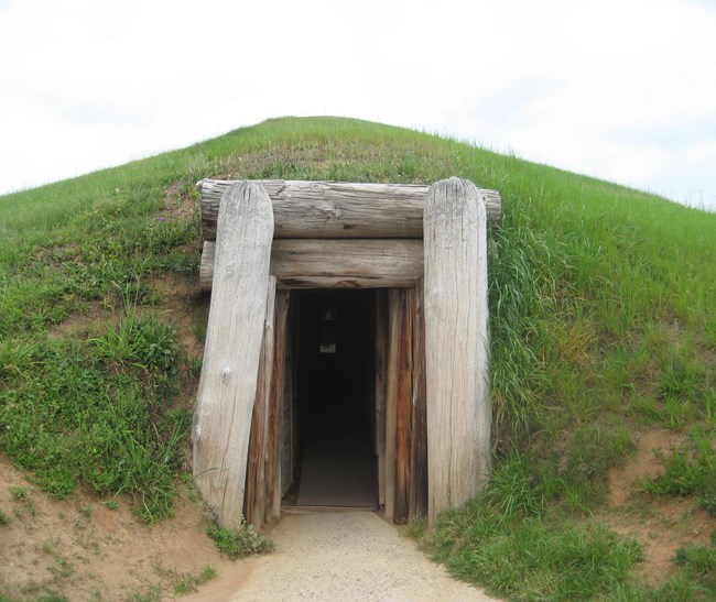
Earthlodge entrance.
Related Links
Ocmulgee National Monument
Narrow By Location
Narrow By Office
Show
10
40
Sort by
Relevance
Recently Updated
Date Released
Title
Loading results...
Tags:
geodiversity
,
geologic
,
[geologic forces](/media/article-search.htm?q=geologic forces)
,
[geologic resources](/media/article-search.htm?q=geologic resources)
,
[geologic feature](/media/article-search.htm?q=geologic feature)
,
[geologic time](/media/article-search.htm?q=geologic time)
,
[geologic layers](/media/article-search.htm?q=geologic layers)
,
[geologic history](/media/article-search.htm?q=geologic history)
,
[geologic formations](/media/article-search.htm?q=geologic formations)
,
geology
,
geological
,
[geological maps](/media/article-search.htm?q=geological maps)
,
geologist
,
[geology talk](/media/article-search.htm?q=geology talk)
,
[geology hike](/media/article-search.htm?q=geology hike)
,
[geology science and learning](/media/article-search.htm?q=geology science and learning)
,
geologists
,
[geology close up](/media/article-search.htm?q=geology close up)
,
[geologic resources inventory](/media/article-search.htm?q=geologic resources inventory)
,
geoheritage
,
geohazards
,
geomorphology
,
[geoscientists in parks](/media/article-search.htm?q=Geoscientists in Parks)
,
geoscientists-in-the-parks
,
[geological survey](/media/article-search.htm?q=Geological Survey)
,
geothermal
,
[geothermal activity](/media/article-search.htm?q=geothermal activity)
,
geotour
,
geotourism
,
[geothermal processes & features](/media/article-search.htm?q=geothermal processes & features)
,
fossils
,
paleontology
,
caves
,
karst
,
glaciers
,
[geoheritage sites](/media/article-search.htm?q=geoheritage sites)
,
earthquakes
,
landslides
,
mining
National Park Service Geodiversity Atlas
The servicewide Geodiversity Atlas provides information on geoheritage and geodiversity resources and values within the National Park System. This information supports science-based geoconservation and interpretation in the NPS, as well as STEM education in schools, museums, and field camps. The NPS Geologic Resources Division and many parks work with National and International geoconservation communities to ensure that NPS abiotic resources are managed using the highest standards and best practices available.
Where this belongs
- Ocmulgee Mounds National Historical Park
Where this page came from
This page was imported from National Park Service. Produced by the U.S. National Park Service and, as a work of the United States government, in the public domain.
Nobody has written it yet — it is the source material at a new address, which is why search engines are asked to skip it and why no one earns from it. It is up for grabs: take it on, and it is yours to rewrite and to earn from.
I disse samlingerOcmulgee Mounds National Historical Park
Licens: CC0 1.0 (offentligt eje) · Bearbejdet efter www.nps.gov
1
0
0
0

Kommentarer
Læs videre


