Etwas zu verbessern? Schlag eine Änderung vor.
On the mostly flat High Plains of Texas, the Canadian River has cut an unexpected canyon country. In it lies Alibates Flint Quarries National Monument: 1,371 acres holding more than 700 flint quarries and other cultural sites, with evidence of 13,000 years of people living in the Canadian River valley. The monument exists to preserve, protect, interpret and study the Alibates flint deposits and the traces left by the Indigenous peoples of the Texas Panhandle who worked them. It shares a border with Lake Meredith National Recreation Area, and the two are managed together. To protect the archeological sites and natural resources, the monument can be visited only on guided tours.
| The prize | Alibates flint, a many-colored chert |
| Where it sits | as lenses and nodules in the Alibates Dolomite, a thin marine layer |
| What surrounds it | Permian red beds, deposited about 260 million years ago |
| What caps the plains | the Ogallala Formation, about 10 million years old |
| What shaped the valley | the Canadian River, helped by salt dissolving underground |
The setting: the Canadian Breaks

Near the park, the Canadian Breaks — outlined by the Caprock Escarpment (red dashed line) — split the High Plains into the Central and Southern High Plains. Graphic by Jason Kenworthy (NPS Geologic Resources Division), after Gustavson and Finley (1985, figure 2); base map by Tom Patterson (NPS).
The Canadian Breaks, also called the Canadian River valley, are a major landform across the Texas Panhandle. They lie below the Caprock Escarpment — the line where the flat plains give way to canyon — and they divide the High Plains into the Central High Plains to the north and the Southern High Plains. The escarpment is an erosional scarp capped by a zone of caliche in the upper Ogallala Formation, up to 30 ft (9 m) thick. The valley also holds Lake Meredith, the reservoir behind Sanford Dam.
Deep below, older structures governed where the Permian and Triassic rocks were laid down. Lake Meredith National Recreation Area sits on the Amarillo uplift, a buried mountain range that rose about 300 million years ago between two basins:
| Structure | Buried under / filled with |
|---|---|
| Amarillo uplift | up to 6,000 ft (1,800 m) of sediment |
| Anadarko Basin — one of the deepest basins in the continental United States | about 40,000 ft (12,000 m) of sedimentary rock |
| Palo Duro Basin | about 10,000 ft (3,000 m) of sediment |
Alibates flint

Alibates flint exposed at the surface in the national monument. NPS photo
What it is. Alibates flint is a form of chert — rock made of submicroscopic crystals of silica — that is mottled or banded in many colors: red, pink, pale blue, pale purple, gray, brown or black. Trace elements make the colors: iron gives reds, oranges and yellows; manganese usually gives blues and deep greens.
Where it is. The flint comes from a 10-square-mile (26 km²) area near Lake Meredith, concentrated in the national monument. It occurs as lenses or nodules in the Alibates Dolomite, a marine layer about 15 ft (4.5 m) thick, and most exposures of that dolomite in the monument contain flint. The flint is much more plentiful in the dolomite's upper layer, though it is not tied to any single bed; the lower layer usually has only small amounts, as spheres and nodules.
How it formed. Silica (silicon dioxide, SiO₂) replaced the original dolomite (calcium magnesium carbonate). Where the silica came from is unknown. It most likely came from the rocks above — candidates include the area's Triassic rocks, which contain chert and petrified wood, the Ogallala Formation, or volcanic ash.
A stone that traveled
The flint takes and holds a hard edge, and people prized it for stone tools for thousands of years. It was in demand along trade routes across North America: points and other tools made of Alibates flint have turned up across the Great Plains and the Southwest, as far north as Montana and as far east as the Mississippi River.
The quarries themselves were shallow pits dug to reach flint that was not fractured or weathered. At their busiest they measured:
| Size | |
|---|---|
| Across | 5 to 25 ft (1.5 to 7 m) |
| Deep | about 4 to 8 ft (1.2 to 2.5 m) |
Over the last 500 years, windblown dust has partly filled them. Today they are shallow hollows at least 6 ft (2 m) across, ringed by heaps of discarded flint.
The rocks around it

Permian red beds exposed beneath the Alibates Dolomite. NPS photo
Permian red beds. Most of the red and white layers in the monument were laid down about 260 million years ago, in the Permian Period, when this part of Texas lay near the equator as part of the supercontinent Pangaea. They are sandstones, siltstones and mudstones with interlayered gypsum and dolomite, deposited at the edge of an arm of the sea that reached up from the south — some on coastal plains, some in marine basins, some on tidal flats. Great quantities of salt and other evaporite minerals went down with them, thousands of feet thick in places, mostly underground and thickest south of Lake Meredith.
- Small amounts of iron oxides and clay minerals give the beds their red-to-orange color.
- The rocks are soft and erode easily, so true outcrops are scarce; they form the rounded hills of much of the Alibates landscape.
- At Alibates they are mapped as one undivided unit spanning three formations — the Whitehorse Sandstone, Cloud Chief Gypsum and Quartermaster Formation. These can usually be told apart only by their order in the rock sequence, and here the marker beds that would show it are missing. The names given to Permian rocks in the Panhandle also have a confusing history.
The Alibates Dolomite is one of the few layers in the red-bed sequence that is easy to recognize: a thin, off-white unit with an upper and a lower dolomite and a red bed between them, though erosion has removed the upper dolomite in many places. The dolomite formed under very salty marine conditions, as on mudflats, while the red beds formed on land. It preserves traces of algal mats in places, resists erosion better than the red beds, and caps most of the mesas and buttes beside Lake Meredith.
Triassic rocks appear in the southwestern part of Lake Meredith National Recreation Area.
The Ogallala Formation lies directly on the Permian red beds. At about 10 million years old it is much younger than the rocks beneath, and the boundary between them is an unconformity — a long gap in the record. It is built of material shed by the eroding mountains to the west — river, lake and wind deposits — and its upper part is caliche, a calcium carbonate hardpan that forms in arid and semi-arid climates.
How the valley was carved
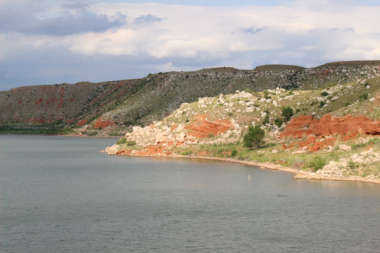
White boulders of Alibates Dolomite tumbling down slopes of Permian red beds are a hallmark of the scenery here. NPS photo
After the Ogallala was laid down, the Canadian River cut down through the caliche caprock within the last few million years, making a valley up to 40 miles (64 km) wide and 1,000 ft (300 m) deep. The Caprock Escarpment is the line of cliffs left as erosion drove them back into the canyons and broken country below.
A modest river carved so large a valley partly because the ground sank beneath it:
- Thick layers of salt and other evaporite minerals formed in an enclosed arm of the sea, before and while the red beds were deposited.
- Groundwater dissolves salt, and the rock above collapses and subsides.
- The Canadian River follows, at least in part, a broad zone of this subsidence across the High Plains. There, the base of the Ogallala has dropped 300–600 ft (100–200 m) relative to the rest of the High Plains.
Much of the dissolution probably happened in the Pleistocene, when the climate was much wetter. It continues today: the Canadian River runs high in salt, and the region has sinkholes.
Karst and collapse chimneys
Most of the monument is evaporite karst, formed where groundwater dissolves the salt (halite) and gypsum in the Permian red beds and the layers above collapse. Its distinctive features are collapse chimneys — round or oval columns filled with collapsed rubble. Most are buried and seen only in road cuts or bluffs, but some stand up above the ground because their rubble fill resists erosion better than the red beds around them. All NPS cave resources are protected by the Federal Cave Resources Protection Act of 1988.
Fossils
No fossils have been found in the Permian red beds, but the area has others:
- Stromatolites — layered algal mats — in the Alibates Dolomite. They form when algal filaments trap carbonate mud, usually on salty tidal flats.
- Vertebrate, invertebrate and plant fossils reported from the Ogallala Formation in or near Lake Meredith National Recreation Area.
All NPS fossil resources are protected by the Paleontological Resources Preservation Act of 2009. More: Paleontological resources of Lake Meredith National Recreation Area and Alibates Flint Quarries National Monument, West Texas.
Hazards and resources today
- Slope movement. Rockfalls, creep, slumps and topples can happen on the monument's slopes, especially where red beds sit beneath caps of harder Alibates Dolomite. The dolomite boulders on the red slopes fell from the canyon rims and may move farther down.
- Flash floods can run in Alibates Creek and the many other streams that feed Lake Meredith.
- Earthquakes. The Panhandle's seismic hazard is relatively low. The USGS 2014 Seismic Hazard Map gives the Alibates area a 2% chance in 50 years of natural shaking exceeding a peak ground acceleration of 10–14% of gravity — roughly intensity VI on the Modified Mercalli scale. The expected number of damaging shaking events in the Panhandle over 10,000 years is 4 to 10. See USGS, Earthquake Hazards: Texas.
- Oil and gas. The Permian and Pennsylvanian rocks of the Panhandle hold oil and gas, and producing wells stand in and around the monument; oil and gas operations in the parks are governed by an oil and gas management plan.

The Alibates Dolomite: the source of the flint, and a "canvas" on which prehistoric people chipped and pecked petroglyphs.
Maps and data
The monument belongs to the Great Plains physiographic province. The NPS Geologic Resources Inventory, which produces digital geologic maps and reports for more than 270 natural resource parks, has the monument's maps and reports; the products available so far are in the NPS DataStore. A Soil Resources Inventory for the monument is also complete (DataStore).

More from the park: geology, petroglyphs, landscape photos, park home. Elsewhere: the Texas Bureau of Economic Geology, the state geological survey.
Sources
Based on "NPS Geodiversity Atlas—Alibates Flint Quarries National Monument, Texas," National Park Service, a product of the Geologic Resources Inventory; a work of the United States government in the public domain. The source's name for the flint-forming process ("certification") and its formula for dolomite (CaMg(CaO3)2) appear to be misprints, so the process is described rather than named and the formula is left out. The source's "evaporate minerals" is corrected to evaporite. Rewritten in hubnx's own words.
Lizenz: CC0 1.0 (gemeinfrei) · Bearbeitet nach www.nps.gov
1
0
0
0

Kommentare