
Etwas zu verbessern? Schlag eine Änderung vor.
Booker T. Washington was born into slavery in 1856 and freed at the age of nine. He rose from slavery and poverty to become an educator, orator and presidential adviser — one of the most influential African Americans of the late nineteenth and early twentieth centuries. Booker T. Washington National Monument preserves the tobacco plantation where he was born.
| Where | Franklin County, Virginia, about 35 km (22 mi) south of Roanoke, just east of the Blue Ridge Parkway |
| Authorized | April 2, 1956 |
| Size | about 97 hectares (239 acres) |
| What's there | replica slave quarters; plantation outbuildings — smokehouse, blacksmith shop, privy, hog pen, duck lot, chicken house; a twentieth-century segregated schoolhouse; three small cemeteries |
Rocks made by colliding continents
The monument lies in the Piedmont physiographic province, close to where it meets the Blue Ridge. This part of Virginia was added to North America by repeated continental collisions and mountain-building events that ended in the Appalachian Mountains. Huge thrust sheets slid over one another along major faults, such as the Fries Fault just west of the monument.
The result is rock laid out in long parallel belts running northeast–southwest, separated by major faults, with a complex history of deformation and metamorphism spanning more than 700 million years — down to today's weathering, erosion and human land use.
| Age of the bedrock | late Proterozoic to Cambrian |
| Oldest exposed rocks | gneiss, schist and amphibolite of the Ashe Formation |
| Younger units | Cambrian amphibolite and laminated mica gneiss |
| Other rock types | biotite gneiss and schist, metaconglomerate, mica schist, quartzite, marble, actinolite schist |
| Structures | small faults, fractures, mylonite zones, foliation and minor folds; joints and fractures are everywhere, mostly following the northeast–southwest trend. Parallel thrust faults cross the area and may still be taking up stress in the crust |
Most of these ancient rocks are deeply weathered and buried under a thick blanket of regolith — loose weathered material.

The landscape
The monument is gently rolling country of hills and valleys. Big terrace and alluvial fan deposits cap the higher ground between streams, and the active stream valleys are filled with loose alluvium.
- Elevation runs from under 260 m (840 ft), where Gills Creek meets Jack-O-Lantern Branch, to just over 300 m (1,000 ft) near the entrance road.
- Gills Creek and Jack-O-Lantern Branch are the monument's only year-round streams, part of the Roanoke River watershed. Two unnamed streams and many seeps and springs — some feeding Jack-O-Lantern Branch — rise here too.
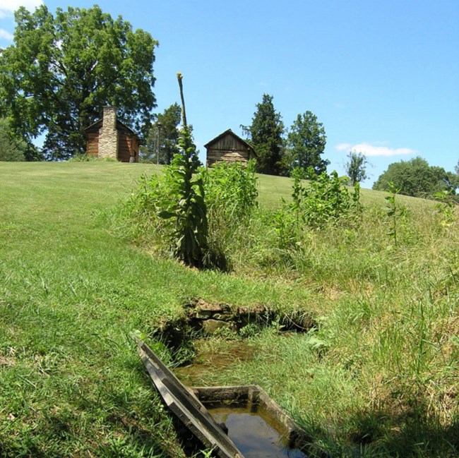
A spring box, an early refrigerator: holes at each end let cool, fresh water flow through, keeping food fresh for several days. NPS photo by Timbo Sims
Stones and settlers
Bedrock outcrops are rare — where they show, it is as ledges in streams — but rocks loosened by weathering and downslope movement litter the ground. Early settlers piled the bigger ones into irregular mounds and straight lines that still run through the monument's woods. Nobody knows what the lines were for; perhaps to mark fields or property boundaries, or to serve as fences. Local stone probably went into foundations and chimneys, reused and recycled over the site's long history, and an old stone foundation of a barn or tobacco building survives. Old stone walls in a dam near the boundary suggest rock was quarried, but no quarry has been found.
What geology shapes here
Geology underlies the monument's ecosystem, has influenced its history, and still affects:
- surface water quality and the water supply
- sediment load, stream channel shape and erosion
- seeps and springs
- shrink-and-swell clays
- earthquakes
- development next to the monument
Maps and data
The NPS Geologic Resources Inventory, which produces digital geologic maps and reports for more than 270 natural resource parks, has products for the monument in the NPS DataStore, and a Soil Resources Inventory for it is complete (DataStore). The monument belongs to the Piedmont province and is influenced by the neighboring Blue Ridge province.
Sources
Based on "NPS Geodiversity Atlas—Booker T Washington National Monument, Virginia," National Park Service, a product of the Geologic Resources Inventory drawing on its 2010 report and the 2009 scoping notes; a work of the United States government in the public domain. The image of the GRI report's cover is left out; rewritten in hubnx's own words.
In diesen PublikationenBooker T Washington National Monument
Lizenz: CC0 1.0 (gemeinfrei) · Bearbeitet nach www.nps.gov
1
0
0
0

Kommentare


