
The companion web site for NAWQA summary reports:
http://water.usgs.gov/nawqa/nawqa_sumr.html
River Basin Assessments
Front cover: Spokane River near Spokane, Washington (Photograph by Lan Tornes). Back cover: Left, Mining-affected tributary to the South Fork Coeur d’Alene River (Photograph by Lan Tornes); Center, Lake Pend Oreille (Photograph by Lan Tornes); Right, Collecting fish samples (Photograph by Terry Maret). National NAWQA Program:
National Assessments
By Gregory M. Clark, Rodney R. Caldwell, Terry R. Maret, Craig L. Bowers, DeAnn M. Dutton, and Michael A. Beckwith Gale A. Norton, Secretary
iii
National Water-Quality Assessment Program ………………………………………………… iv What kind of water-quality information does the NAWQA Program provide? …………… v Introduction to this Report …………………………………………………………………… vi Summary of Major Findings …………………………………………………………………… 1 Stream and River Highlights …………………………………………………………… 1 Ground-Water Highlights ………………………………………………………………… 2 Introduction to the Northern Rockies Intermontane Basins ………………………………… 3 Major Findings ………………………………………………………………………………… 6 Historical mining activities have degraded water-quality conditions in numerous streams ………………………………………………………… 6 Nutrient concentrations in streams generally are low ………………………………… 11 Fish in the Spokane River contain polychlorinated biphenyls (PCBs) at elevated concentrations ……………………………………………………………… 13 The Spokane River also contains low concentrations of pesticides and volatile organic compounds ………………………………………………………… 14 Ground water in aquifers used for drinking-water supply in Spokane, Coeur d’Alene, and Missoula is generally of good quality ……………………………… 15 Study Unit Design …………………………………………………………………………… 18 Stream Chemistry and Ecology ………………………………………………………… 18 Ground-Water Chemistry ……………………………………………………………… 18 References Cited ……………………………………………………………………………… 20 Glossary ……………………………………………………………………………………… 23 Appendix ……………………………………………………………………………………… 25 iv
The quality of the Nation’s water resources is integrally linked to the long-term availability of water that is clean and safe for drinking and recreation and also suitable for industry, irrigation, and habitat for fish and wildlife. Recognizing the need for long-term, nationwide assessments of water resources, the U.S. Congress has appropriated funds since 1991 for the USGS to conduct the National Water-Quality Assessment (NAWQA) Program. Scientists in the NAWQA Program work with partners in government, research, and public interest groups to assess the spatial extent of water-quality conditions, how water quality changes with time, and how human activities and natural factors affect water quality. This information is useful for guiding watermanagement and protection strategies, research, and monitoring in different hydrologic and land-use settings across the Nation.

The Northern Rockies Intermontane Basins is one of 51 water-quality assessments initiated since 1991. Together, the 51 major river basins and aquifer systems, referred to as “Study Units,” include water resources used by more than 60 percent of the population in watersheds that cover about half of the land area of the conterminous United States. Timing of the assessments varies because of the Program’s rotational design, in which one-third of all Study Units are intensively investigated for 3 to 4 years, with trends assessed every 10 years. As indicated on the map, the Northern Rockies Intermontane Basins is part of the third set of intensive investigations, which began in 1997.
What kind of water-quality information does the NAWQA Program provide?
Water-quality assessments by a single program cannot possibly address all of the Nation’s water-resources needs and issues. Therefore, it is necessary to define the context within which NAWQA information is most useful.
- Total resource assessment—NAWQA assessments are long-term and interdisciplinary, and include information on water chemistry, hydrology, land use, stream habitat, and aquatic life. Assessments are not limited to a specific geographic area or water-resource problem at a specific time. Therefore, the findings describe the general health of the total water resource, as well as emerging water issues, thereby helping managers and decision makers to set priorities.
- Source-water characterization—Assessments focus on the quality of the available, untreated resource and thereby complement (rather than duplicate) Federal, State, and local programs that monitor drinking water. Findings are compared to drinking-water standards and health advisories as a way to characterize the resource.
- Compounds studied—Assessments focus on chemical compounds that have well-established methods of investigation. It is not financially or technically feasible to assess all the contaminants in our Nation’s waters. In general, the NAWQA Program investigates those pesticides, nutrients, volatile organic compounds, and metals that have been or are currently used commonly in agricultural and urban areas across the Nation. A complete list of compounds studied is on the NAWQA Web site at http://water.usgs.gov/nawqa.
- Detection compared to risk—Compounds are measured at very low concentrations, often 10 to 100 times lower than Federal or State standards and health advisories. Detection of compounds, therefore, does not necessarily translate to risks to human health or aquatic life. However, these analyses are useful for identifying and evaluating emerging issues, as well as for tracking contaminant levels over time.
- Multiple scales—Assessments are guided by a nationally consistent study design and uniform methods of sampling and analysis. Findings thereby pertain not only to water quality of a particular stream or aquifer but also contribute to the larger picture of how and why water quality varies regionally and nationally. This consistent, multiscale approach helps to determine if a water-quality issue is isolated or pervasive. It also allows direct comparisons of how human activities and natural processes affect water quality in the Nation’s diverse environmental settings.
vi
“ Understanding river and aquifer interaction often is critically linked to the consumptive needs of our citizenry, stream aquatic life, and riparian health, and ultimately our quality of life. Focused USGS scientific studies are assisting state and local government to protect water quality, manage water resources, and preserve natural systems such as the Spokane River and Spokane Valley-Rathdrum Prairie Aquifer in Washington and Idaho.” This report contains the major findings of a 1999–2001 assessment of water quality in the Northern Rockies Intermontane Basins. It is one of a series of reports by the National Water-Quality Assessment (NAWQA) Program that present major findings in 51 major river basins and aquifer systems across the Nation.
In these reports, water quality is discussed in terms of local, State, and regional issues. Conditions in a particular basin or aquifer system are compared to conditions found elsewhere and to selected national benchmarks, such as those for drinking-water quality and the protection of aquatic organisms.
This report is intended for individuals working with water-resource issues in Federal, State, or local agencies, universities, public interest groups, or in the private sector. The information will be useful in addressing a number of current issues, such as the effects of agricultural and urban land use on water quality, human health, drinking water, source-water protection, hypoxia and excessive growth of algae and plants, pesticide registration, and monitoring and sampling strategies. This report is also for individuals who wish to know more about the quality of streams and ground water in areas near where they live, and how that water quality compares to the quality of water in other areas across the Nation.
The water-quality conditions in the Northern Rockies Intermontane Basins summarized in this report are discussed in detail in other reports that can be accessed from (http://id.water.usgs.gov/nrok/index.html). Detailed technical information, data and analyses, collection and analytical methodology, models, graphs, and maps that support the findings presented in this report in addition to reports in this series from other basins can be accessed from the national NAWQA Web site (http://water.usgs.gov/nawqa).
Stream and River Highlights Major Influences on Water Quality in Streams and Rivers
Hard-rock mining, agriculture, urbanization, logging, and other activities have altered water quality and aquatic biological communities in streams and rivers of the Northern Rockies Intermontane Basins. Concentrations of trace elements in streambed sediment exceed guidelines established for the protection of aquatic life in many streams in the Clark Fork-Pend Oreille and Spokane River Basins. Fish and invertebrate communities also show adverse effects from elevated concentrations of trace elements. Concentrations of the nutrients nitrogen and phosphorus in streams are generally low; however, some concentrations approach or exceed recommended goals for preventing nuisance plant growth in streams. Excessive nutrients and potential eutrophication are a concern for Flathead Lake, Lake Pend Oreille, and Coeur d’Alene Lake, where residential and commercial development and recreational uses are increasing rapidly.
- Concentrations of arsenic, cadmium, copper, lead, mercury, and zinc in streambed sediment exceeded guidelines for the protection of aquatic life (by as much as 40 times for some elements at some sites). Concentrations of copper in sediment from the upper Clark Fork, and concentrations of arsenic, cadmium, mercury, lead, and zinc in sediment from the South Fork Coeur d’Alene and Coeur d’Alene Rivers were among the highest in more than 1,200 streams sampled by the NAWQA Program across the Nation. Concentrations of trace elements in livers of fish and in tissue of invertebrates in mining-affected streams were elevated above natural background levels, and the abundance and diversity of fish and invertebrate species were greatly reduced. Trace-element concentrations in sportfish fillets, however, were generally low, with none in excess of U.S. Environmental Protection Agency (USEPA) human-health screening values for fish consumption (p. 7−10).

- The load, or mass, of trace elements transported in streams is highly variable, depending on annual precipitation and streamflow. During 1999 and 2000, an average of about 8,900 lb/yr (pounds per year) of cadmium, 500,000 lb/yr of lead, and 1.4 million lb/yr of zinc entered Coeur d’Alene Lake from the Coeur d’Alene River. The lake retained about 48 percent of the cadmium, 91 percent of the lead, and 30 percent of the zinc; the remaining trace elements were transported through the lake and into the Spokane River (p. 8).
- Nutrient concentrations in streams generally were low, often below minimum reporting levels. Only 2 of 10 streams sampled routinely (the South Fork Coeur d’Alene River near Pinehurst, Idaho, and the Spokane
Annual variability in precipitation and streamflow
Runoff from historical mining
Urban runoff and sewage-treatment effluent
River at Seven Mile Bridge near Spokane, Washington)
contained a median concentration of total nitrogen higher than a national background concentration of 0.26 mg/L (milligrams per liter) for relatively undisturbed sites. The Clark Fork at Turah Bridge, Montana, South Fork Coeur d’Alene River near Pinehurst, Idaho, and Spokane River at Seven Mile Bridge near Spokane, Washington, contained a median concentration of total phosphorus higher than a national background concentration of 0.02 mg/L for relatively undisturbed sites. Elevated concentrations of total nitrogen and phosphorus in the South Fork Coeur d’Alene River near Pinehurst and in the Spokane River at Seven Mile Bridge near Spokane are attributable to sewage-treatment effluent. Elevated concentrations of chlorophyll-a, which are indicative of algal growth on streambeds and moderate nutrient enrichment, were measured in the Spokane, Flathead, and Bitterroot Rivers (p. 11−12).
- Concentrations of polychlorinated biphenyls (PCBs) in fillet and whole-body samples of fish from the Spokane River near Spokane exceeded recommended limits for
human consumption and for the protection of fish-eat-
Major Influences on Ground-Water Quality
ing wildlife. PCB concentrations in samples of whole-body fish from the Spokane River ranked among the upper 25 percent of concentrations in fish from more than 700 streams sampled by the NAWQA Program nationwide. No other organochlorine compounds in fish tissue exceeded human health or wildlife protection guidelines (p. 13).
Ground-Water Highlights
Ground water accounts for about 19 percent of the total water used in the Northern Rockies Intermontane Basins and is the primary source of water for municipal, domestic, and industrial supplies. The Spokane Valley/Rathdrum Prairie and Missoula/Bitterroot basin-fill aquifers underlying Spokane, Coeur d’Alene, and Missoula currently supply drinking water for about 70 percent of the population in the basins and have been designated as sole-source aquifers by the USEPA. In general, the quality of water in these sole-source aquifers reflects minimal evidence of human activities despite continued urban development. These sole-source aquifers are particularly vulnerable to contamination, however, because of a relatively shallow water table, porous aquifer materials, and relatively rapid rates of recharge, and in some places they already contain low concentrations of trace elements and organic chemicals.

- Arsenic concentrations exceeded the USEPA drinking-water standard of 10 μg/L (micrograms per liter) in only 3 of 31 wells sampled in the basin-fill aquifers underlying the Spokane/Coeur d’Alene area and in none of 30 wells sampled in the basin-fill aquifers underlying the Missoula/Bitterroot area. None of the 61 wells sampled contained nitrate concentrations exceeding the USEPA drinking-water standard of 10 mg/L (p. 15−16). Soil and aquifer properties
Urban land use and development
- Radon concentrations in ground-water samples ranged from 253 to 3,050 pCi/L (picocuries per liter) with the highest concentrations found along the relatively thin margins of the aquifers in the Spokane/Coeur d’Alene area and along the western edge of the Bitterroot Valley. Only one sample contained a radon concentration less than the USEPA proposed drinking-water standard of 300 pCi/L, and none of the samples contained concentrations exceeding 4,000 pCi/L, a less stringent standard being proposed by some States in cooperation with the USEPA (p. 16).
- Volatile organic compounds (VOCs) were detected in 19 of 61 samples collected from the basin-fill aquifers, and pesticides were detected in 15 samples; 5 samples (8 percent) contained mixtures of VOCs and pesticides. Nearly all detected compounds, however, were at low concentrations; none exceeded or even approached established drinking-water standards and guidelines (p. 17).
- The Spokane River exchanges water with the underlying aquifer between Coeur d’Alene Lake and Spokane. In the upstream part of the reach, water from the river seeps to the aquifer; the exchange reverses farther downstream near Spokane, where ground water discharges back to the river. Concentrations of dissolved zinc in some near-river alluvial wells were slightly elevated (about 75 μg/L) as a result of recharge from the Spokane River; however, the concentrations in the aquifer rapidly decreased with distance from the river. Concentrations of other trace elements in near-river wells were near or below minimum reporting levels, and all were below drinking-water standards and guidelines (p. 10−11). The Northern Rockies Intermon-
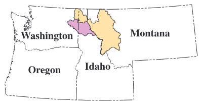
tane Basins encompass 31,500 square miles (mi) in western Montana, northern Idaho, and northeastern Washington (fig. 1). The study unit includes two major river basins: the Clark Fork−Pend Oreille River Basin (about 79 percent of the unit) and the Spokane River Basin (about 21 percent). Most of the study area lies within the Northern Rocky Mountains physiographic province. Topography ranges from high, mountainous areas where elevations exceed 10,000 feet (ft) to large, flat valleys at elevations as low as 1,000 ft (Maret and Dutton, 1999). The unit contains numerous large natural lakes, including Flathead Lake (the largest natural freshwater lake in the Western United States), Lake Pend Oreille (one of the deepest lakes in the United States), and Priest and Coeur d’Alene Lakes, which are used extensively for fishing, boating, and other recreational activities.
Hydrologic conditions affect water quality in streams and ground water
Water quality in streams, rivers, and shallow ground water often varies in response to hydrologic conditions; thus, information on streamflow and other hydrologic conditions is critical for assessing water quality. For example, when precipitation and runoff are below average, streamflow is lower than normal, and concentrations of suspended sediment and constituents that attach to
sediment particles, such as phosphorus and some trace elements, often are lower than average. In contrast, concentrations of dissolved constituents, particularly those contributed by ground water and sewage-treatment effluent, commonly are higher than average when precipitation and streamflow are low. During 1999 and 2000, streamflow at most sites was about average. Water year 2001 was drier than normal, and streamflow at all sites was typically about 40 to 60 percent of the 30-year historical average (fig. 2).
Average annual precipitation in the Study Unit ranges from less than 15 inches in many of the mountain valleys of western Montana to more than 100 inches (primarily in the form of snow) in mountainous regions of northwestern Montana. The magnitude and quality of streamflow generally are determined by the amount of water derived from the winter snowpack. Streamflow typically is highest during the spring and lowest during the fall and winter; average annual runoff (the volume of water leaving a basin per unit of basin area) ranges from less than 5 inches at lower elevations to more than 50 inches at higher elevations (Tornes, 1997).

Figure 2. Streamflows were generally average during 1999−2000. Streamflows during 2001 were only about 40−60 percent of the 30-year historical average.
Land-use activities, such as mining, affect water quality in the basins
The Northern Rockies Intermontane Basins primarily are forested (about 75 percent); the remaining land is agricultural (8 percent), rangeland (11 percent), urban (1 percent), and other uses (5 percent). Agricultural activities occur primarily in the upper Clark Fork, the Bitterroot and Flathead River Basins in Montana, and in tributary basins of the Spokane River. Although urban land accounts for only 1 percent of the study unit, cities such as Missoula, Coeur d’Alene, and Spokane are growing rapidly. From 1990 to 2000, the total population in the counties containing these three cities grew by an average of 22 percent (U.S. Census Bureau, 2000).
Water quality in streams, rivers, lakes, and shallow ground water is affected by land-use activities, including mining, urban development, agriculture, and municipal and industrial discharge of wastewater. Mining activities have had a major effect on water quality; about 1,600 active and abandoned hard-rock mines of various sizes have been documented (Maret and Dutton, 1999). In the upper Clark Fork Basin, mine tailings have been transported and deposited along more than 150 miles (mi) of river channel and flood plain from Butte to near Missoula (Andrews, 1987). Similarly, tailings discharged directly to the South Fork Coeur d’Alene River have been transported and deposited along 60 mi of the river channel and flood plain of the Coeur d’Alene River, on the bottom of Coeur d’Alene Lake, and out of the lake into the Spokane River (Grosbois and others, 2001). These tailings typically contain elevated concentrations of arsenic, cadmium, copper, lead, and zinc. Toxic effects of these trace elements have led to numerous fishkills in the upper Clark Fork since 1984 (Phillips and Lipton, 1995) and a depleted population of benthic invertebrates in Coeur d’Alene Lake (Woods and Beckwith, 1997).
High-elevation, headwater streams in forested watersheds have generally excellent water quality and healthy biological communities, except in some areas affected by logging, mining, and recreation. Historical logging practices common to some forested areas in the Northern Rockies Intermontane Basins often introduced large amounts of sediment to streams, primarily from massive soil erosion and severely destabilized streambanks and channels (Woods and Beckwith, 1997). Forest fires also can influence water quality; runoff from burned areas transports eroded sediment and ash to streams.
In lower elevation areas, water quality is affected by land-use activities involving livestock grazing, dryland and irrigated agriculture, and urban development. Runoff from agricultural land commonly contributes sediment, nutrients, and pesticides to streams. Runoff from urban areas commonly contributes nutrients, bacteria, pesticides, organic chemicals, and trace elements to streams and aquifers. Nutrients (primarily nitrogen and phosphorus) are of special concern for Coeur d’Alene Lake, Flathead Lake, and Lake Pend Oreille because of the potential for eutrophication and excessive algal growth in these low-productivity lakes. Other sources of nutrients to streams include municipal wastes, septic-system effluent, and soil erosion from logging.
Surface water is used primarily for irrigation and ground water is used primarily for drinking-water and industrial supplies
Total water use reported during 2000 in the Study Unit averaged about 1,350 million gallons per day (fig. 3). Irrigation, primarily from surface-water sources in the Clark Fork–Pend Oreille River Basin, accounted for about 81 percent of the total water use. Although surface-water sources provide most of the water for agricultural use, ground water is the main source for public, domestic, and industrial supplies. Although ground water accounts for only about 19 percent of the total water used in the basins, it accounts for about 70 percent of the drinking-water supply. As the population in the Study Unit continues to grow, the amount of ground water used for public supply also will continue to grow.
On the Clark Fork and the Flathead and Spokane Rivers, 16 dams regulate streamflow for hydroelectric-power generation and flood control (Maret and Dutton, 1999). The dams, however, also alter the natural hydrologic patterns of rivers and act as barriers to fish passage.

Figure 3. Agriculture accounts for 81 percent of the water used in the Study Unit, primarily in the Clark Fork−Pend Oreille River Basin. Although ground water accounts for only 19 percent of the water used in the study unit, it accounts for 70 percent of the drinkingwater supply.
Ground water is vulnerable to contamination
Principal aquifers used for water supply in the basins are in basin-fill deposits along most reaches of large rivers and major tributaries. These basin-fill aquifers are composed primarily of gravel, sand, silt, and clay derived from glacial outburst floods, glacial debris, alluvial fans, stream transport, and lakebed sediment. The heterogeneous nature of these unconsolidated materials results in a large range of hydraulic properties, which in turn results in variable productivity of wells.
Introduction
The Spokane Valley/Rathdrum Prairie and Missoula/Bitterroot basin-fill aquifers underlying Spokane, Coeur d’Alene, and Missoula currently supply drinking water to about 70 percent of the population in the Study Unit and have been designated as sole-source aquifers by the USEPA. These aquifers provide the only economically available supply of drinking water for these cities. The aquifers are particularly vulnerable to contamination, however, because of a relatively shallow water table, porous aquifer materials, and relatively rapid rates of recharge.
Historical mining activities have degraded water-quality conditions in numerous streams
Mining has been central to the economy of many communities in Montana and Idaho since the late 1800s. In the past, mining activities yielded large volumes of metal-rich tailings that were commonly deposited in nearby streams or along their banks and flood plains. In a comprehensive investigation of mining in the Coeur d’Alene River Basin by the U.S. Bureau of Fisheries in 1932, Dr. M.M. Ellis found “that as far as fisheries are concerned, the mine wastes poured in the South Fork of the Coeur d’Alene River have reduced 50 miles of the South Fork and Main Coeur d’Alene River to a barren stream practically without fish fauna, fish food, or plankton, and with enormous lateral supplies of potentially toxic materials which will continue to poison the


Figure 4. Concentrations of some trace elements in streambed sediment at some sites exceeded guidelines for the protection of aquatic life by as much as 40 times. The highest concentrations of trace elements were from streams within, or downstream from, USEPA Superfund sites affected by historical mining.
Trace elements in streambed sediment - How toxic?
Trace-element concentrations in streambed sediment, such as those shown in figure 4, are compared with a probable effect level, or PEL, established as a Canadian Sediment Quality Guideline (Canadian Council of Ministers of the Environment, 1999) for the protection of aquatic life. According to the guideline, trace-element concentrations in bulk sediment exceeding the PEL frequently are associated with adverse biological effects. NAWQA samples represent the fine-grained fraction of bed sediment only (less than 63 micrometers), which, in general, contains higher concentrations of trace elements than bulk sediment does. NAWQA samples, therefore, may somewhat overstate the problem based on bulk-sediment criteria, and caution should be used in applying the criteria to values close to the PEL.
waters of the Coeur d’Alene River for a considerable period of time” (Ellis, 1940). Although most mining activities in the basins have been discontinued or curtailed, and practices to minimize the adverse effects have been improved, erosion and runoff continue to transport and disperse tailings downstream, which
Concentrations of arsenic, cadmium, copper, lead, mercury, and zinc in more than 50 percent of the streambed-sediment samples collected in the Clark Fork-Pend Oreille and Spokane River Basins exceeded national median concentrations for these trace elements in more than 1,200 samples collected by the NAWQA Program from all land-use settings in 48 major river basins. Concentrations of each of these trace elements in more than 30 percent of the samples ranked among the highest 10 percent of national concentrations. Concentrations of copper in streambed sediment from the Clark Fork near Galen and at Turah and concentrations of arsenic, cadmium, mercury, lead, and zinc in streambed sediment from the South Fork and Coeur d’Alene Rivers were among the highest 1 percent of national concentrations.
Concentrations of some trace elements associated with mining were among the highest in streambed sediment sampled across the Nation
are subsequently redeposited in stream sediment, lake bottoms, and flood plains. It has been estimated that mining has introduced more than 100 million tons of metal-enriched tailings to both the Clark Fork (Andrews, 1987) and the South Fork Coeur d’Alene River Basins (Long, 1998).
Mining contributes to elevated concentrations of trace elements in streambed sediment
Potentially harmful concentrations of trace elements have accumulated in streambed sediment in numerous streams in the Clark Fork−Pend Oreille and Spokane River Basins. Concentrations of six trace elements (arsenic, cadmium, copper, lead, mercury, and zinc) exceeded sediment-quality guidelines for protection of aquatic life (PEL) in the Clark Fork near Galen and Turah, Montana (sites 1 and 2); the South Fork Coeur d’Alene River near Pinehurst, Idaho (site 18); the Coeur d’Alene River near Harrison, Idaho (site 19); and the Spokane River near Post Falls, Idaho (site 20) (fig. 4). These sites are downstream from areas that have been heavily affected by historical mining and designated as USEPA Superfund
sites. Although these streams are not used as a source for drinking water, the frequent and elevated occurrence of trace elements in sediment is a potential concern for wildlife, recreational use, and fish consumption. Concentrations of trace elements were lowest in streambed sediment from near-pristine areas of the Middle Fork Flathead River in Montana, and the St. Joe River at Red Ives in Idaho.
Trace elements are transported downstream in the Clark Fork and Coeur d’Alene River Basins and accumulate in lakes
Transport of trace-element contaminants in the Clark Fork and Coeur d’Alene River Basins can be substantial. For example, about 34,000 pounds (lb) of copper, 6,000 lb of lead, and 56,000 lb of zinc were transported annually in the Clark Fork at Turah during water years 1999−2001 (site 2 in fig. 4). These loads actually may underestimate average rates of transport because precipitation, runoff, and streamflow were near or below normal during those years (streamflows ranged from 63 to 113 percent of normal compared with the 15- year period 1986−2001). Precipitation and runoff, which wash contaminated sediment from source areas into streams, control the transport and subsequent downstream distribution. For example, during water year 1997, when the annual mean streamflow in the Clark Fork was about 180 percent of the historical average, about 5 to 7 times more copper (220,000 lb), lead (38,000 lb), and zinc (320,000 lb) were transported in the Clark Fork at Turah than during water years 1999−2001 (Lambing, 1998).
Excessive amounts of trace elements also can enter streams during storms and periods of high snowmelt runoff. For example, high flows in the Coeur d’Alene River following a heavy rain on snowpack in February 1996 transported about 1.4 million lb of lead into Coeur d’Alene Lake in 1 day (Beckwith, 1996), which is about 4 times the average annual load of lead (360,000 lb) transported into the lake during 1999−2001 (Clark, 2003).

Figure 5. During 1999−2000, Coeur d’Alene Lake retained about 46 percent of the combined load of cadmium, lead, and zinc entering the lake. The remainder was transported out of the lake and into the Spokane River. The lake is especially efficient at retaining lead, which adheres to sediment particles and is subsequently deposited on the lake bottom.
Large quantities of trace elements are transported to and deposited on the bottom of Coeur d’Alene Lake (Horowitz and others, 1993; Bookstrom and others, 2001; Woods, 2001). About 82.5 million tons of trace-element-enriched sediment, covering about 85 percent of the lakebed, have been deposited in Coeur d’Alene Lake since the late 1800s (Horowitz and others, 1995). Median concentrations of arsenic, cadmium, lead, mercury, and zinc in surficial lakebed sediment samples collected during the early 1990s from enriched areas of the lake exceeded sediment-quality guidelines for the protection of aquatic life by as much as 10 times (Woods and Beckwith, 1997).
Trace elements continue to accumulate in Coeur d’Alene Lake. About 8,900 lb of total cadmium, 500,000 lb of total lead, and 1.4 million lb of total zinc entered Coeur d’Alene Lake each year during 1999−2000 from the Coeur d’Alene River (Clark, 2003). Not all of these trace elements, however, are retained in the lake. For example, about 4,600 lb of cadmium and 980,000 lb of zinc, or about 52 and 70 percent of the annual loads entering the lake were transported from the lake, primarily in a dissolved form, and into the Spokane River during 1999−2000 (fig. 5). Because lead is less soluble than cadmium and zinc in water, the lake is more efficient in retaining lead, which adheres to sediment particles that settle to the lakebed. During 1999−2000, only about 44,000 lb/yr, or about 9 percent of the lead entering the lake, was transported from the lake into the Spokane River. Elevated concentrations of trace elements in streambed sediment in the Spokane River near Post Falls and farther downstream (Beckwith, 2002) most likely result from transport through Coeur d’Alene Lake. Likewise, elevated concentrations of trace elements (above natural background levels) in streambed sediment from the Pend Oreille River downstream from Lake Pend Oreille (Beckwith, 2002) indicate trace-element transport throughout the length of the Clark Fork and through the lake.
Trace-element contamination may be adversely affecting aquatic life
Streambeds provide habitat for many aquatic organisms. Streambed sediment contaminated with trace elements can be toxic to aquatic invertebrates (worms, clams, and insect larvae) or can provide a sublethal source of exposure causing bioaccumulation in invertebrate tissues and a concentrated source of trace elements in the diet of fish (Woodward and others, 1995). Previous studies in the upper Clark Fork have documented adverse effects of trace elements, including bioaccumulation in insect communities (Axtmann and others, 1997), fishkills (Phillips and Lipton, 1995), and reduced fish diversity and populations (Marr and others, 1995).
Trace-element concentrations in the tissue of aquatic biota are elevated
Tissue samples from caddisfly larvae and fish indicate that elevated concentrations of trace elements in water and streambed sediment contribute to elevated concentrations in biota. Data from the Coeur d’Alene River Basin showed that concentrations of cadmium, lead, and zinc in tissues of caddisfly larvae were statistically correlated with concentrations of trace elements in the sediment and water, all of which were related to upstream mining activity (Maret and others, 2003). Concentrations of trace elements in caddisflies were highest at sites in the basin affected by historical mining. For example, concentrations of lead in caddisflies from the South Fork Coeur d’Alene River at Silverton were almost 100 times higher than the median lead concentration in caddisflies from three unaffected reference sites on the St. Regis River in Montana.
Historical mining activities also have affected concentrations of trace elements in fish, as measured in fish livers. For example, the highest concentrations of cadmium, lead, and zinc were in liver samples of fish from the mining-affected South Fork Coeur d’Alene River near Pinehurst (fig. 6) (Maret and Skinner, 2000). Consistent with trace elements in streambed sediment, concentrations of trace elements were lowest in liver samples of fish from relatively pristine areas of the Middle Fork Flathead River, Montana, and the St. Joe River at Red Ives, Idaho. Concentrations of some trace elements, however, were elevated in streams relatively unaffected by mining. Specifically, concentrations of copper and mercury were highest in livers of fish from Rock Creek, a tributary of the Clark Fork near Clinton, Montana (site 4), and the Bitterroot River near Missoula, Montana (site 5). Copper and mercury in streambed sediment at these two relatively unaffected sites were low; therefore, elevated concentrations in the fish-liver samples probably reflect fish migration into tributaries from the Clark Fork, where the trace elements originally were bioaccumulated.

Figure 6. Concentrations of trace elements in liver samples of fish collected from the Northern Rockies Intermontane Basins generally ranked in the top 50 percentile of concentrations in fish collected from 462 streams nationwide by the NAWQA Program. Concentrations of cadmium, copper, and lead in fish from some sites exceeded the NAWQA national median by more than 10 times.
Major Findings
In contrast to trace-element concentrations in liver samples, concentrations in sportfish (trout and whitefish) fillets were relatively low. No fillet samples from fish collected in the Study Unit contained concentrations in excess of USEPA human-health screening values for fish consumption (Maret and Skinner, 2000). This finding is noteworthy because mercury, in particular, is known to bioaccumulate in muscle tissue of fish and subsequently is passed through the food chain to predatory wildlife and humans (Wiener and Spry, 1996).
Species diversity is reduced in mining-affected streams
Elevated concentrations of trace elements also have contributed to reduced diversity and abundance of native fish and invertebrate species and increased abundance of nonnative fish species. For example, sculpins, which are sensitive to pollution, were scarce or nonexistent at mining-affected sites (Maret and MacCoy, 2002). Although trout also were less abundant at mining-affected sites, they still were collected at sites, such as the South Fork Coeur d’Alene River near Pinehurst, where concentrations of dissolved trace elements in water exceeded USEPA chronic water-quality criteria for the protection of aquatic life (Hornig and others, 1988). Invertebrate species sensitive to pollution, such as stoneflies, mayflies, and caddisflies, were not as common at mining-affected sites as at sites unaffected by mining (Maret and others, 2003). Specifically, the median density of invertebrates at the mining-affected sites (about 400 individuals per square foot) was significantly lower than at reference sites (about 770 individuals per square foot). Fewer than 150 invertebrate individuals per square foot were present at the mining-affected sites at the mouth of Canyon Creek in the South Fork Coeur d’Alene River Basin and at the South Fork Coeur d’Alene River at Silverton.
Trace-element contamination in the Spokane River is a concern
Elevated concentrations of trace elements in the Spokane River are of priority concern to water-quality managers (Grosbois and others, 2001). In 2000, the State of Idaho and the USEPA developed and issued a total maximum daily load (TMDL) to allocate trace-element loading in the Spokane River Basin in Idaho. The Washington State Department of Ecology also has placed the Spokane River on its EPA 303(d) list for trace-element concentrations in violation of Washington’s water-quality criteria (Washington State Department of Ecology, 2000b).


Trace-element concentrations in water were highest within impoundments or low-velocity sections of the river near the outlet of Coeur d’Alene Lake, where fine-grained sediment is trapped (Grosbois and others, 2001). Concentrations generally decreased with increased distance downstream from Coeur d’Alene Lake as a result of sedimentation and mixing with more dilute inflows. Concentrations of arsenic, cadmium, lead, mercury, and zinc in streambed sediment from the Spokane River near Post Falls exceeded sediment-quality guidelines for the protection of aquatic life and were between 3 and 14 times higher than the concentrations downstream near Spokane.
Trace-element concentrations in water and sediment in the Spokane River have raised human health concerns about potential contamination of the underlying Spokane Valley/Rathdrum Prairie aquifer, which supplies drinking water to the cities of Coeur d’Alene and Spokane and the surrounding area. During high stream discharge, the Spokane River may lose more than 500 cubic feet per second (ft/s) of its flow to the aquifer between Coeur d’Alene Lake and Spokane (Bolke and Vaccaro, 1981; Gearhart and Buchanan, 2000). Seepage from the Spokane River to the aquifer transports dissolved trace elements, primarily zinc, into the aquifer. Movement of trace elements in ground water within
Nutrient concentrations in many streams were among the lowest in the Nation
Nutrient concentrations in the Northern Rockies Intermontane Basins were among the lowest when compared with 479 streams sampled by the NAWQA Program that drain undeveloped, urban, agricultural, and mixed land-use basins across the Nation. Concentrations of total nitrogen at 9 of 10 sites in this Study Unit were among the lowest 10 percent nationally; concentrations in the Spokane River at Seven Mile Bridge near Spokane were among the lowest 30 percent. Concentrations of total phosphorus were among the lowest 10 percent nationally at 7 of the 10 sites and among the lowest 25 percent at all 10 sites. The relatively low concentrations are due primarily to low chemical use and population density; inputs of nitrogen and phosphorus from fertilizer, manure, and sewage-treatment effluent were some of the lowest in the Nation. a 200-ft margin of the river, which has been reported by Marti and Garrigues (2001), could affect water-supply wells near the river.
Zinc concentrations rapidly decreased in the alluvial aquifer with distance from the Spokane River (Caldwell and Bowers, 2003) (fig. 7). Most of the water lost from the Spokane River to the aquifer appears to travel along the path of the river and discharges back to the river along a gaining reach near Spokane. Although dissolved zinc concentrations in some near-river wells were elevated as a result of recharge from the Spokane River, concentrations of other trace elements were below drinking-water standards and guidelines, and most were below minimum reporting levels.

Nutrient concentrations in streams generally are low
Concentrations of nutrients (nitrogen and phosphorus) in streams primarily reflect land use in the upstream watershed and generally are highest downstream from agricultural and urban areas and lowest downstream from undeveloped land, forests, and rangeland (Mueller and Helsel, 1996). Concentrations of total nitrogen and phosphorus considered to be natural (or “background”) are 0.26 and 0.02 mg/L, calculated from samples collected from 63 streams draining relatively undeveloped, pristine basins across the Nation
(Clark and others, 2000). Such values often serve as reference levels against which effects of human activities, such as applications of fertilizers and discharge of sewage treatment effluent, can be assessed.
Concentration benchmarks also have been established to control nuisance filamentous algal growth. For example, the USEPA established a desired national goal of 0.1 mg/L of total phosphorus for the prevention of nuisance growth in streams and other flowing waters not discharging directly to lakes or impoundments. More regionalized benchmarks proposed by Watson and others (2000) for the Clark Fork in western Montana to control nuisance filamentous algal growth are 0.02 and 0.3 mg/L of total phosphorus and nitrogen.
Nutrient concentrations in streams generally were low, often below minimum reporting levels. Low concentrations probably are attributable to a relatively sparse population, the relatively small amount of agricultural land (8 percent of Study Unit), and the large amount of forests and rangeland (86 percent of Study Unit). Samples from only 2 of 10 stream sites, South Fork Coeur d’Alene River near Pinehurst and Spokane River at Seven Mile Bridge near Spokane, contained median total nitrogen concentrations larger than the national background concentration for relatively undisturbed sites (0.26 mg/L) or the regional benchmark for the prevention of nuisance algal growth (0.3 mg/L). Median concentrations at these two sites were 0.34 and 0.74 mg/L. Samples from only three sites, Clark Fork at Turah Bridge, South Fork Coeur d’Alene River near Pinehurst, and Spokane River at Seven Mile Bridge near Spokane, contained median concentrations of total phosphorus (0.03 mg/L) higher than the background concentration for relatively undisturbed sites and the regional benchmark for the prevention of nuisance algal growth (both 0.02 mg/L). Elevated concentrations of total nitrogen and total phosphorus in the South Fork Coeur d’Alene River near Pinehurst and the Spokane River at Seven Mile Bridge are attributable to sewage effluent. The concentrations of total nitrogen (greater than 2 mg/L) and phosphorus (greater than 0.1 mg/L) were particularly elevated in the Spokane River during low flow, when treated wastewater from the city of Spokane composed as much as 10 percent of the stream discharge measured in the Spokane River at Seven Mile Bridge (Beckwith, 2003).
Despite low concentrations of nutrients, some streams are impaired by algal growth
Growth of periphyton algae (an attached algal community living on stream bottoms) indicated nutrient enrichment at 3 of 10 stream sites; algae density was highest at the Spokane River at Seven Mile Bridge. Specifically, densities of periphyton algae and concentrations of algal chlorophyll-a (the pigment responsible for photosynthesis in algae) were more than twice as high at the Spokane River at Seven Mile Bridge than at any other site. The chlorophyll-a concentration at the Spokane River at Seven Mile Bridge was 94 milligrams per square meter (mg/m) (MacCoy and Maret, 2003), which closely approaches 100 mg/m, the chlorophyll-a concentration typically associated with a nuisance level of periphyton growth (Welch and others, 1989). Periphyton algae and chlorophyll-a also were elevated in the Bitterroot River near Missoula and the Flathead River at Perma but did not exceed 100 mg/m at either site.
Lakes trap large quantities of nutrients
The effects of urban development and an increasing population on nutrient enrichment in lakes in the Northern Rockies Intermontane Basins are of increasing concern. Development can increase nutrient loads through runoff from lawns as well as from municipal wastewater-treatment facilities. Subsequent nutrient enrichment in lakes can result in increased growth of nuisance aquatic plants, loss of water clarity, and reduced dissolved-oxygen concentrations in the lower water column. Low dissolved oxygen near the sediment/water interface can severely stress benthic organisms and bottom-dwelling fish and release potentially toxic trace elements into the water. Lakes also can dramatically affect downstream water quality through retention of incoming sediment, nutrients, and contaminants. The amount of constituents retained in lakes reflects a combination of physical and hydrologic characteristics such as circulation patterns and sedimentation of incoming materials, as well as biological processes such as nutrient uptake by algae.
Annual loads of nitrogen and phosphorus delivered to, and released from, Coeur d’Alene Lake, Flathead Lake, and Lake Pend Oreille differ substantially. Specifically, Coeur d’Alene Lake and Lake Pend Oreille generally retain less than 15 percent of the annual loads of total nitrogen they receive, whereas Flathead Lake retains about one-third of the annual load of nitrogen it receives (Woods, in press). The greater retention of nitrogen in Flathead Lake is caused by its circulation patterns, which result in a longer hydraulic residence time and greater uptake of incoming nitrogen. The retention of phosphorus is substantially greater than retention of nitrogen because phosphorus tends to attach to inorganic and organic particles, which settle to the lakebeds; about one-half and three-fourths of annual incoming loads of phosphorus are retained in Coeur d’Alene and Flathead Lakes, respectively. Phosphorus retention in Lake Pend Oreille is less; only about 15 percent of the total phosphorus received annually is retained. Circulation patterns in Lake Pend Oreille tend to move water and sediments from the inflow of the Clark Fork directly northward toward the Pend Oreille River outflow, thus minimizing mixing in the southern part of the lake. Thermal stratification, adsorption/desorption reactions, nutrient uptake by phytoplankton, and organic respiration and decay are other important processes that affect nutrient cycling in these lakes (Woods, in press).
Fish in the Spokane River contain polychlorinated biphenyls (PCBs) at elevated concentrations
Organic contamination of bed sediment and fish has occurred in the Spokane River as a result of many years of industrial and wastewater discharge to streams in the Spokane area (Washington State Department of Ecology, 1995; Maret and Dutton, 1999; Maret and MacCoy, 2002). NAWQA sampling, conducted in partnership with the Washington State Department of Ecology, identified elevated concentrations of PCBs ranging from 140 to 500 μg/kg in whole-body tissue samples of suckers from four sites in the Spokane River (MacCoy, 2001). These concentra-
Although PCBs in whole-body tissue samples of fish from the Spokane River were high, they were not among the highest nationally
Although concentrations of total PCBs in fish tissue of whole-body fish samples from the Spokane River exceeded the 110-μg/kg (microgram per kilogram) criterion for the protection of fish-eating wildlife (Newell and others, 1987), they were not among the tions exceeded the 110-μg/kg criterion established to protect fish-eating wildlife (Newell and others, 1987). Concentrations in sportfish fillets (rainbow trout and whitefish) ranged from 70 to 1,610 μg/kg, far exceeding 5 μg/kg, a fish-tissue concentration established by the USEPA for human consumption (U.S. Environmental Protection Agency, 1999). A comparison of data collected in a 1993 study (Washington State Department of Ecology, 1995) with data collected in 1999 as part of the NAWQA Program determined that concentrations of PCBs in fish did not decline significantly between 1993 and 1999. On the basis of these findings, the Washington State Department of Ecology issued a health advisory in March 2001 recommending restrictions on consumption of fish from selected reaches of the Spokane River.

highest concentrations nationally. When compared with other whole-body tissue samples of fish collected by NAWQA from more than 700 streams draining watersheds that represent a variety of land uses, PCBs in the Spokane River fish samples (140 to 500 μg/kg) were higher than the national median (50th

PCBs — What are they?
PCBs are a group of similar, manufactured, organochlorine chemicals. Their primary use was to insulate electrical equipment such as high-voltage transformers, but they also were used in a wide variety of other materials. PCBs are long lived in the environment and accumulate in the bodies of fish and other animals, where they can be toxic. They have been implicated as potential carcinogens and as human endocrine disruptors. Manufacture of PCBs in the United States ended in 1977, but because of their environmental persistence, significant amounts of PCBs remain in the environment.
percentile concentration). However, concentrations of PCBs in fish from the Spokane River were much lower than concentrations in fish collected from some urban and agricultural streams in the northeastern United States. Concentrations in some of these samples exceeded 10,000 μg/kg.
The Spokane River also contains low concentrations of pesticides and volatile organic compounds
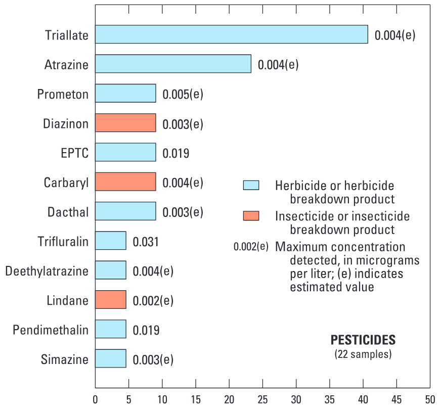
Out of 47 pesticides and 84 VOCs analyzed, 12 pesticides (or pesticide breakdown products) and 15 VOCs were detected (fig. 8) in water samples collected from the Spokane River near Post Falls and at Seven Mile Bridge. Nearly all of the detections were at very low concentrations and none exceeded established USEPA water-quality standards and guidelines.
The herbicide triallate, used on barley and wheat, was detected in 40 percent of 22 water samples collected from the Spokane River during the spring and summer of 1999 and 2000. The herbicide atrazine was the only other pesticide detected in more than 10 percent of the samples. The herbicides EPTC (0.019 μg/L), trifluralin (0.031 μg/L), and pendimethalin (0.019 μg/L) were the only pesticides detected at quantifiable concentrations; all other pesticide detections were reported as estimates because of their extremely low concentration.
VOCs detected in the Spokane River belong to three general classes: fuel-related, trihalomethanes, and solvents. These classes of VOCs are common in storm water and shallow ground water in urban areas across the Nation (Lopes and Bender, 1998). Toluene, benzene, chloroform, and acetone were detected in more than 50 percent of 12 samples collected from the Spokane River during February through October 1999. Similar to pesticide detections in the Spokane River, most VOC detections were reported as estimates because of their low concentrations. MTBE was detected in two samples at a concentration of 0.3 μg/L, well below the 20- to 40-μg/L drinking-water advisory issued by the USEPA (U.S. Environmental Protection Agency, 1997).

Figure 8. Twelve different pesticides and fifteen different VOCs were detected in water samples from the Spokane River. In general, the detections were at extremely low concentrations.
Ground water in aquifers used for drinking-water supply in Spokane, Coeur d’Alene, and Missoula is generally of good quality
Ground water in basin-fill aquifers in the Spokane Valley and surrounding area and the Missoula/Bitterroot Valleys is of good quality and generally acceptable for most purposes (fig. 9). These aquifers serve as principal sources of drinking water (two areas within these aquifers are designated as sole-source aquifers; fig. 10) in northeastern Washington, northern Idaho, and southwestern Montana. These aquifers are highly susceptible to contamination, however, because of agricultural activities and urban development, in combination with permeable overlying soils that allow water and contaminants to readily move downward to the water table.
Major Findings
Even though the basin-fill aquifers are susceptible to contamination, relatively few constituent concentrations exceeded USEPA drinking-water standards and guidelines. The elevated concentrations of trace elements, such as arsenic and radon, in a few of the samples most likely resulted from natural processes rather than human activities. Arsenic, which occurs naturally in rocks and soils, exceeded the USEPA drinking-water standard of 10 μg/L in

Figure 9. Water quality in basin-fill aquifers in the Spokane/Coeur d’Alene area and in the Missoula/Bitterroot Valleys is good. Few constituents exceed established Federal drinking-water standards or guidelines. Alluvial aquifers are susceptible to contamination because of porous soils, shallow depths to water, and relatively rapid rates of recharge.
samples collected from three wells (12 to 31 μg/L) in Spokane/Coeur d’Alene area aquifers (fig. 9). Concentrations of iron and (or) manganese, also naturally occurring minerals, exceeded USEPA secondary drinking-water regulations developed for taste, odor, and aesthetic effects, in five wells in the Spokane/ Coeur d’Alene area aquifers and in one well in the Missoula/Bitterroot Valley aquifers.
Radon concentrations ranged from 253 to 3,050 pCi/L; concentrations in all but one of the samples from 61 wells exceeded the proposed USEPA drinking-water standard of 300 pCi/L (U.S. Environmental Protection Agency, 2000). A less stringent standard has been proposed that would raise the acceptable concentration of radon in individual water systems to 4,000 pCi/L. No samples from the Spokane/Coeur d’Alene area or Missoula/Bitterroot Valley basin-fill aquifers contained radon at concentrations that exceeded this limit. Radon in ground water is related to rock type and typically is elevated in igneous and metamorphic rocks. For example, concentrations in excess of 1,000 pCi/L were measured along the relatively thin margins of the Spokane, Coeur d’Alene, and Bitterroot Valleys, which are underlain by granitic bedrock aquifers.
Nitrate, which is derived primarily from fertilizers used on farmland and residential areas, was found in 90 percent of ground-water samples, but concentrations were low (medians of 0.26 and 0.40 mg/L in the Spokane/ Coeur d’Alene area and Missoula/Bitterroot Valley aquifers). In fact, only seven samples, all from wells in the Spokane/Coeur d’Alene area aquifers, contained concentrations of nitrate of 2 mg/L or greater — a “background” or natural concentration above which possible contamination from human sources is indicated (Mueller and Helsel, 1996). No concentrations exceeded the USEPA drinking-water standard of 10 mg/L; the maximum nitrate concentration of 7.6 mg/L was measured in an agricultural area in the Little Spokane River Valley north of Spokane.
What is Radon?
Radon is a colorless, odorless, radioactive gas that occurs naturally through the radioactive decay of radium in igneous and metamorphic rocks. It commonly enters buildings through foundation cracks, dirt floors, and floor drains and can dissolve in ground water. Radon in ground water is carried into buildings served by water-supply wells, where it is subsequently released into air during everyday use and potentially becomes a cause of lung cancer (U.S. Environmental Protection Agency, 2000). Some States, in cooperation with the USEPA, are developing multimedia mitigation programs to reduce concentrations of radon in indoor air. One of the recommendations of these programs is to limit radon concentrations in individual water systems to 4,000 pCi/L.
Radon concentrations in basin-fill
Radon concentrations in about 90 percent of the groundwater samples collected from the Spokane/Coeur d’Alene area and Missoula/Bitterroot Valley basin-fill aquifers exceeded 420 pCi/L, the NAWQA national median for nearly 2,500 ground-water samples collected from 1991 to 2001. Igneous and metamorphic rocks, which are sources of radon-bearing minerals, are common throughout the Northern Rocky Mountains. Radon is similarly elevated in aquifers in other parts of the Rocky Mountain region such as the Upper
aquifers were among the highest in the Nation Pesticides and volatile organic compounds occur relatively infrequently and at low concentrations in ground water
Pesticides and VOCs were detected relatively infrequently in ground water in the Spokane/Coeur d’Alene area and the Missoula/Bitterroot Valley basin-fill aquifers. Specifically, at least one pesticide compound was detected in 15 wells and at least one VOC was detected in 19 wells. Mixtures of pesticides and VOCs were detected in five wells (fig. 10); however, all concentrations were well below USEPA drinking-water standards and guidelines.
Fourteen different pesticides were detected at least once in the Spokane/ Coeur d’Alene area and the Missoula/ Bitterroot Valley basin-fill aquifers. The most commonly detected compounds were the herbicide prometon (four detections) and the insecticide carbofuran and (or) its breakdown products (five detections). Prometon, used primarily for nonagricultural purposes such as domestic and commercial applications along roadsides and as an asphalt additive, is most common in ground water in urban areas (Kolpin and others, 1998). Prometon is one of the most frequently detected pesticides in ground water nationally (Squillace and others, 2002). Carbofuran (and[or] its breakdown products), which is used on fruits, vegetables, and forests to control a variety of insects, was detected only in an area of heavy agricultural land use in the Little Spokane River Valley north of Spokane. Concentrations of carbofuran were about 1,000 times less than the current USEPA drinking-water standard of 40 μg/L (U.S. Environmental Protection Agency, 2001).
The number of pesticides detected and their concentrations in the Spokane/ Coeur d’Alene area and the Missoula/ Bitterroot Valley basin-fill aquifers generally were less than those in ground water sampled nationwide. Specifically, none of the pesticide concentrations in the basin-fill aquifers exceeded 0.2 μg/L, whereas concentrations in 9 percent of nearly 1,500 NAWQA samples collected from 1992 to 1999 exceeded 0.2 μg/L (Squillace and others, 2002).

Figure 10. Pesticides were detected in 15 of 61 basin-fill aquifer wells in the Spokane/Coeur d’Alene and Missoula/Bitterroot Valleys; VOCs were detected in 19 wells; and both pesticides and VOCs were detected in 5 wells. All of the pesticides and VOCs detected were at concentrations less than USEPA drinking-water standards and guidelines.
Trihalomethanes, a class of compounds that are formed during the disinfection of microbes in drinking water, were among the most frequently detected VOCs and were detected in seven wells. Chloroform, the most common trihalomethane, was detected in five wells; the maximum concentration was 0.54 μg/L. Other frequently detected VOCs included tetrachloroethene (or PERC) and 1,1,1-trichloroethane. These two compounds are used in dry cleaning and as degreasing solvents and were detected in four and three wells, respectively. Although PERC has been detected at concentrations exceeding the 5-μg/L drinking-water standard in
Major Findings
samples collected by Missoula County within the Missoula urban area, concentrations in samples collected during this study (maximum was 0.3 μg/L) were well below the USEPA drinking-water standard. Methyl tert-butyl ether (or MTBE), a gasoline oxygenate of environmental concern, was not detected in ground-water samples during this study. Although MTBE is not used as a fuel additive in the State of Washington, it has been detected in ground water in the Spokane area (Washington State Department of Ecology, 2000a) and in other areas throughout the United States (Delzer and Ivahnenko, 2003).
The NAWQA study design for the Northern Rockies Intermontane Basins includes assessments of the physical and chemical characteristics of surface and ground water and the ecological conditions in streams. Information was collected on stream chemistry and ecology and ground-water chemistry using nationally consistent protocols and methods (Gilliom and others, 1995). Thus, water-quality findings in the Study Unit can be compared with findings in other basins and be placed in a regional and national context.

Stream Chemistry and Ecology
Assessment of stream chemistry focused on how water quality of rivers varies in different seasons, under different hydrologic conditions, and in response to different types of land use. Samples were collected at 10 monitoring sites for about 2 years and were analyzed for major ions, nutrients, trace elements, and suspended sediment. Selected streams were sampled intensively for VOCs and(or) pesticides. Ecological assessments focused on the effects of land use on stream ecology, especially as demonstrated by contaminants in fish tissue and streambed sediment and by the numbers and kinds of aquatic organisms. Fish-tissue and streambed-sediment samples were collected at general stream-chemistry sites and at additional stream sites for a basinwide assessment of trace elements and organic compounds. Special ecological studies were conducted in the Spokane and St. Regis River Basins to evaluate the effects of mining on stream ecology and contaminants in the Spokane River.

Ground-Water Chemistry
Ground-water assessments focused on water quality of two major basin-fill aquifers that are the principal sources of drinking water in their areas and include two areas designated by the USEPA as sole-source aquifers: the Spokane Valley/Rathdrum Prairie aquifer in northeastern Washington and northern Idaho, and the Missoula aquifer in southwestern Montana. These aquifers are highly susceptible to contamination because of agricultural activities and urban development, in combination with permeable overlying soils that allow water and contaminants to readily move downward to the water table. In addition, a ground-water/surface-water interaction study was conducted to examine the effects of recharge from the Spokane River on the hydrologic and chemical characteristics of the adjacent alluvial aquifer.
Study Unit Design Water Quality in the Northern Rockies Intermontane Basins
Andrews, E.D., 1987, Longitudinal dispersion of trace elements in the Clark Fork River, Montana, in Averett, R.C., and McKnight, D.M., eds., Chemical quality of water and the hydrologic cycle: Chelsea, Mich., Lewis Publishers, p. 179–191.
Axtmann, E.V., Cain, D.J., and Luoma, S.N., 1997, Effect of tributary inflows on the distribution of trace elements in fine-grained bed sediments and benthic insects of the Clark Fork River, Montana: Environmental Science and Technology, v. 31, no. 3, p. 750–758.
Beckwith, M.A., 1996, Water-quality data collected during floods in the Coeur d’Alene River, northern Idaho, February 1996: U.S. Geological Survey Fact Sheet FS–219–96, 4 p.
Beckwith, M.A., 2002, Selected trace-element and syntheticorganic compound data for streambed sediment from the Clark Fork-Pend Oreille and Spokane River Basins, Montana, Idaho, and Washington, 1998: U.S. Geological Survey Open-File Report 02–336, 36 p.
Beckwith, M.A., 2003, Summary of surface-water-quality data collected for the Northern Rockies Intermontane Basins National Water-Quality Assessment Program in the Clark Fork-Pend Oreille and Spokane River Basins, Montana, Idaho, and Washington, water years 1999–2001: U.S. Geological Survey Open-File Report 02–472, 47 p.
Bolke, E.L., and Vaccaro, J.J., 1981, Digital-model simulation of the hydrologic flow system, with emphasis on ground water in the Spokane Valley, Washington and Idaho: U.S. Geological Survey Open-File Report 80–1300, 43 p.
Bookstrom, A.A., Box, S.E., Campbell, J.K., Foster, K.I., and Jackson, B.L., 2001, Lead-rich sediments, Coeur d’Alene River Valley, Idaho — Area, volume, tonnage, and lead content: U.S. Geological Survey Open-File Report 01–140, 44 p.
Caldwell, R.R., and Bowers, C.L., 2003, Surface-water/ ground-water interaction of the Spokane River and the Spokane Valley/Rathdrum Prairie aquifer, Idaho and Washington: U.S. Geological Survey Water-Resources Investigations Report 03–4239, 60 p.
Canadian Council of Ministers of the Environment, 1999, Canadian sediment quality guidelines for the protection of aquatic life — Summary tables, in Canadian Environmental Quality Guidelines: Winnipeg, Canada.
Clark, G.M., 2003, Occurrence and transport of cadmium, lead, and zinc in the Spokane River Basin, Idaho and Washington, water years 1999–2001: U.S. Geological Survey Water-Resources Investigations Report 02–4183, 37 p. Clark, G.M., Maret, T.R., Rupert, M.G., Maupin, M.A., Low, W.H., and Ott, D.S., 1998, Water quality in the upper Snake River Basin, Idaho and Wyoming, 1992–95: U.S. Geological Survey Circular 1160, 35 p.
Clark, G.M., Mueller, D.K., and Mast, M.A., 2000, Nutrient concentrations and yields in undeveloped stream basins of the United States: Journal of the American Water Resources Association, v. 36, no. 4, p. 849–860.
Delzer, G.C., and Ivahnenko, T., 2003, Occurrence and temporal variability of methyl tert-butyl ether (MTBE) and other volatile organic compounds in select sources of drinking water — Results of the focused survey: U.S. Geological Survey Water-Resources Investigations Report 02–4084, 65 p.
Ellis, M.M., 1940, Pollution of the Coeur d’Alene River and adjacent waters by mine wastes: Washington, D.C., U.S. Bureau of Fisheries Special Report no. 1 [Available from U.S. Fish and Wildlife Service, Washington, D.C.], 61 p.
Gearhart, C., and Buchanan, J.P., 2000, The hydraulic connection between the Spokane River and the Spokane aquifer — Gaining and losing reaches of the Spokane River from State Line, Idaho to Spokane, Washington: Report prepared for the Spokane County Water Quality Management Program, 109 p.
Gilliom, R.J., Alley, W.M., and Gurtz, M.E., 1995, Design of the National Water-Quality Assessment Program — Occurrence and distribution of water-quality conditions: U.S. Geological Survey Circular 1112, 33 p.
Grosbois, C.A., Horowitz, A.J., Smith, J.J., and Elrick, K.A., 2001, The effect of mining and related activities on the sediment-trace element geochemistry of Lake Coeur d’Alene, Idaho, USA, Part III, Downstream effects — The Spokane River Basin: Hydrological Processes, v. 15, p. 855–875.
Hornig, C.E., Terpening, D.A., and Bogue, M.W., 1988, Coeur d’Alene Basin – EPA water quality monitoring (1972–1986): Seattle, Wash., U.S. Environmental Protection Agency, EPA 910/9–88–216, 14 p., 2 apps.
Horowitz, A.J., Elrick, K.A., and Cook, R.B., 1993, Effect of mining and related activities on the sediment trace element geochemistry of Lake Coeur d’Alene, Idaho, USA, Part I, surface sediments: Hydrological Processes, v. 7, p. 403–423.
Horowitz, A.J., Elrick, K.A., Robbins, J.A., and Cook, R.B., 1995, Effect of mining and related activities on the sediment trace element geochemistry of Lake Coeur d’Alene, Idaho, USA, Part II, subsurface sediments: Hydrological Processes, v. 9, p. 35–54. Kolpin, D.W., Barbash, J.E., and Gilliom, R.J., 1998, Occurrence of pesticides in shallow ground water of the United States — Initial results from the National Water-Quality Assessment Program: Environmental Science and Technology, v. 32, no. 5, p. 558–566.
Lambing, J.H., 1998, Estimated 1996–97 and long-term average annual loads for suspended sediment and selected trace metals in streamflow of the upper Clark Fork Basin from Warm Springs to Missoula, Montana: U.S. Geological Survey Water-Resources Investigations Report 98–4137, 35 p.
Long, K.R., 1998, Production and disposal of mill tailings in the Coeur d’Alene mining region, Shoshone County, Idaho – preliminary estimates: U.S. Geological Survey Open-File Report 98–595, 14 p.
Lopes, T.J., and Bender, D.A., 1998, Nonpoint sources of volatile organic compounds in urban areas — Relative importance of urban land surfaces and air: Environmental Pollution, v. 101, p. 221–230.
MacCoy, D.E., 2001, PCBs in tissue of fish from the Spokane River, Washington, 1999: U.S. Geological Survey Fact Sheet FS–067–01, 6 p.
MacCoy, D.E., and Maret, T.R., 2003, Ecological indicators of water quality in the Spokane River, Idaho and Washington, 1989 and 1999: U.S. Geological Survey Fact Sheet FS–067–03, 8 p.
Maret, T.R., Cain, D.J., MacCoy, D.E., and Short, T.M., 2003, Response of benthic invertebrate assemblages to metals exposure and bioaccumulation associated with hard-rock mining in northwestern streams, U.S.A.: Journal of the North American Benthological Society, v. 22, no. 4, p. 598–620.
Maret, T.R., and Dutton, D.M., 1999, Summary of information on synthetic organic compounds and trace elements in tissue of aquatic biota, Clark Fork-Pend Oreille and Spokane River Basins, Montana, Idaho, and Washington, 1974–96: U.S. Geological Survey Water-Resources Investigations Report 98–4254, 55 p.
Maret, T.R., and MacCoy, D.E., 2002, Fish assemblages and environmental variables associated with hard-rock mining in the Coeur d’Alene River Basin, Idaho: Transactions of the American Fisheries Society, v. 131, no. 5, p. 865–884.
Maret, T.R., and Skinner, K.D., 2000, Concentrations of selected trace elements in fish tissue and streambed sediment in the Clark Fork–Pend Oreille and Spokane River Basins, Washington, Idaho, and Montana, 1998: U.S. Geological Survey Water-Resources Investigations Report 00–4159, 26 p.
References Cited
Marr, J.C.A., Bergman, H.L., Parker, M., Lipton, J., Cacela, D., Erickson, W., and Phillips, G.R., 1995, Relative sensitivity of brown and rainbow trout to pulsed exposures of an acutely lethal mixture of elements typical of the Clark Fork River, Montana: Canadian Journal of Fisheries and Aquatic Sciences, v. 52, p. 2005–2015.
Marti, P.B., and Garrigues, R.S., 2001, Spokane River/Aquifer interaction project results, May–November 1999: Washington State Department of Ecology Report 01–03–024, 40 p.
Mueller, D.K., and Helsel, D.R., 1996, Nutrients in the nation’s waters — Too much of a good thing?: U.S. Geological Survey Circular 1136, 24 p.
Newell, A.J., Johnson, D.W., and Allen, L.K., 1987, Niagara River biota contamination project — Fish flesh criteria for piscivorous wildlife: New York Department of Environmental Conservation, Division of Fish and Wildlife, Bureau of Environmental Protection, Technical Report 87–3, 182 p.
Omernik, J.M., and Gallant, A.L., 1986, Ecoregions of the Pacific Northwest: Corvallis, Oreg., U.S. Environmental Protection Agency EPA/600/3−86/033, 39 p.
Phillips, G.R., and Lipton, J., 1995, Injury to aquatic resources caused by metals in Montana’s Clark Fork River basin — Historic perspective and overview: Canadian Journal of Fisheries and Aquatic Sciences, v. 52, p. 1990–1993.
Spahr, N.E., Apodaca, L.E., Deacon, J.R., Bails, J.B., Bauch, N.J., Smith, C.M., and Driver, N.E., 2000: Water quality in the Upper Colorado River Basin, Colorado, 1996–98: U.S. Geological Survey Circular 1214, 33 p.
Squillace, P.J., Scott, J.C., Moran, M.J., Nolan, B.T., and Kolpin, D.W., 2002, VOCs, pesticides, nitrate, and their mixtures in groundwater used for drinking water in the United States: Environmental Science and Technology, v. 36, no. 9, p. 1923–1930.
Tornes, L.H., 1997, National Water-Quality Assessment Program — Northern Rockies Intermontane Basins: U.S. Geological Survey Fact Sheet FS–158–97, 4 p.
U.S. Census Bureau, 2000, State and county quickfacts: accessed December 2001 at URL http://quickfacts.census.gov/qfd.
U.S. Environmental Protection Agency, 1997, Drinking water advisory — Consumer acceptability advice and health effects analysis on methyl tertiary-butyl ether (MTBE): EPA822–F—97–009, Office of Water, 34 p.
U.S. Environmental Protection Agency, 1999, Water quality standards; establishment of numeric criteria for priority toxic pollutants; States’ compliance — Revision of polychlorinated biphenyls (PCBs) criteria; final rule: Federal Register, 40 CFR, Part 131, p. 61182–61196.
U.S. Environmental Protection Agency, 2000, Proposed radon in drinking water rule: EPA 815–F—99–009, updated April 2000: accessed December 2001 at URL http://www.epa.gov/safewater/radon/proposal.html.
U.S. Environmental Protection Agency, 2001, List of drinking water contaminants & MCLs: accessed December 2001 at URL http://www.epa.gov/safewater/mcl.html.
Washington State Department of Ecology, 1995, Department of Ecology 1993–94 investigation of PCBs in the Spokane River: Olympia, Wash., Toxic Investigations Section, Environmental Investigations and Laboratory Services Program, Publication no. 95–310, 54 p., 5 apps.
Washington State Department of Ecology, 2000a, Occurrence of methyl tertiary-butyl ether (MTBE) in groundwater at leaking underground storage tank sites in Washington: Olympia, Publication no. 00–09–054, 23 p.
Washington State Department of Ecology, 2000b, 2000 Washington State water quality assessment, section 305(b) report: Olympia, Wash., Water Division, Publication no. 00–10–058, 179 p.
Watson, V.J., Ingman, G., and Anderson, B., 2000, Clark Fork River — Scientific basis of a nutrient TMDL for a river of the northern Rockies, in Nutrient criteria technical guidance manual, rivers and streams: Washington, D.C., U.S. Environmental Protection Agency, EPA 822–B—00–002.
Welch, E.B., Horner, R.R., and Patmont, C.R., 1989, Prediction of nuisance periphytic biomass — A management approach: Water Resources, v. 23, no. 4, p. 401–405.
Wiener, J.G., and Spry, D.J., 1996, Toxicological significance of mercury in freshwater fish, in Beyer, W.N., Heinz, G.H., and Redmon-Norwood, A.W., eds., Environmental contaminants in wildlife: Boca Raton, Fla., CRC Press, p. 265–279.
Woods, P.F., 2001, Concentrations and loads of cadmium, lead, and zinc on the ascending and descending limbs of the 1999 snowmelt-runoff hydrographs for nine water-quality stations, Coeur d’Alene River Basin, Idaho: U.S. Geological Survey Open-File Report 00–310, 41 p.
Woods, P.F., in press, Role of limnological processes in fate and transport of nitrogen and phosphorus loads delivered into Coeur d’Alene Lake and Lake Pend Oreille, Idaho, and Flathead Lake, Montana: U.S. Geological Survey Professional Paper 1682, 44 p. Woods, P.F., and Beckwith, M.A., 1997, Nutrient and trace-element enrichment of Coeur d’Alene Lake, Idaho: U.S. Geological Survey Water-Supply Paper 2485, 93 p.
Woodward, D.F., Farag, A.M., Bergman, H.L., DeLonay, A.J., Little, E.E., Smith, C.E., and Barrows, F.T., 1995, Metalscontaminated benthic invertebrates in the Clark Fork River, Montana — Effects on age-0 brown trout and rainbow trout: Canadian Journal of Fisheries and Aquatic Sciences, v. 52, p. 1994–2004. Alluvial aquifer - A water-bearing deposit of unconsolidated material (sand and gravel) left behind by a river or other flowing water. Aquatic-life criteria - Water-quality guidelines for protection of aquatic life. Often refers to U.S. Environmental Protection Agency water-quality criteria for protection of aquatic organisms. See also Water-quality guidelines and Water-quality criteria. Background concentration - A concentration of a substance in a particular environment that is indicative of minimal influence by human (anthropogenic) sources. Bedrock - General term for consolidated (solid) rock that underlies soils or other unconsolidated material. Bed sediment - The material that temporarily is stationary in the bottom of a stream or other watercourse. Benthic invertebrates - Insects, mollusks, crustaceans, worms, and other organisms without a backbone that live in, on, or near the bottom of lakes, streams, or oceans. Bioaccumulation - The net accumulation of a substance by an organism as a result of uptake from all environmental sources, including gills, epithelial tissues, and dietary sources. Breakdown product - A compound derived by chemical, biological, or physical action upon a pesticide. The breakdown is a natural process that may result in a more toxic or a less toxic compound and a more persistent or less persistent compound. Concentration - The amount or mass of a substance present in a given volume or mass of sample. Usually expressed as micrograms per liter (water sample) or micrograms per kilogram (sediment or tissue sample).
Cubic foot per second (ft/s, or cfs) - Rate of water discharge
representing a volume of 1 cubic foot passing a given point during 1 second, equivalent to approximately 7.48 gallons per second or 448.8 gallons per minute or 0.02832 cubic meter per second. Detection limit - The minimum concentration of a substance that can be identified, measured, and reported within 99-percent confidence that the analyte concentration is greater than zero; determined from analysis of a sample in a given matrix containing the analyte. Discharge - Rate of fluid flow passing a given point at a given moment in time, expressed as volume per unit of time. Dissolved constituent - Operationally defined as a constituent in water that passes through a 0.45-micrometer filter. Drainage area - The drainage area of a stream at a specified location is that area, measured in a horizontal plane, which is enclosed by a drainage divide.
Drinking-water standard or guideline - A threshold concen-
tration in a public drinking-water supply, designed to protect human health. As defined here, standards are U.S. Environmental Protection Agency regulations that specify the maximum contaminant levels for public water systems required to protect the public welfare; guidelines have no regulatory status and are issued in an advisory capacity. Eutrophication - The process by which water becomes enriched with plant nutrients, most commonly phosphorus and nitrogen. Ground water - In general, any water that exists beneath the land surface, but more commonly applied to water in fully saturated soils and geologic formations. Herbicide - A chemical or other agent applied for the purpose of killing undesirable plants. See also Pesticide. Human health advisory - Guidance provided by U.S. Environmental Protection Agency, State agencies, or scientific organizations, in the absence of regulatory limits, to describe acceptable contaminant levels in drinking water or edible fish. Insecticide - A substance or mixture of substances intended to destroy or repel insects. Load - General term that refers to a material or constituent in solution, in suspension, or in transport; usually expressed in terms of mass or volume.
Maximum contaminant level (MCL) - Maximum permissible
level of a contaminant in water that is delivered to any user of a public water system. MCLs are enforceable standards established by the U.S. Environmental Protection Agency. Mean - The average of a set of observations, unless otherwise specified. Median - The middle or central value in a distribution of data ranked in order of magnitude. The median is also known as the 50th percentile. Micrograms per liter (μg/L) - A unit expressing the concentration of constituents in solution as weight (micrograms) of solute per unit volume (liter) of water; equivalent to one part per billion in most streamwater and ground water. One thousand micrograms per liter equals 1 mg/L.
Milligrams per liter (mg/L) - A unit expressing the concen-
tration of chemical constituents in solution as weight (milligrams) of solute per unit volume (liter) of water; equivalent to one part per million in most streamwater and ground water. One thousand micrograms per liter equals 1 mg/L. Minimum Reporting Level - Smallest measured concentration of a constituent that may be reliably reported using a given analytical method.
Nutrient - Element or compound essential for animal and plant growth. Common nutrients in fertilizer include nitrogen, phosphorus, and potassium. Organochlorine compound - Synthetic organic compounds containing chlorine. As generally used, term refers to compounds containing mostly or exclusively carbon, hydrogen, and chlorine. Examples include organochlorine insecticides, polychlorinated biphenyls, and some solvents containing chlorine. Pesticide - A chemical applied to crops, rights of way, lawns, or residences to control weeds, insects, fungi, nematodes, rodents, or other “pests.” Picocurie (pCi) - One trillionth (10-12) of the amount of radioactivity represented by a curie (Ci). A curie is the amount of radioactivity that yields 3.7 x 10 radioactive disintegrations per second (dps). A picocurie yields 2.22 disintegrations per minute (dpm), or 0.037 dps.
Polychlorinated biphenyls (PCBs) - A mixture of chlorinated
derivatives of biphenyl, marketed under the trade name Aroclor with a number designating the chlorine content (such as Aroclor 1260). PCBs were used in transformers and capacitors for insulating purposes and in gas pipeline systems as a lubricant. Further sale for new use was banned by law in 1979. Probable effect level (PEL) - A guideline established by the Canadian Council of Ministers of the Environment for the protection of aquatic life in streambed sediment. According to the guideline, trace-element concentrations in bulk sediment exceeding the PEL frequently are associated with adverse biological effects. Radon - A naturally occurring, colorless, odorless, radioactive gas formed by the disintegration of the element radium; damaging to human lungs when inhaled. Runoff - Excess rainwater or snowmelt that is transported to streams by overland flow, tile drains, or ground water. Sole-source aquifer - A ground-water system that supplies at least 50 percent of the drinking water to a particular human population; the term is used to denote special protection requirements under the Safe Drinking Water Act and may be used only by approval of the U.S. Environmental Protection Agency. Streamflow - A type of channel flow applied to that part of surface runoff in a stream, whether or not it is affected by diversion or regulation. Synoptic - A short-term investigation of specific water-quality conditions during selected seasonal or hydrologic conditions to provide improved spatial resolution for critical water-quality conditions. Tailings - Rock that remains after processing ore to remove the valuable minerals.
Total Maximum Daily Load (TMDL) - The amount of a particu-
lar pollutant that a particular stream, lake, estuary, or other water body can ‘handle’ without violating State water-quality standards. Trace element - An element found in only minor amounts (concentrations less than 1.0 milligram per liter) in water or sediment; includes arsenic, cadmium, chromium, copper, lead, mercury, nickel, and zinc. Tributary - A river or stream flowing into a larger river, stream, or lake. Urban site - A site that has greater than 50 percent urbanized and less than 25 percent agricultural area.
Volatile organic compounds (VOCs) - Organic chemicals that
have a high vapor pressure relative to their water solubility. VOCs include components of gasoline, fuel oils, and lubricants, as well as organic solvents, refrigerants, fumigants, some inert ingredients in pesticides, and some byproducts of chlorine disinfection. Water-quality criteria - Specific levels of water quality which, if reached, are expected to render a body of water unsuitable for its designated use. Commonly refers to water-quality criteria established by the U.S. Environmental Protection Agency. Water-quality criteria are based on specific levels of pollutants that would make the water harmful if used for drinking, swimming, farming, fish production, or industrial processes. Water-quality guidelines - Specific levels of water quality which, if reached, may adversely affect human health or aquatic life. These are nonenforceable guidelines issued by a governmental agency or other institution. Water-quality standards - State-adopted and U.S. Environmental Protection Agency-approved ambient standards for water bodies. Standards include the use of the water body and the water-quality criteria that must be met to protect the designated use or uses. Water year - The continuous 12-month period, October 1 through September 30, in U.S. Geological Survey reports dealing with surface-water supply. The water year is designated by the calendar year in which it ends and which includes 9 of the 12 months. Thus, the year ending September 30, 1980, is referred to as water year 1980. Yield - The mass of material or constituent transported by a river in a specified period of time, divided by the drainage area of the river basin.
Appendix


������������������������������������������ Appendix Water Quality in the Northern Rockies Intermontane Basins


������������


Coordination with agencies and organizations in the Northern Rockies Intermontane Basins was integral to the success of this water-quality assessment. We thank those who served as members of our liaison committee.
Federal Agencies Bureau of Indian Affairs National Park Service U.S Army Corps of Engineers U.S. Bureau of Land Management U.S. Environmental Protection Agency U.S. Fish and Wildlife Service U.S. Forest Service
State Agencies Idaho Department of Environmental Quality Idaho Department of Water Rescources Idaho Fish and Game Montana Bureau of Mines Montana Department of Environmental Quality Montana Fish, Wildlife, and Parks Washington Department of Ecology Washington Department of Fish and Wildlife Washington Department of Natural Resources
We thank the following individuals for contributing to this effort.
Lan Tornes for his early efforts in getting this project up and running.
Rick Backsen, Fred Bailey, Lee Chambers, Lawrence Deweese, Angela Frandsen, Keith Hein, Dorene MacCoy, Doug Ott, Karen Payne, Stephan Porter, Ken Skinner, Terry Short, and Zachary Taylor for their assistance in data collection.
John Lambing, John Roland, and Michael Woodside for their technical reviews of the manuscript.
Richard Helton and Phillip Redman for preparation of illustrations.
Linda Channel for editorial reviews and report processing.
The numerous property owners that allowed the use of their property by the USGS for access to specific stream reaches, the installation of monitoing wells, or the sampling of existing wells. Local Agencies City of Missoula Panhandle Health District Spokane County Spokane County Conservation District
Universities Eastern Washington University Montana State University University of Idaho University of Montana
Other public and private organizations Clark Fork - Pend Oreille Coalition Coeur d’Alene Tribe Confederated Salish and Kootenai Tribe Flathead Basin Commission Silver Valley Natural Resources Trustees Spokane River Association Tri-State Water Quality Council Kalispel Tribe

U.S. Geological Survey Circular 1235
Where this page came from
This page was imported from U.S. Geological Survey. Published by the U.S. Geological Survey and, as a work of the United States government, in the public domain.
Nobody has written it yet — it is the source material at a new address, which is why search engines are asked to skip it and why no one earns from it. It is up for grabs: take it on, and it is yours to rewrite and to earn from.
Licence: CC0 1.0 (public domain) · Adapted from pubs.usgs.gov
1
0
0
0

Comments


