
Want to improve the page's content? Try to propose a change.
On This Page Navigation
Geodiversity refers to the full variety of natural geologic (rocks, minerals, sediments, fossils, landforms, and physical processes) and soil resources and processes that occur in the park. A product of the Geologic Resources Inventory, the NPS Geodiversity Atlas delivers information in support of education, Geoconservation, and integrated management of living (biotic) and non-living (abiotic) components of the ecosystem.

In-depth geologic information is contained in the baseline inventory products of the Geologic Resources Inventory, see table below.
Geologic Features and Processes
While much of the geologic history of the Precambrian, Paleozoic and Mesozoic eras is absent in Chiricahua National Monument, the rocks that are exposed record a dynamic Cenozoic history of volcanic eruptions. Remnants of the Turkey Creek caldera provide evidence for three successive large volcanic eruptions beginning about 26.9 million years ago that blasted more than 400 km3 (100 mi3) of magma from a buried magma chamber and covered a region of at least 3,100 km2 (1,200 mi2) with pyroclastic debris. Volcanic ash, glowing gas cloud deposits, steam vents, lava flows, and high velocity surge deposits can be found in Chiricahua National Monument. Hot glass shards fused together to form the welded tuff of the Rhyolite Canyon Tuff, a deposit at least 490 m (1,600 ft) thick. Upon cooling, vertical joints formed in the erosion-resistant Rhyolite Canyon Tuff and provided conduits for water. Continual freezing and thawing expanded the joints and dislodged pieces of the rock. Over time, chemical and physical weathering processes acted together to carve the pinnacles, spires, and columns for which the Monument is known.
The geologic features preserved in Chiricahua National Monument are spectacular examples of physical and chemical weathering processes. The Monument was established in 1924 to protect its distinctive pinnacles, columns, spires, and balanced rocks that seem to defy gravity. The remarkable rock spires, known as ‘hoodoos,’ are erosional features formed in the Rhyolite Canyon Tuff. The volcanic eruption that produced the abundant Rhyolite Canyon Tuff ejected more than a thousand times the amount of material than was ejected during the May 1980 Mount St. Helens eruption in Washington State. The explosion and collapse of the magma chamber formed the giant Turkey Creek caldera, a depression 19 km (12 mi) across and 1,500 m (5,000 ft) deep. In addition to the unusual erosional features, Chiricahua National Monument preserves and protects geologically significant remnants of the Turkey Creek caldera.
Features associated with volcanic activity, regional tectonic deformation, and weathering processes are displayed in Chiricahua National Monument. Weathering and erosion processes have created
Slot Canyons
Slumps
Natural Bridge
Solution Pans
Rock Varnish
Tafoni
Spherulites
Inverted Topography
And, the Monument’s distinctive geologic features:
Pinnacles
Spires
Balanced Rocks
Columns
Volcanic features, primarily related to the Turkey Creek caldera, include:
The Caldera
Welded Tuff (Rhyolite Canyon Tuff)
Fiamme
Fumarole Pipes
Moat Deposits
Surge Deposits
Igneous Dikes
Also see, Geolgic Resources Inventory Report for more information on the park's geologic features.
Paleontological Resources
Fossils have been reported from several units at the Monument. Fossil brachiopods, echinoids spines, and gastropods are abundant in the Concha Limestone, Colina Limestone, Epitaph Dolomite, Earp Formation, and Horquilla Limestone.
The Colina Limestone in the Monument fossils includes bryozoans, brachiopods, pelecypods, gastropods, and echinoids. The Concha Limestone fossil assemblage includes the remains of fusulinid foraminifera, sponges, corals, bryozoans, brachiopods, gastropods, scaphopods, pelecypods, ammonoid cephalopods, echinoids, and crinoids.
All NPS fossil resources are protected under the Paleontological Resources Preservation Act of 2009 (Public Law 111-11, Title VI, Subtitle D; 16 U.S.C. §§ 470aaa - 470aaa-11).
Regional Geology
Chiricahua National Monument is a part of the Basin and Range Physiographic Province and shares its geologic history and some characteristic geologic formations with a region that extends well beyond park boundaries.
Maps and Reports
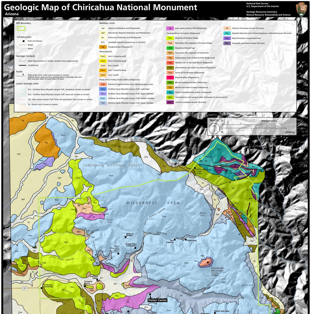
###
Geologic Resources Inventory
The Geologic Resources Inventory produces digital geologic maps and reports for more than 270 natural resource parks. The products listed below are currently available for this park, check back often for updates as many maps, reports, and posters are still in progress.
Scoping summaries are records of scoping meetings where NPS staff and local geologists determined the park’s geologic mapping plan and what content should be included in the report.
- Digital geologic maps include files for viewing in GIS software, a guide to using the data, and a document with ancillary map information. Newer products also include data viewable in Google Earth and online map services.
- Reports use the maps to discuss the park’s setting and significance, notable geologic features and processes, geologic resource management issues, and geologic history.
- Posters are a static view of the GIS data in PDF format. Newer posters include aerial imagery or shaded relief and other park information. They are also included with the reports.
- Projects list basic information about the program and all products available for a park.
Source:
[
NPS DataStore Saved Search 2789
](https://irma.nps.gov/DataStore/SavedSearch/Profile/2789)
. To search for additional information, visit the
NPS DataStore.
###
Soil Resources inventory
A NPS Soil Resources Inventory project has not been completed for Chiricahua National Monument. General information can be found on the NPS Data Store.
Source:
[
NPS DataStore Saved Search 2845
](https://irma.nps.gov/DataStore/SavedSearch/Profile/2845)
. To search for additional information, visit the
NPS DataStore.
Related Links
Chiricahua—Natural features and Ecosystems
Chiricahua—Geologic Formations
NPS—Arid and Semi-arid Region Landforms
NPS—Volcanic Landforms: Extrusive Igneous
Chiricahua National Monument
Narrow By Location
Narrow By Office
Show
10
40
Sort by
Relevance
Recently Updated
Date Released
Title
Loading results...
Tags:
geodiversity
,
geologic
,
[geologic forces](/media/article-search.htm?q=geologic forces)
,
[geologic resources](/media/article-search.htm?q=geologic resources)
,
[geologic feature](/media/article-search.htm?q=geologic feature)
,
[geologic time](/media/article-search.htm?q=geologic time)
,
[geologic layers](/media/article-search.htm?q=geologic layers)
,
[geologic history](/media/article-search.htm?q=geologic history)
,
[geologic formations](/media/article-search.htm?q=geologic formations)
,
geology
,
geological
,
[geological maps](/media/article-search.htm?q=geological maps)
,
geologist
,
[geology talk](/media/article-search.htm?q=geology talk)
,
[geology hike](/media/article-search.htm?q=geology hike)
,
[geology science and learning](/media/article-search.htm?q=geology science and learning)
,
geologists
,
[geology close up](/media/article-search.htm?q=geology close up)
,
[geologic resources inventory](/media/article-search.htm?q=geologic resources inventory)
,
geoheritage
,
geohazards
,
geomorphology
,
[geoscientists in parks](/media/article-search.htm?q=Geoscientists in Parks)
,
geoscientists-in-the-parks
,
[geological survey](/media/article-search.htm?q=Geological Survey)
,
geothermal
,
[geothermal activity](/media/article-search.htm?q=geothermal activity)
,
geotour
,
geotourism
,
[geothermal processes & features](/media/article-search.htm?q=geothermal processes & features)
,
fossils
,
paleontology
,
caves
,
karst
,
glaciers
,
[geoheritage sites](/media/article-search.htm?q=geoheritage sites)
,
earthquakes
,
landslides
,
mining
National Park Service Geodiversity Atlas
The servicewide Geodiversity Atlas provides information on geoheritage and geodiversity resources and values within the National Park System. This information supports science-based geoconservation and interpretation in the NPS, as well as STEM education in schools, museums, and field camps. The NPS Geologic Resources Division and many parks work with National and International geoconservation communities to ensure that NPS abiotic resources are managed using the highest standards and best practices available.
Where this belongs
- Chiricahua National Monument
Where this page came from
This page was imported from National Park Service. Produced by the U.S. National Park Service and, as a work of the United States government, in the public domain.
Nobody has written it yet — it is the source material at a new address, which is why search engines are asked to skip it and why no one earns from it. It is up for grabs: take it on, and it is yours to rewrite and to earn from.
In these collectionsChiricahua National Monument
Licence: CC0 1.0 (public domain) · Adapted from www.nps.gov
1
0
0
0

Comments
Read next


