¿Ves algo que mejorar? Propón un cambio.

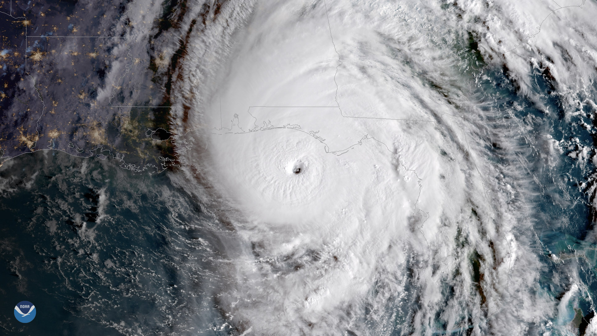
Download Image Download Image of Hurricane Michael
Michael is now a “potentially catastrophic” Category 4 hurricane as it continues barrelling toward the Florida Panhandle, according to the National Hurricane Center (NHC). This GOES East satellite imagery, captured at 9 a.m. ET on Wednesday, Oct. 10, 2018, shows the storm less than 90 miles southwest of Panama City, Florida. Life-threatening storm surge, hurricane-force winds and heavy rainfall are imminent, according to the NHC.
The storm is forecast to move ashore over the Florida Panhandle later on Wednesday, but the NHC warns that some additional strengthening is possible before landfall. The latest data from an Air Force Reserve Hurricane Hunter aircraft indicate that maximum sustained winds have increased to 145 mph, with hurricane-force winds extending outward up to 45 miles from Michael’s center.
A hurricane warning, which is typically issued 36 hours before the anticipated first occurrence of tropical-storm-force winds, is in effect for the Alabama/Florida border to the Suwannee River. The NHC has also issued a storm surge warning for Florida’s Okaloosa/Walton County line to Anclote River, Florida and a storm surge watch for Anclote River, Florida, to Anna Maria Island Florida, including Tampa Bay.
The NHC said water has the potential to reach the following heights if peak surge happens during high tide:
- Tyndall Air Force Base to Aucilla River, Florida: 9-14 feet
- Okaloosa/Walton County line to Tyndall Air Force Base, Florida: 6-9 feet
- Aucilla River to Cedar Key, Florida: 6-9 feet
- Cedar Key to Chassahowitzka, Florida: 4-6 feet
- Chassahowitzka to Anna Maria Island, Florida, including Tampa Bay: 2-4 feet
Rainfall totals of 4 to 8 inches are expected from the Florida Panhandle and Big Bend to southeast Alabama, and portions of southwest and central Georgia. The NHC warns that some areas could see up to a foot of rain. As Michael moves across the southeastern U.S., it could bring 3 to 6 inches of rain to the remainder of Georgia, the Carolinas and southern Virginia. The rest of the Florida Peninsula, the eastern Mid-Atlantic and southern New England could see anywhere from 1 to 3 inches.
This geocolor-enhanced imagery was created by NOAA's partners at the Cooperative Institute for Research in the Atmosphere. The GOES East geostationary satellite, also known as GOES-16, provides coverage of the Western Hemisphere, including the United States, the Atlantic Ocean and the eastern Pacific. The satellite's high-resolution imagery provides optimal viewing of severe weather events, including thunderstorms, tropical storms and hurricanes.
Where this page came from
This page was imported from NOAA Satellites (NESDIS). Published by NOAA's National Environmental Satellite, Data, and Information Service and, as a work of the United States government, in the public domain; pictures credited elsewhere are left out.
Nobody has written it yet — it is the source material at a new address, which is why search engines are asked to skip it and why no one earns from it. It is up for grabs: take it on, and it is yours to rewrite and to earn from.
Licencia: CC0 1.0 (dominio público) · Adaptado de www.nesdis.noaa.gov
1
0
0
0

Comentarios