¿Ves algo que mejorar? Propón un cambio.
Assessment of Undiscovered Oil and Gas Resources of the Central Burma Basin and the Irrawaddy–Andaman and Indo-Burman Geologic Provinces, Myanmar
The Irrawaddy–Andaman and Indo-Burman Geologic Provinces were recently assessed for undiscovered technically recoverable oil, natural gas, and natural gas liquids resources as part of the U.S. Geological Survey’s (USGS) World Oil and Gas Assessment. Using a geology-based assessment methodology, the USGS estimated mean volumes of 2.3 billion barrels of oil, 79.6 trillion cubic feet of gas, and 2.1 billion barrels of natrual gas liquids.
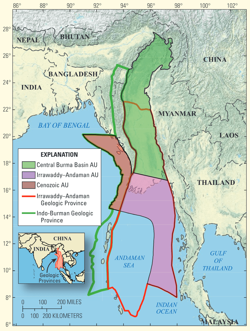
Figure 1. Assessed areas of Myanmar were defined as three composite assessment units (AU) (outlined in black). These are the Central Burma Basin AU (80480101), Irrawaddy–Andaman AU (80480102), and Cenozoic AU (80050101).
Introduction
The U.S. Geological Survey (USGS) World Petroleum Resources Project assesses the potential for undiscovered, technically recoverable oil and natural gas resources of the world, exclusive of the United States. As a part of this program, the USGS recently completed an assessment of the onshore and offshore areas of the Central Burma Basin and the Irrawaddy–Andaman and Indo-Burman Geologic Provinces (fig. 1). This assessment was based on data from oil and gas exploration and production wells, production data, and published geologic reports. Only conventional oil and gas resources were assessed. –
Central Burma Basin Assessment Unit
The Central Burma Basin assessment unit (AU) encompasses an area of 242,000 km in the Central Burma Basin and includes source, reservoir, and seal rocks predominately of Eocene to Miocene age, although Upper Cretaceous and Paleocene source rocks also may contribute to the AU. The basin is an Eocene back arc basin formed by oblique collision of oceanic and continental plates and filled with sediments of a restricted marine environment overlain by sediments of a southward-prograding delta and alluvial system. Compression and folding developed anticlines and faulted anticlines intermittently from Oligocene to present (U.S. Geological Survey World Energy Assessment Team, 2000). Traps are primarily anticlines and stratigraphic traps including pinchouts. Eleven oil and nine gas fields greater than the minimum assessed size of 5 million barrels of oil equivalent (MMBOE) (grown or maximum expected recovery) have been discovered in the Central Burma Basin AU (IHS Energy, 2010).
Irrawaddy–Andaman Assessment Unit
The Irrawaddy–Andaman AU includes an area of 226,000 km and includes source, reservoir, and seal rocks primarily of Eocene to Miocene age. It is the southward extension of the Central Burma Basin with a similar geologic setting and tectonic history; however, the effects of compression caused by plate collision are less evident, whereas the oblique or strike-slip component becomes more dominant. The features distinguishing the Irrawaddy– Andaman AU from the Central Burma Basin AU are that the source and reservoir rocks were deposited in a predominately deltaic and marine environment, and source rocks are more gas prone. Source rock burial depths become greater to the south, and cracking of oil to gas because of greater depths of burial may contribute to this AU being more gas prone. Traps are primarily anticlines, alluvial channels, deltaic features, and carbonate reefs and pinnacles (Wandrey, 2006). Twenty-two gas fields greater than the minimum assessed size of 5 MMBOE (grown) have been discovered (IHS Energy, 2010).
Cenozoic Assessment Unit
The Cenozoic AU encompasses an area of 71,000 km and includes source, reservoir, and seal rocks primarily of Eocene to Pliocene age. The AU includes the Rahkine Basin and occupies the eastern abyssal plain of the Bay of Bengal and part of the accretionary wedge created by oblique subduction of the Indian Plate beneath the Burmese Plate. Source rocks are postulated to be middle to late Eocene shales. Reservoirs are Oligocene-Miocene thick sheet sandstones and turbidites sourced by the Bengal fan, Miocene-Pliocene turbidites, and aggraded lower-slope channel sandstones sourced by the younger Rahkine-Yoma fan. Three gas fields greater than the minimum assessed size of 5 MMBOE (grown) have been discovered (IHS Energy, 2010).

Resource Summary
The USGS geology-based assessment of the undiscovered technically recoverable oil, natural gas, and natural gas liquids resources in the Central Burma Basin and the Irrawaddy–Andaman and Indo-Burman Geologic Provinces resulted in estimated undiscovered mean volumes of 2.3 billion barrels of oil, 79.6 trillion cubic feet of gas, and 2.1 billion barrels of natrual gas liquids.
References Cited
IHS Energy, 2010, International petroleum exploration and production database [current through December 2010]: Available from IHS Energy, 15 Inverness Way East, Englewood, CO 80112.
U.S. Geological Survey World Energy Assessment Team, 2000, U.S. Geological Survey World Petroleum Assessment 2000― Description and results: U.S. Geological Survey Digital Data Series DDS-60, 4 CD ROMS.
Wandrey, C.J., 2006, Eocene to Miocene composite total petroleum system, Irrawaddy–Andaman and North Burma Geologic Provinces, Myanmar, chap. E in Wandrey, C.J., ed., Petroleum systems and related geologic studies in Region 8, South Asia: U.S. geological Survey Bulletin 2208-E, 26 p.
For Additional Information
Assessment results are available at the USGS Central Energy Resources Science Center website: http://energy.cr.usgs.gov/oilgas/ or contact Craig J. Wandrey, the assessing geologist (cwandrey@usgs.gov).
Central Burma Basin and the Irrawadddy–Andaman and Indo-Burman Geologic Provinces Assessment Team
Craig J. Wandrey, Christopher J. Schenk, Timothy R. Klett, Michael E. Brownfield, Ronald R. Charpentier, Troy A. Cook, Richard M. Pollastro, and Marilyn E. Tennyson.
Where this page came from
This page was imported from U.S. Geological Survey. Published by the U.S. Geological Survey and, as a work of the United States government, in the public domain.
Nobody has written it yet — it is the source material at a new address, which is why search engines are asked to skip it and why no one earns from it. It is up for grabs: take it on, and it is yours to rewrite and to earn from.
Licencia: CC0 1.0 (dominio público) · Adaptado de pubs.usgs.gov
1
0
0
0

Comentarios