
Envie d’améliorer le contenu de la page ? Proposez une modification.
Three-quarters of Fire Island National Seashore is underwater — about 8,000 football fields of seafloor in Great South Bay and the Atlantic. Until recently nobody had mapped it. Park managers had "a general sense" of what was down there, in the words of the oceanographer leading the survey, and that was all. After Hurricane Sandy, that gap mattered.

Monique LaFrance aboard the research vessel. NPS
Four parks, mostly submerged
Fire Island is one of four coastal national parks where a team from the University of Rhode Island's Graduate School of Oceanography is mapping underwater habitat for the National Park Service:
| Park | State |
|---|---|
| Fire Island National Seashore | New York |
| Gateway National Recreation Area | New York and New Jersey |
| Cape Cod National Seashore | Massachusetts |
| Assateague Island National Seashore | Maryland |
At three of them — Fire Island, Gateway and Assateague — more than half the park is underwater. That submerged half is seagrass beds, shellfish beds, boulder fields, mud flats, sand waves and ripples. Many are full of life; others could be again. Their shape and makeup matter directly to species that are important for fishing, recreation and the ecosystem. "Almost none of the National Seashores have habitat-mapping data for their parks," says Dr. John King, the URI professor who leads the project and runs its Coastal Mapping Lab.

Salt marsh on Great South Bay, Fire Island National Seashore. LaFrance / NPS
Why now
The bay has lost its seafloor before without anyone being able to measure it. In the mid-1980s brown tides wiped out Great South Bay's eelgrass and the shellfish that depended on it, and a thriving local shellfish industry collapsed almost overnight. What the bottom had looked like beforehand was known only in generalities.
Twenty-seven years after that first brown tide, in October 2012, Hurricane Sandy hit. Its damage above water at Fire Island was plain: breaches through the island, flattened dunes, fallen trees, flooded buildings, wrecked boardwalks. Below water, no one could say what had changed, because no baseline existed.
After Sandy the Department of the Interior put more than $300 million into projects to make coastal habitats and infrastructure more resilient. Some of it paid for this mapping, so that when the next storm comes the parks can see exactly what it did.
How the mapping works

The survey boat, a 28-foot pontoon. LaFrance / NPS
The team works from an open 28-foot pontoon boat, setting up about an hour before dawn, surveying for twelve hours at five knots or less, and spending another hour each evening packing everything away, since the boat has nowhere to stow gear.
They drive in straight, slightly overlapping lines, like mowing a lawn, so that every square inch of the survey area is covered. The instrument is an interferometric side-scan sonar, which sends out pulses of sound and listens to what comes back:
| Bottom | Echo |
|---|---|
| mud | soaks up most of the sound — a weak return |
| boulder | bounces it back almost whole — a strong return |

The sonar scanning a sandy bottom at Fire Island. LaFrance / NPS
A computer on board turns the echoes into pictures instantly. "You get to see new things that people didn't really know about before," says Monique LaFrance, the URI doctoral student who manages the fieldwork at Fire Island and helps coordinate the teams at the other three parks. In the Great South Bay images she can pick out trawl scars from fishing boats and the circular marks left by shellfishing operations from before the collapse.
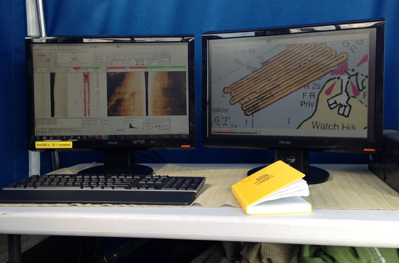
Sonar returns turned into images on board. LaFrance / NPS
Checking against the real thing
Sonar only shows shapes and textures, so the team also takes grab samples: a jaw-like scoop brings up sediment and whatever lives in it. The researchers measure the grain size, then sieve out the animals — worms, shellfish, sand dollars, amphipods — and identify them one by one, thousands in all.

LaFrance examines a seafloor sample. NPS
LaFrance first tried habitat mapping eight years earlier as an undergraduate summer intern in King's lab. "I had no idea what this field was at all," she says. "It just sounded interesting." Now she hires undergraduate interns of her own.

A string of mussels from the bay floor. NPS
What the maps are for
The maps will show managers which areas to protect, which to open for shellfishing or recreation, and which need restoring. And they are a baseline. "In the event of another hurricane or some other disturbance event," LaFrance says, "the next stage of research can focus on what's changed between now and then." Storms and rising seas are among the few certainties a coastal park has; the maps are how these four will know what they lost, and what came back.
Sources
Written from "Sounding Seafloor Habitats: Researchers use sonar to map the underwater resources of four National Parks", by Jamie Remillard and Caroline Gottschalk Druschke (SEAcomm, University of Rhode Island), published by the National Park Service Northeast Coastal and Barrier Network. A PDF of the original is on the NPS DataStore.
Dans ces collectionsAssateague Island National SeashoreFire Island National SeashoreGateway National Recreation AreaCape Cod National Seashore
Licence : CC0 1.0 (domaine public) · Adapté de www.nps.gov
1
0
0
0

commentaires
À lire ensuite


