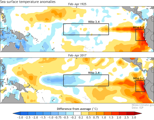
There are many excellent ENSO forecasters around the world who are responsible for providing assessments on the state of El Niño and La Niña for their respective governments. One of my favorite international colleagues is Dr. Ken Takahashi (Instituto Geofísico del Perú) who coordinated the ENSO team in Peru in 2015-16. We just collaborated on a retrospective examination on the 2015-16 El Niño, which will be published in July 2017 (for a pre-print click here). Now we’re faced with an entirely new situation… the potential of a new El Niño in 2017. This comes on the heels of a very strong “coastal El Niño” during February-April 2017, which had very devastating effects on Peru and Ecuador.
I sat down for a remote chat with Ken on May 12, 2017. This transcript has been lightly edited for length and clarity.
**Michelle: **Wow, that was an impressive Coastal El Niño! Since you had a front row seat can you put it in more context?
**Ken: **I wish we had been able to predict it with months in advance. It seems to have come out of nowhere. Although the far-eastern Pacific was somewhat warm throughout 2016, the warming in January 2017 was intense and abrupt.
Michelle: Well, that’s interesting because I distinctly remember sitting with you at the December 2016 AGU (American Geophysical Union) meeting and you were speculating that there might be more warming at the tail end of the La Niña of 2016-17.
Ken: Ok. Right. At the time, the sea surface temperatures did have a relatively colder central/warmer eastern Pacific pattern. But for us, the coastal rainfall is favored when sea surface temperatures (SST) are above 26°C, so my speculation was that if it did persist, this could enhance rainfall in March, when our coastal SST is normally highest, even without a formal El Niño. But, as I was saying before, the warming that started in January was way stronger than anything any of us expected.
Michelle: So did any climate models anticipate the coastal El Niño? I know you’ve done some research on model errors. Were they responsible for a lack of a coastal El Niño forecast?
Ken: Well, we are generally skeptical of climate models in the far-eastern Pacific, as they tend to produce a climate that is already too warm and wet along the coast of Peru, so they under-predict warmer and wetter events such as El Niño. But with January conditions, many models suddenly started predicting the onset and maintenance of this coastal El Niño, so this supported our assessment, which was largely based on our analysis of the strong coastal El Niño in 1925, and what followed it (ref. 1).
File name: Fig1_SST_620_2.png
Original Resolution (pixels): 620 × 484
File Size: 112 KB (MIME Type: image/png)
Date Published: May 23, 2017
Alternate Text: Comparison of SST in 1925 and 2017

Image caption
Comparison of sea surface temperature (SST) anomalies during February-April 1925 (top panel) and during February-April 2017 (bottom panel). Red shading indicates above-average SSTs and blue shading represents below-average SSTs. Figure provided by Ken Takahashi (IGP) and modified by Climate.gov.
Where this page came from
This page was imported from NOAA Climate.gov. Published by NOAA Climate.gov, which lets anything credited to it be re-used with attribution; material credited to others is left out.
Nobody has written it yet — it is the source material at a new address, which is why search engines are asked to skip it and why no one earns from it. It is up for grabs: take it on, and it is yours to rewrite and to earn from.
ライセンス: CC0 1.0(パブリックドメイン) · 出典 www.climate.gov
1
0
0
0

コメント