
On This Page Navigation
Geodiversity refers to the full variety of natural geologic (rocks, minerals, sediments, fossils, landforms, and physical processes) and soil resources and processes that occur in the park. A product of the Geologic Resources Inventory, the NPS Geodiversity Atlas delivers information in support of education, Geoconservation, and integrated management of living (biotic) and non-living (abiotic) components of the ecosystem.
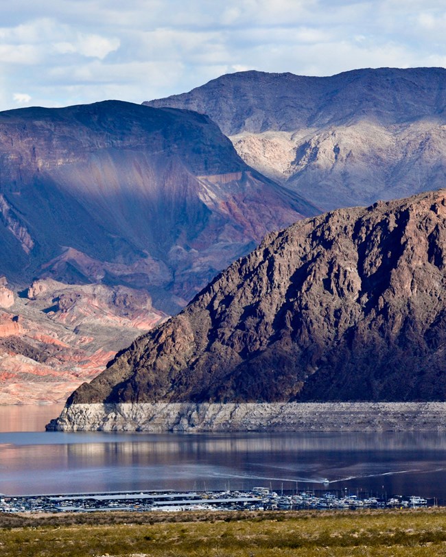
Boulder Basin.
Introduction
Lake Mead National Recreation Area (LAKE) is the first and largest national recreation area in America. It is located in Clark County, Nevada and Mohave County, Arizona. LAKE is situated along the boundary between the Colorado Plateau and Basin and Range provinces, marked by the Grand Wash Cliffs which cross the easternmost part of the Lake Mead segment (Bonde et al. 2018). Lake Mead, formed by Hoover Dam, and Lake Mohave, by Davis Dam, represent two important reservoirs on the Colorado River and provide ~751 km2 (290 mi2 ) of water on which to boat, fish, swim, ski, and sail. The recreation area began as Boulder Dam Recreation Area on October 13, 1936 and received its current name in 1947. It was managed jointly by the NPS and the Bureau of Reclamation until it was placed under the sole jurisdiction of the NPS on October 8, 1964. LAKE encompasses 605,331 hectares (1,495,806 acres) of mountains, canyons, valleys, and two lakes. The recreation area protects nine wilderness areas and 1,347 recorded archaeological sites (Anderson 2017).
Geologic Setting
The geologic history of Lake Mead National Recreation Area is expansive and records rocks ranging in age from the Proterozoic to the Pleistocene. The oldest bedrock in LAKE includes Paleoproterozoic schist and gneiss (between 2.5 to 1.6 Ga) and late Paleoproterozoic–Mesoproterozoic intrusive igneous bodies (1.7 to about 1.4 Ga) (Beard et al. 2007; Bonde et al. 2018). Few gaps in the geologic record can be found since the Cambrian (541 Ma), affording LAKE a long and impressive record that includes Paleozoic–lower Mesozoic sedimentary units, Neogene–Quaternary sedimentary units, and Neogene igneous rocks (Bonde et al. 2018). The Hamblin–Cleopatra Volcano and many of the black volcanic flow-capped mesas, such as Fortification Hill and Callville Mesa, were formed during Neogene-age volcanic episodes.
Regional Geology
Lake Mead National Recreation Area spans two Physiographic Provinces, the Basin and Range and the Colorado Plateau. Most of the park, including Lake Mead and Lake Mohave, lies in the Basin and Range. The detached Arizona portion is on the Colorado Plateau and has the characteristics of the Grand Canyon. In the north part of the Nevada portion, are the Black Mountain and the Muddy Mountains. Muddy Peak, outside the park boundary is at 5,432 feet. The elevation of the water level in Lake Mead varies, but the average from 1939 to 2003 has been 1,176 feet. In 2003, the average was 1,143 feet. To the south, the Colorado River and Lake Mohave are east of the Eldorado and Newberry Mountains. Spirit Mountain in the Newberry Mountains is at 5,639 feet and the elevation of Lake Mohave is below the 800-foot contour. North of the Grand Canyon, Andrus Point is at 5,491 feet and north of Andrus Point the elevation is over 5600 feet.
Geologic Resources Inventory
The Geologic Resources Inventory produces digital geologic maps and reports for more than 270 natural resource parks. The products listed below are currently available for this park, check back often for updates as many maps, reports, and posters are still in progress.
Scoping summaries are records of scoping meetings where NPS staff and local geologists determined the park’s geologic mapping plan and what content should be included in the report.
- Digital geologic maps include files for viewing in GIS software, a guide to using the data, and a document with ancillary map information. Newer products also include data viewable in Google Earth and online map services.
- Reports use the maps to discuss the park’s setting and significance, notable geologic features and processes, geologic resource management issues, and geologic history.
- Posters are a static view of the GIS data in PDF format. Newer posters include aerial imagery or shaded relief and other park information. They are also included with the reports.
- Projects list basic information about the program and all products available for a park.
Source: NPS DataStore Saved Search 2999. To search for additional information, visit the NPS DataStore.
Soil Resources inventory
A NPS Soil Resources Inventory project has been started for Lake Mead National Recreation Area and can be found on the NPS Data Store.
Source: NPS DataStore Saved Search 3046. To search for additional information, visit the NPS DataStore.

Redstone outcrops near Northshore Road.
Related Links
Lake Mead—Geologic History: Ancient Seas
Lake Mead—Abandoned Mineral Lands
Lake Mead National Recreation Area
Narrow By Location
Narrow By Office
Show
10
40
Sort by
Relevance
Recently Updated
Date Released
Title
Loading results...
Tags:
geodiversity
,
geologic
,
[geologic forces](/media/article-search.htm?q=geologic forces)
,
[geologic resources](/media/article-search.htm?q=geologic resources)
,
[geologic feature](/media/article-search.htm?q=geologic feature)
,
[geologic time](/media/article-search.htm?q=geologic time)
,
[geologic layers](/media/article-search.htm?q=geologic layers)
,
[geologic history](/media/article-search.htm?q=geologic history)
,
[geologic formations](/media/article-search.htm?q=geologic formations)
,
geology
,
geological
,
[geological maps](/media/article-search.htm?q=geological maps)
,
geologist
,
[geology talk](/media/article-search.htm?q=geology talk)
,
[geology hike](/media/article-search.htm?q=geology hike)
,
[geology science and learning](/media/article-search.htm?q=geology science and learning)
,
geologists
,
[geology close up](/media/article-search.htm?q=geology close up)
,
[geologic resources inventory](/media/article-search.htm?q=geologic resources inventory)
,
geoheritage
,
geohazards
,
geomorphology
,
[geoscientists in parks](/media/article-search.htm?q=Geoscientists in Parks)
,
geoscientists-in-the-parks
,
[geological survey](/media/article-search.htm?q=Geological Survey)
,
geothermal
,
[geothermal activity](/media/article-search.htm?q=geothermal activity)
,
geotour
,
geotourism
,
[geothermal processes & features](/media/article-search.htm?q=geothermal processes & features)
,
fossils
,
paleontology
,
caves
,
karst
,
glaciers
,
[geoheritage sites](/media/article-search.htm?q=geoheritage sites)
,
earthquakes
,
landslides
,
mining
National Park Service Geodiversity Atlas
The servicewide Geodiversity Atlas provides information on geoheritage and geodiversity resources and values within the National Park System. This information supports science-based geoconservation and interpretation in the NPS, as well as STEM education in schools, museums, and field camps. The NPS Geologic Resources Division and many parks work with National and International geoconservation communities to ensure that NPS abiotic resources are managed using the highest standards and best practices available.
Where this belongs
- Lake Mead National Recreation Area
Where this page came from
This page was imported from National Park Service. Produced by the U.S. National Park Service and, as a work of the United States government, in the public domain.
Nobody has written it yet — it is the source material at a new address, which is why search engines are asked to skip it and why no one earns from it. It is up for grabs: take it on, and it is yours to rewrite and to earn from.
このページを含むコレクションLake Mead National Recreation Area
ライセンス: CC0 1.0(パブリックドメイン) · 出典 www.nps.gov
1
0
0
0

コメント
次に読む


