
Geodiversity is the full variety of a park's natural geologic and soil resources and processes — rocks, minerals, sediments, fossils, landforms and the processes that shape them. The NPS Geodiversity Atlas, a product of the Geologic Resources Inventory, supports education, geoconservation, and management of a park's living and non-living parts together. This is its page for Chiricahua National Monument, Arizona.

The Geologic Resources Inventory report for the park.
A volcanic past
Much of the Precambrian, Paleozoic and Mesozoic record is missing here, but the rocks that are exposed tell a dramatic Cenozoic story of volcanic eruptions.
- Three great eruptions from the Turkey Creek caldera, beginning about 26.9 million years ago, blasted more than 400 km³ (100 mi³) of magma from an underground chamber and buried at least 3,100 km² (1,200 mi²) in pyroclastic debris.
- The eruption that laid down the Rhyolite Canyon Tuff threw out more than a thousand times as much material as Mount St. Helens in May 1980.
- As the magma chamber exploded and collapsed, it left the Turkey Creek caldera, a depression 19 km (12 mi) across and 1,500 m (5,000 ft) deep.
- Hot glass shards fused into welded tuff — the Rhyolite Canyon Tuff, at least 490 m (1,600 ft) thick. The monument also preserves volcanic ash, glowing gas cloud deposits, steam vents, lava flows and high-velocity surge deposits.
From tuff to hoodoos
As the tuff cooled, vertical joints opened in the hard, erosion-resistant rock and channeled water. Endless freezing and thawing widened the joints and pried loose pieces of rock, and over time chemical and physical weathering together carved the pinnacles, spires and columns — the hoodoos — for which the monument is known. It was established in 1924 to protect them, and its balanced rocks that seem to defy gravity; it also protects geologically important remnants of the caldera.
| Kind | Features |
|---|---|
| Weathering and erosion | slot canyons, slumps, a natural bridge, solution pans, rock varnish, tafoni, spherulites, inverted topography |
| The monument's signature | pinnacles, spires, balanced rocks, columns |
| Volcanic (mostly the caldera) | the caldera, welded tuff, fiamme, fumarole pipes, moat deposits, surge deposits, igneous dikes |
Fossils
Brachiopods, echinoid spines and gastropods are abundant in the Concha Limestone, Colina Limestone, Epitaph Dolomite, Earp Formation and Horquilla Limestone.
- Colina Limestone: bryozoans, brachiopods, pelecypods, gastropods, echinoids.
- Concha Limestone: fusulinid foraminifera, sponges, corals, bryozoans, brachiopods, gastropods, scaphopods, pelecypods, ammonoid cephalopods, echinoids and crinoids.
All NPS fossils are protected by the Paleontological Resources Preservation Act of 2009.

A historic inscription dated 1886, carved in stone at the monument. Image from the Park Service's page.
Region, maps and reports
The monument lies in the Basin and Range province. The Geologic Resources Inventory makes scoping summaries, digital geologic maps, reports and posters for more than 270 natural resource parks; this park's are in the NPS DataStore, including its Geologic Resources Inventory report. A Soil Resources Inventory has not yet been completed; general information is in the DataStore. More: the park's geologic formations and the Arizona Geological Survey.
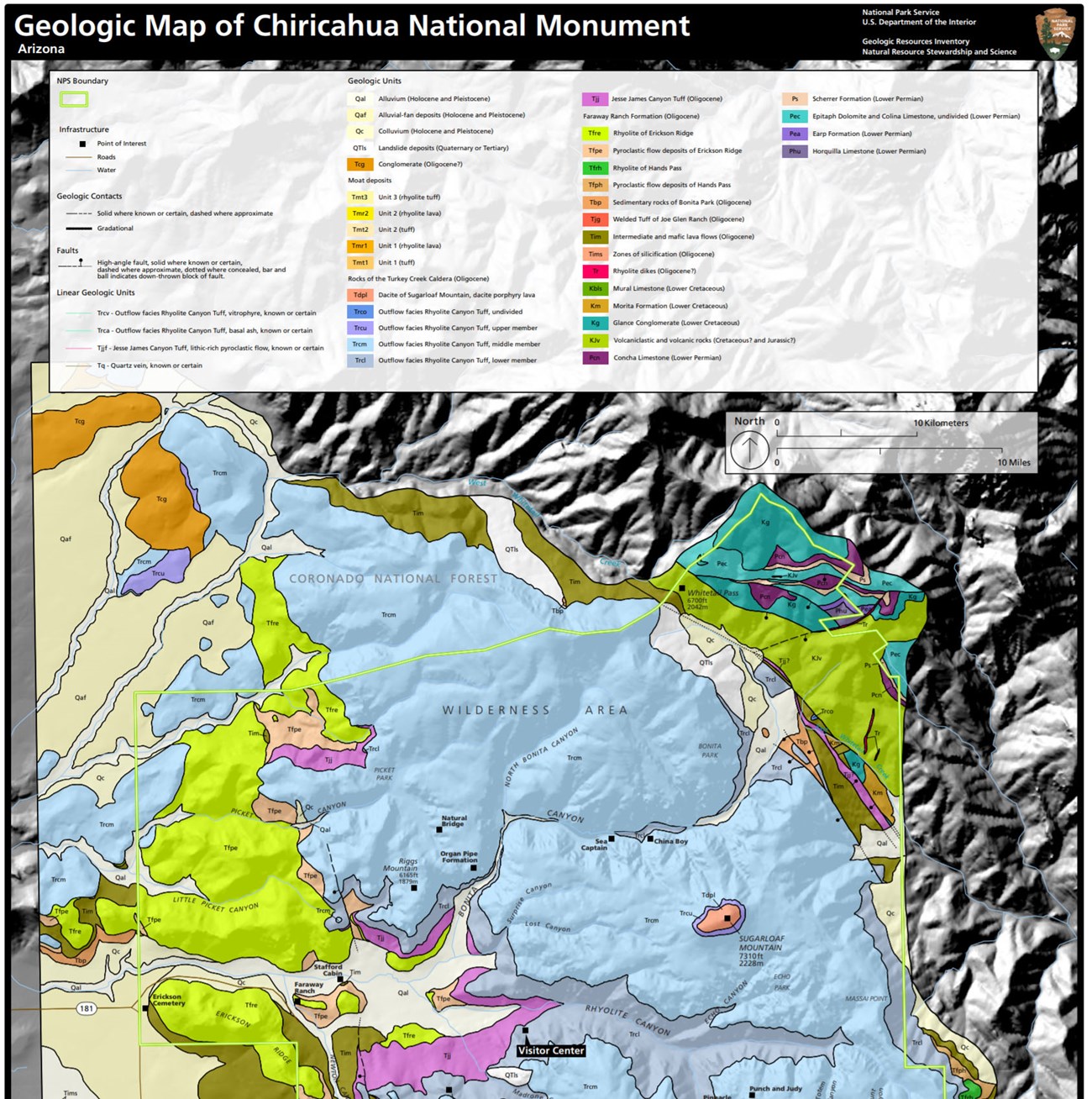
The monument's geologic map from the Geologic Resources Inventory.
Sources
Based on "NPS Geodiversity Atlas—Chiricahua National Monument, Arizona," National Park Service; a work of the United States government in the public domain.
このページを含むマガジンChiricahua National Monument
ライセンス: CC0 1.0(パブリックドメイン) · 出典 www.nps.gov
1
0
0
0

コメント


