The Tropical Rainfall Measuring Mission (TRMM) satellite looked into the heart of Hurricane Ivan at 05:09 UTC (1:09 AM EDT) on September 15, 2004. This satellite overflight happened approximately one day before Ivan made landfall in Alabama and before Ivan was within range of the National Weather Serviceâs weather radars. The TRMM Precipitation Radar captured this view of the heavy rain in the eyewall that surrounds the quiet eye of the storm. Unlike the eye, the eyewall is the portion of the hurricane with the most violent surface winds and with strong convective rainfall. Scientists believe that particularly tall regions of rain in the eyewall are associated with increases in the intensity of the surface windsâand wind intensity is particularly difficult to forecast.
In the top view of the storm, there is a heavy arc of rain between the Points A and B. In the side view of the storm, it becomes clear that the tallest region of rainfall is near Point A. In both cases, the blue three dimensional volume contains all regions where there is light rainfall (at least 2 mm/h) as measured by the TRMM Precipitation Radar. The red volume contains all regions of heavy rainfall (at least 25 mm/h). In the side view, the rain region near Point A is approximately 12 km (7.5 miles) high. The vertical dimension has been stretched to make it easier to see the structure of the storm.
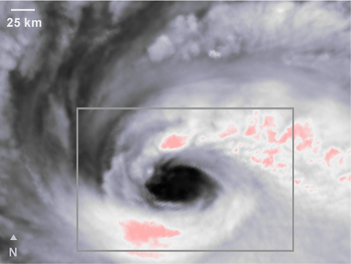
The height of the cloud top is not necessarily the same as the height of the region of rain inside the clouds. In fact, the TRMM instruments show a dramatic difference between cloud height and rain height around the eye of Hurricane Ivan. While the TRMM Precipitation Radar saw the heaviest rain to the northeast of the central eye, TRMM infrared data show a pair of very tall cloud tops to the north and south of the eye. In the infrared image, dark gray indicates warm clouds that are therefore low and white and pink indicate cold clouds that are therefore higher up. The gray rectangle locates the position of the Precipitation Radar image shown above.
Where this page came from
This page was imported from NASA Science. Published by NASA and, as a work of the United States government, in the public domain; pictures credited to others are left out.
Nobody has written it yet — it is the source material at a new address, which is why search engines are asked to skip it and why no one earns from it. It is up for grabs: take it on, and it is yours to rewrite and to earn from.
이용 허락: CC0 1.0 (퍼블릭 도메인) · 출처 www.nesdis.noaa.gov
1
0
0
0

코멘트