
The U.S. Geological Survey (USGS) recently estimated total oil shale resources in the Piceance Basin of the Eocene Green River Formation in western Colorado to be approximately 1.525 trillion barrels of oil in-place, regardless of grade (Johnson and others, 2010). In an attempt to further refine this estimate, we determined that about 920 billion barrels or 60 percent of the in-place total can be generated from oil shale yielding at least 15 gallons of oil per ton of rock (GPT), and about 352 billion barrels or 23 percent of the total is associated with oil shale yielding at least 25 GPT (Mercier and others, 2010).
The Green River Formation, deposited in Eocene Lake Uinta, is subdivided into an early illitic phase, the Garden Gulch Member, which predates saline-mineral deposition in the lake (fig. 1, R-0 through L-1 oil shale zones), and a later carbonate and saline-mineral phase, the Parachute Creek Member, during which the saline minerals nahcolite and halite were deposited in offshore areas of the lake (fig. 1, R-2 zone through bed 44 interval). These two intervals are separated by a brief transitional section in the lower R-2 zone (fig. 1 and fig. 3) where illite content is greatly reduced, dolomite appears as a significant component, and saline minerals are not yet present. Saline minerals have been extensively leached by groundwater from shallower parts of the saline interval by relatively recent groundwater movement, producing vuggy and brecciated oil shale around the intact saline areas (figs. 2 and 3). Here, in-place oil shale resources are estimated for: (1) the Garden Gulch Member, (2) the Parachute Creek Member prior to the appearance of saline minerals, (3) the Parachute Creek Member where saline minerals are intact, (4) the Parachute Creek Member where saline minerals have been leached, and (5) the marginal oil shales from around the outer margins of the basin where saline minerals were never present. In addition, the in-place resource in the Mahogany zone and bed 44 within the leached interval of the Parachute Creek Member are estimated separately from the other leached oil shale resources due to their geological and potential economic importance.

Figure 1. Chart showing oil yield in gallons per ton and the “rich” and “lean” oil shale zones in Green River Formation, Piceance Basin, assessed in this study (Donnell and Blair, 1970; Cashion and Donnell, 1972). On the right side, the major stratigraphic-mineralogical intervals are highlighted.

Figure 2. Distribution of in-place nahcolite resources and related features based on core analysis in the R-4 oil shale zone, Parachute Creek Member of the Green River Formation, Piceance Basin, Colorado.
The presence of nahcolite and halite in the saline-mineral interval and the existence of vugs and collapse breccias in the leached interval are of concern because of their influence on in situ oil shale extraction techniques that may be applied to the commercial development of Green River oil shale in the Piceance Basin. Nahcolite is distributed widely in the basin center (see figs. 2 and 3), and it is a leasable mineral as defined by the Bureau of Land Management. Therefore, nahcolite cannot be destroyed during the development of oil shale resources. Several companies that currently hold research, development, and demonstration (RD&D) leases on Federal lands are studying approaches to develop both nahcolite and oil shale resources using combinations of solution mining and in situ retorting technologies. A potential issue with this combination of processes arises when oil shale heating precedes nahcolite recovery. Carbon dioxide (CO2) gas is released when nahcolite breaks down into natrite (a sodium carbonate mineral) at between 100 and 200 °C (212–392 °F) depending on depth (Boak, 2011), which is significantly below oil shale retort temperatures (>350 °C or 660 °F). The decomposition products retain the original mineral value of the nahcolite and can still be recovered by solution mining following retorting. The increased CO2 released during oil shale production, however, along with the additional energy the nahcolite decomposition reaction consumes, may make oil shale retorting prior to nahcolite extraction less viable due to potentially higher energy costs and concerns over CO2 emissions. In some instances, reclamation requirements and water-use restrictions for dual oil shale-nahcolite recovery operations may require that postretorting water flushing and solution mining of the sodium minerals be conducted simultaneously, despite CO2 concerns.
The significant porosity and groundwater movement within the leached interval also complicates mining or implementation of the down-hole heater systems currently being developed for in situ oil shale retorting. The leached interval contains the upper and lower Piceance Basin aquifer systems (Weeks and others, 1974), which are protected groundwater resources separated by the Mahogany zone. Therefore, in situ development of the rich oil shales in the Mahogany and other oil
shale zones within the leached interval (fig. 1, principally R-5 and R-6 zones) will require preservation of water quality in these aquifers. It is also undesirable to use down-hole heaters when significant amounts of water are present because additional energy is required to achieve retorting temperatures. To address this issue, freeze-wall technology has been tested on a pilot-scale for use in isolating in situ retorts during oil shale processing in the leached interval. This technique allows operators to pump groundwater out of the retort site, isolating it from groundwater flow during oil shale heating and oil production. This approach is energy-intensive and operationally complicated, but it is also robust and fully reversible, unlike other methods of isolating in situ retorts such as grouting or hydraulic bypass.

Table 1. Oil shale resources in stratigraphic-mineralogical intervals in the Green River Formation, Piceance Basin, Colorado.
In situ development of the Garden Gulch Member is also being studied by RD&D lease holders. Because the illitic interval does not contain nahcolite or protected groundwater resources and is effectively sealed by the overlying saline-mineral interval, retorting can be conducted without isolating the site and without additional treatment to solution-mine saline minerals or to remediate spent shale following heating (Burnham and others, 2010). Although this simplifies the development approach, the greater depth of this interval, typically between 2,000 and 2,200 feet below the surface in the basin center, may complicate heating operations.

Table 1 lists the amount of in-place oil in the defined intervals, including total oil in oil shale grades ≥ 15 GPT and ≥ 25 GPT. Of the total in-place oil (1.525 trillion barrels), 203.2 billion barrels (13.3 percent) are associated with the saline-mineral interval and 703.6 billion barrels (46.1 percent) are present in the leached interval (including the Mahogany zone and bed 44). The illitic shales contain 302.2 billion barrels (19.8 percent). Figure 4 shows a histogram summarizing the total distribution of the Piceance Basin oil shale resource according to grade (Birdwell and others, 2013) and how the resource is distributed within the major stratigraphic-mineralogical intervals. The non-saline lower R-2 zone, Mahogany zone, and bed 44 intervals (fig. 1) are plotted separately from the leached interval on the distribution plot.
Each of the major oil shale intervals within the Piceance Basin contain resource with high development potential but also has unique challenges related to resource recovery. The analysis presented here highlights the association between saline minerals and high-grade oil shale in the Piceance Basin. The majority of the high-grade oil shale resource in the Piceance Basin, 128.6 billion barrels (36.6 percent of the total ≥ 25 GPT), and most of the richest oil shales in the basin (≥ 30 GPT) (fig. 4) are concentrated in the saline-mineral interval. This has important implications, both for understanding the geological setting of Eocene Lake Uinta and facilitating the development of Piceance Basin oil shale resources.
Methods
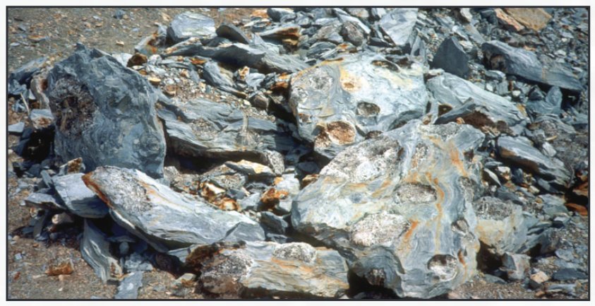
Nahcolite nodules or aggregates from the R-5 oil shale zone (see fig. 1) in the Green River Formation, Piceance Basin. Photograph taken at the Superior quarry in Rio Blanco County, Colorado.
Oil shale grade is determined by the Fischer assay method, which is used to measure oil yield under a particular set of pyrolysis conditions (American Society for Testing and Materials, 1980). Data summarizing Fischer assay analyses conducted on Piceance Basin oil shale samples are available as part of the most recent USGS assessment report (U.S. Geological Survey Oil Shale Assessment Team, 2010).
The oil shale interval in the Piceance Basin is subdivided into 17 stratigraphically defined “rich” and “lean” zones, 13 of which contain or once contained saline minerals (fig. 1) (Donnell and Blair, 1970; Cashion and Donnell, 1972). The extent of the saline-mineral area for each of the 13 zones was modified from Brownfield and others (2010), and the extent of saline-mineral leaching was determined using core descriptions and x-ray diffraction analysis (figs. 2 and 3). After the extents of the saline mineral and leached intervals were defined, oil shale resource data (U.S. Geological Survey Oil Shale Assessment Team, 2010) were incorporated using geographic information systems (GIS) technology to determine how much in-place oil was present in the 17 (4 illitic, 13 saline mineral and leached) oil shale zones (fig. 1) on a per-acre basis, then separated and summed for the intervals of interest. The non-saline portion of the R-2 zone was considered
References Cited
separately, while the upper portion of R-2 that contains nahcolite was included with the saline-mineral interval. A zonal statistics function was used to develop the histograms (fig. 4) relating oil shale grade (GPT)
to total oil yield (barrels of oil) for each interval and selected zones.
The resolution of the analysis is constrained by the data density and stratigraphic resolution.
For additional information contact: Director, Central Energy Resources Science Center
Box 25046, MS 939 Denver Federal Center Denver, CO 80225-0046 http://energy.usgs.gov
Where this page came from
This page was imported from U.S. Geological Survey. Published by the U.S. Geological Survey and, as a work of the United States government, in the public domain.
Nobody has written it yet — it is the source material at a new address, which is why search engines are asked to skip it and why no one earns from it. It is up for grabs: take it on, and it is yours to rewrite and to earn from.
이용 허락: CC0 1.0 (퍼블릭 도메인) · 출처 pubs.usgs.gov
1
0
0
0

코멘트


