

The Fremont River in Capitol Reef National Park. NPS.
In dry country, the riparian areas along streams and rivers are oases. They are biologically rich and do important work: streamside plants filter excess nutrients and sediment from runoff and shallow groundwater, and shade the water, keeping light and temperature right for aquatic plants, fish and other animals. Tied to both water and land, they can be sensitive indicators of change across a landscape — and dams, diversions, channel works, invasive species, grazing, logging, land clearing, groundwater pumping and trails can all disrupt them downstream.
The National Park Service's Northern Colorado Plateau Network (NCPN) monitors wadeable streams for hydrology (including how often they flood), channel shape and makeup (geomorphology) and vegetation, which together describe normal conditions and warn managers of trouble. At Capitol Reef it monitors four reaches of the Fremont River. This summarizes 2009–2021.
| Reach | Location | Monitored |
|---|---|---|
| F-01 | About 2.5 km upstream of a knickpoint — a sharp change in slope with a waterfall — that formed after State Highway 24 was built in 1964 | geomorphology, vegetation, hydrology |
| F-07 | A large oxbow cut off by the highway's construction | geomorphology, vegetation |
| F-04 | About 1.5 km downstream of the knickpoint | geomorphology, vegetation |
| F-14 | About 4.8 km downstream of the knickpoint | geomorphology, vegetation |
Key findings
- With the potential for less water coming in and more lost to evaporation and plants, the Fremont River risks progressively lower flows; peak flows showed the greatest declines.
- Flooding was rare at the monitored reach, limiting new cottonwoods — but groundwater stayed shallow enough to sustain mature trees.
- Channels were stable or building up at every reach.
- Three reaches had typical Fremont cottonwood woodland; the abandoned oxbow has become upland.
Water
The river flowed year-round, with a strong seasonal pattern tied to the irrigation season (April 1–October 31). At F-01, daily mean flow ranged from 16.5 to 118 cubic feet per second (cfs), with a median of 60 cfs. On 25 days it fell below 23.5 cfs — the combined water right of downstream users — all during irrigation season, when both irrigation withdrawals and natural losses from heat and plant use lower the flow. Outside irrigation season, flow at the USGS Bicknell gage, about 34 km upstream, predicts F-01 fairly well, and flow there declined from water year 2001 to 2021.

Daily mean flow at F-01, water years 2015–2021; red points fell below the 23.5 cfs downstream water right. NPS.
Floods that spill over the banks were infrequent at F-01, usually brief pulses from intense late-summer and fall monsoon storms. New cottonwoods generally need spring floods that recede slowly, and these lacked the right timing and length. Still, groundwater averaged about two meters below the surface — well within the less than 4 meters mature cottonwoods need. Only legacy trees remain on the higher floodplain, though they resprout after disturbances such as beaver browsing. Lower flows over time are projected for surface waters throughout the Southwest because of human-caused climate change, and the Fremont is at risk too.
The channel
At F-01 and F-14, up to one meter of sediment built up on the floodplain, mostly between 2009 and 2014. Erosion was only local, and surveys of each channel's deepest line (the thalweg) showed channels stable or rising. The biggest changes matched peak flows. The abandoned oxbow, F-07, which carries no flow, barely changed.
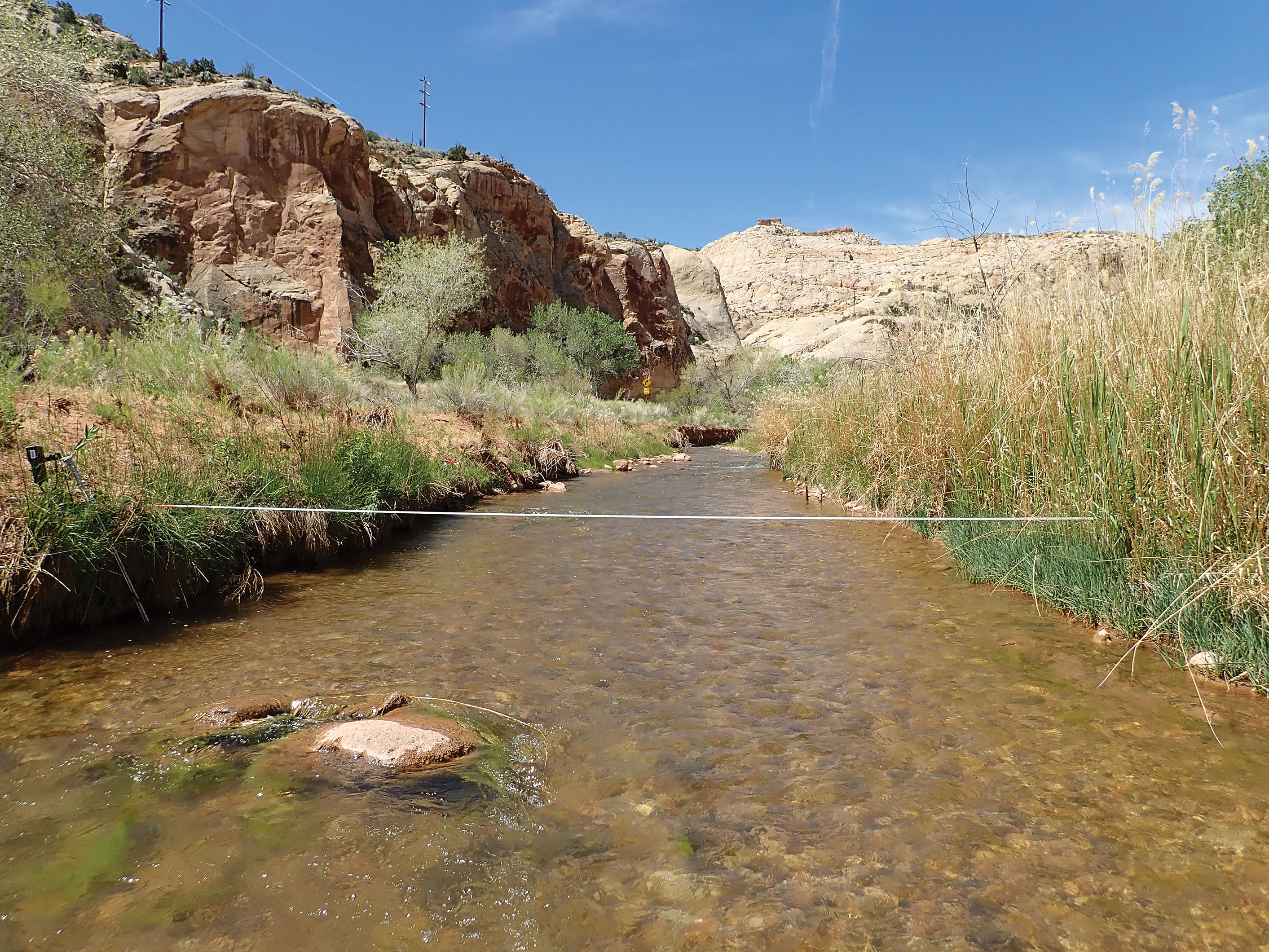
Transect 1 at reach F-01, looking upstream, May 2020. NPS.
Vegetation
F-01, F-04 and F-14 are typical mature riparian systems of the arid Southwest: a Fremont cottonwood canopy over mixed shrubs, with dense cover — near or above 40% in some years — at F-01 and F-14. Photos from the early 1900s show cottonwoods and willows almost absent from the river corridor; now they are abundant.

The Fremont River in 1950. NPS/Charles Kelley.

The same stretch in 2022: the wide, braided channel has narrowed and cut down, and once-bare banks are held by coyote willow and common reed. NPS/Rebecca Weissinger.
- Native plants dominated these three reaches, with wetland-dependent species and cottonwoods of mixed ages, but few young cottonwoods grew into larger trees, and relying on legacy trees on the higher floodplain may leave the system less resilient. Cottonwood densities were at the low end of the range for mature stands (50–400+ trees per hectare). F-14 had more plants that can grow in wetlands or uplands; at F-01 and F-14, wetland-only species fell to their lowest in 2021.
- Cottonwoods structure riparian communities across the Colorado Plateau, and new stands need big floods that lay down fresh sediment followed by steady soil moisture. Park staff wrapped young trees in chicken wire against beavers, but some fast-growing trees are now being girdled by it.
- The oxbow (F-07) is now dominated by upland forbs and shrubs such as rabbitbrush, four-wing saltbush and non-native Russian thistle. It has lost all its wetland-dependent species and almost all its cottonwoods, and has no trees or ferns on its transects.
- Exotic plants covered under 10% at F-01, F-04 and F-14 every year. Control of Russian olive visibly reduced its saplings, and tamarisk stayed low thanks to earlier control and tamarisk beetles. At F-07, exotic cover ran from 9% to 25%, and was most of the plant cover in 2009–2011; a flush of cheatgrass in 2011 raised annual grass cover from under 1% to 10%, and it stayed high a decade later. Nine species on the park's invasive priority list were found: tree-of-heaven, asparagus, blue mustard, bull thistle, Russian olive, quackgrass, African mustard, alfalfa and tamarisk.

A mature cottonwood along the Fremont River. NPS.
Recommendations
- Advocate for spring snowmelt flows of 94 cfs or more at F-01 — for example, by opposing new upstream reservoirs and diversions and keeping the state irrigation season starting April 1.
- For more accurate flow records, consider a gage in the park or reopening the Caineville gage below it.
- Protect young cottonwoods from beavers, and remove chicken wire that is restricting or girdling grown trees.
- Keep controlling Russian olive and tamarisk.
- Advocate restoring the abandoned oxbow, where riparian function has been lost.

Reach F-07, the abandoned oxbow, in 2012. NPS.
Sources
Rewritten from the National Park Service article "Riparian Health on the Fremont River, Capitol Reef National Park, 2009–2021," summarizing C. Livensperger, Natural Resource Report NPS/NCPN/NRR—2023/2584 (public domain), in hubnx's own words.
이 페이지가 속한 매거진Capitol Reef National Park
이용 허락: CC0 1.0 (퍼블릭 도메인) · 출처 www.nps.gov
1
0
0
0

코멘트


