
National Assessment of Oil and Gas Fact Sheet
Using a geology-based assessment methodology, the U.S. Geological Survey estimated a mean of 41 trillion cubic feet of undiscovered natural gas and a mean of 1.3 billion barrels of undiscovered oil in the Permian Basin Province.
Introduction
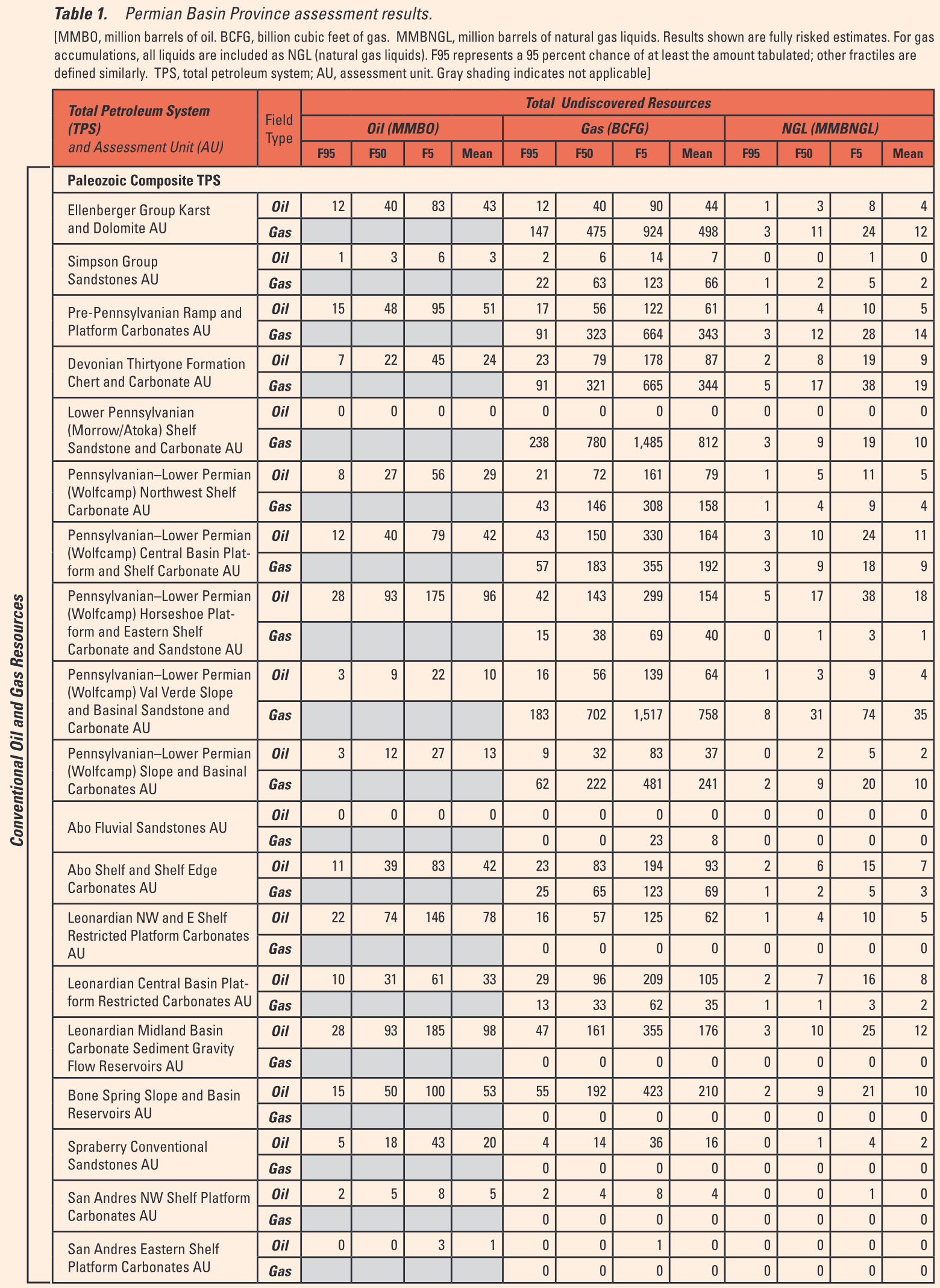
The U.S. Geological Survey (USGS) recently assessed the undiscovered oil and gas potential of the Permian Basin Province of west Texas and southeast New Mexico (figs. 1, 2). The assessment was geology based and used the total petroleum system (TPS) concept. The geologic elements of a total petroleum system are petroleum source rocks (quality, source rock maturation, generation, and migration), reservoir rocks (sequence stratigraphy, petrophysical properties), and traps (trap formation and timing). Using this geologic framework, the USGS defined a Paleozoic Composite Total Petroleum System and 31 assessment units (AU) within the system, and it quantitatively estimated the undiscovered oil and gas resources within 30 of the assessment units (table 1). This study assessed potential for technically recoverable resources in new field discoveries only; field growth (or reserve growth) of conventional oil and gas fields was not included.
Each of the 26 conventional oil and gas assessment units in this study is geologically comparable to one or more oil and gas plays that were defined in the Permian Basin Province by the Bureau of Economic Geology, Texas, and the New Mexico Bureau of Geology and Mineral Resources (Broadhead, 1993; Dutton and others, 2005). Some oil and gas plays were combined to form a single assessment unit.
For the first time, the USGS defined continuous (unconventional) assessment units in the Permian Basin Province. These units were the (1) Spraberry Continuous Oil AU; (2) Woodford–Barnett Continuous Gas AU; (3) Delaware– Pecos Basins Woodford Continuous Shale Gas AU; (4) Delaware–Pecos Basins Barnett Continuous Gas Shale AU; and (5) Delaware Basin Wolfcamp Shale AU.

Figure 1. Permian Basin Province in west Texas and southeastern New Mexico. The Permian Basin Province contains the Midland Basin, Delaware Basin, Pecos Basin, Central Basin Platform, Val Verde Basin, Ozona Arch, and the Northwestern, Northern, and Eastern Shelves.

Figure 2. Photograph of the Guadalupe Mountains in west Texas illustrating the massive El Capitan carbonate fore-reef facies and the underlying slope-forming Delaware Mountain Group sandstones and mudstones.
Resource Summary
The USGS assessed undiscovered conventional oil and gas resources and continuous (unconventional) oil and gas resources in 30 assessment units (table 1). For conventional resources, the estimated means were 747 million barrels of oil (MMBO), 5.2 trillion cubic feet of gas (TCFG), and 236 million barrels of natural gas liquids (MMBNGL) in 26 assessment units.
For continuous gas resources, the USGS estimated a total mean resource of 34.8 TCFG in three assessment units, which comprises a mean of 2.8 TCFG in the Woodford–Barnett Continuous Gas AU of the Midland Basin, a mean of 15 TCFG in the Delaware– Pecos Basins Woodford Continuous Shale Gas AU, and a mean of 17 TCFG in the Delaware–Pecos Basins Barnett Continuous Gas Shale AU in the Delaware Basin. The Delaware Basin Wolfcamp Shale AU was not assessed. For continuous oil resources the estimated mean was 510 MMBO in the Spraberry Continuous Oil AU in the Midland Basin.
The assessment indicates that the majority of undiscovered natural gas in the Permian Basin Province is estimated to be in three continuous assessment units of the Delaware and Midland Basins. Of the total mean of 41 TCFG in the province, about 35 TCFG is estimated to be in these three assessment units. Given that few wells have produced from these assessment units, there is significant geologic uncertainty in these estimates, which is reflected in the range of estimates for natural gas (table 1).
For Further Information
Supporting geologic studies of the composite total petroleum system and assessment units and the methodology used in the Permian Basin Province assessment are in progress. Assessment results are available at the USGS Central Energy Team website, http://energy.cr.usgs.gov/oilgas/noga.
References
Broadhead, R.F., 1993, Permian Basin Permian [PB] plays—Overview, in Robertson, J.M., and Broadhead, R.F., eds., Atlas of major Rocky Mountain gas reservoirs: New Mexico Bureau of Mines and Mineral Resources, p. 138–153.
Dutton, S.P., Kim, E.M., Broadhead, R.F., Raatz, W.D., Breton, C.L., Ruppel, S.C., and Kerans, C., 2005, Play analysis and leadingedge oil-reservoir development methods in the Permian Basin—Increased recovery through advanced technologies: American Association of Petroleum Geologists Bulletin, v. 89, no. 5, p. 553–576.
Permian Basin Province Assessment Team
Christopher J. Schenk, Richard M. Pollastro, Troy A. Cook, Mark J. Pawlewicz, Timothy R. Klett, Ronald R. Charpentier, and Harry E. Cook.
Where this page came from
This page was imported from U.S. Geological Survey. Published by the U.S. Geological Survey and, as a work of the United States government, in the public domain.
Nobody has written it yet — it is the source material at a new address, which is why search engines are asked to skip it and why no one earns from it. It is up for grabs: take it on, and it is yours to rewrite and to earn from.
Licence: CC0 1.0 (public domain) · Adapted from pubs.usgs.gov
1
0
0
0

Comments


