
The U.S. Geological Survey (USGS) assessed the potential for undiscovered, technically recoverable conventional oil and gas resources off East Africa and around the Seychelles, as part of its ongoing assessment of priority petroleum provinces around the world. The assessment is dated 2022.
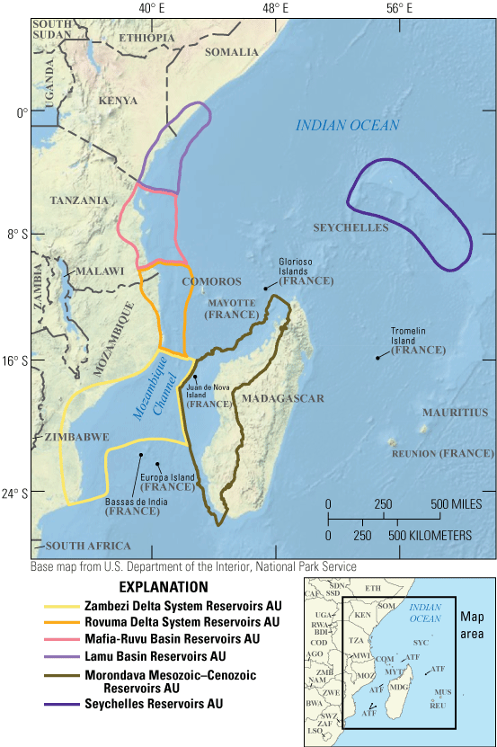
The six conventional assessment units of offshore East Africa and the Seychelles. U.S. Geological Survey.
How the margin formed
The East African continental margin took shape as east Gondwana (Antarctica, Australia, New Zealand, Madagascar, India and the Seychelles) rifted away from west Gondwana (Africa and South America), beginning in the late Paleozoic, and as east Gondwana later broke into microcontinents during the Mesozoic. Mantle plumes, or hot spots, influenced the rifting, which came in four phases:
- Latest Carboniferous to Triassic: the regionally extensive, northeast-trending Karoo rifts, some of which may hold Triassic organic-rich lake shales.
- Early to Middle Jurassic: rifting oblique to the Karoo rifts. Its basins may contain organic-rich shales, overlain by Upper Jurassic organic-rich shales laid down as the crust cooled and subsided; Jurassic shales may be the margin's most important petroleum source rocks. This phase preceded final breakup, the start of seafloor spreading in the Middle Jurassic, and the formation of ocean crust off Mozambique, as Madagascar separated along the Davies and Mozambique fracture zones. Madagascar stopped moving in the Early Cretaceous (Aptian) and became part of the margin as spreading shifted east of it.
- Late Jurassic to Early Cretaceous: rifting centered on the South African margin, which also formed the Anza Basin in the north of the assessment area.
- Paleogene (Oligocene) onward: the East African rift system.
Sills, lava flows and volcanic layers seen in seismic data occur along the whole margin. From the Cretaceous to the Neogene, huge river catchments built deltas that grew eastward, the Zambezi, Rovuma, Mafia-Ruvu and Lamu delta systems. Their sediment wedges, 5 to 11 kilometers thick, may have buried Mesozoic source rocks deep enough to generate oil and gas.
Petroleum systems and assessment units
The USGS defined a Mesozoic–Cenozoic Composite Total Petroleum System off East Africa and Madagascar, containing five assessment units: the Zambezi Delta System, Rovuma Delta System, Mafia-Ruvu Basin, Lamu Basin and Morondava Mesozoic–Cenozoic reservoirs. They span large river-delta to deep-water sediment systems. Source rocks there are poorly known because they are deeply buried and little sampled; Triassic source rocks matter in Madagascar's Morondava Basin, and Jurassic ones are generally considered most important along the margin. Reservoirs are typical of deltas: sandstones laid down by rivers, near shore, in slope channels and in basin-floor fans. Recent gas discoveries in the Rovuma unit, where most exploration has happened, are in stacked deep-water sandstones with excellent reservoir properties. Traps range from purely stratigraphic ones in deep-water sands to structural traps, such as those formed by gravity-driven extension and contraction in the Rovuma delta.
Around the Seychelles, a Mesozoic Composite Total Petroleum System contains the Seychelles Reservoirs unit. Possible source rocks include Triassic rift-lake shales and Upper Jurassic to Lower Cretaceous marine shales. Reservoirs range from alluvial and river sandstones to lake-margin and deep-lake sandstones and delta-to-coastal sandstones, and may include Cretaceous carbonate reefs and karst.
The estimates
Across the six units, the USGS estimated mean undiscovered, technically recoverable resources of:
| Resource | Mean | Range (F95–F5) |
|---|---|---|
| Oil | 5,071 million barrels (5.1 billion) | 1,401 to 11,828 million barrels |
| Gas | 79,133 billion cubic feet (79.1 trillion) | 28,606 to 157,242 billion cubic feet |
| Natural gas liquids | 451 million barrels (0.5 billion) | 159 to 906 million barrels |
F95 means a 95% chance of at least that amount; the results are fully risked.
| Assessment unit | Mean oil (million barrels, in oil fields) | Mean gas (billion cubic feet, in gas fields) |
|---|---|---|
| Zambezi Delta System | 995 | 19,700 |
| Rovuma Delta System | 573 | 19,385 |
| Mafia-Ruvu Basin | 662 | 15,821 |
| Lamu Basin | 455 | 2,714 |
| Morondava Mesozoic–Cenozoic | 1,992 | 12,890 |
| Seychelles (probability 0.9) | 394 | 2,368 |
Oil fields also contain associated gas, and gas fields contain natural gas liquids, which are included in the totals above.
Sources
- U.S. Geological Survey, "Assessment of undiscovered conventional oil and gas resources of offshore East Africa and the Seychelles, 2022," Fact Sheet 2024–3010, by the Offshore East Africa and Seychelles Assessment Team (Christopher J. Schenk and others). https://pubs.usgs.gov/publication/fs20243010/full
- Assessment input data: Schenk (2024); USGS Energy Resources Program: https://www.usgs.gov/programs/energy-resources-program
Licence: CC0 1.0 (public domain) · Adapted from pubs.usgs.gov
1
0
0
0

Comments


