
North and South Carolina, 1995–98 POINTS OF CONTACT AND ADDITIONAL INFORMATION By W. Brian Hughes, Thomas A. Abrahamsen, Terry L. Maluk, Eric J. Reuber, and Lance J. Wilhelm

NATIONAL WATER-QUALITY ASSESSMENT PROGRAM
THIS REPORT summarizes major findings about water quality in the Santee River Basin and coastal drainages that emerged from an assessment conducted between 1995 and 1998 by the U.S. Geological Survey (USGS) National Water-Quality Assessment (NAWQA) Program. Water quality is discussed in terms of local and regional issues and compared to conditions found in all 36 NAWQA study areas, called Study Units, assessed to date. Findings are also explained in the context of selected national benchmarks, such as those for drinking-water quality and the protection of aquatic organisms. The NAWQA program was not intended to assess the quality of the Nation’s drinking water, such as by monitoring water from household taps. Rather, the assessments focus on the quality of the resource itself, thereby complementing many ongoing Federal, State, and local drinking-water monitoring programs. The comparisons made in this report to drinking-water standards and guidelines are only in the context of the available untreated resource. Finally, this report includes information about the status of aquatic communities and the condition of in-stream habitats as elements of a complete water-quality assessment.
Many topics covered in this report reflect the concerns of officials of State and Federal agencies, water-resource managers, and members of stakeholder groups who provided advice and input during the Santee River Basin and coastal drainages assessment. Basin residents who wish to know more about water quality in the areas where they live will find this report informative as well.

THE NAWQA PROGRAM seeks to improve scientific and public understanding of water quality in the Nation’s major river basins and ground-water systems. Better understanding facilitates effective resource management, accurate identification of water-quality priorities, and successful development of strategies that protect and restore water quality. Guided by a nationally consistent study design and shaped by ongoing communication with local, State, and Federal agencies, NAWQA assessments support the investigation of local issues and trends while providing a firm foundation for understanding water quality at regional and national scales. The ability to integrate local and national scales of data collection and analysis is a unique feature of the USGS NAWQA Program.
The Santee River Basin and coastal drainages is one of 51 water-quality assessments initiated since 1991, when the U.S. Congress appopriated funds for the USGS to begin the NAWQA Program. As indicated on the map, 36 assessments have been completed, and 15 more assessments will conclude in 2001. Collectively, these assessments cover about one-half of the land area of the United States and include water resources that are available to more than 60 percent of the U.S. population.
IV National Water-Quality Assessment Program
SUMMARY OF MAJOR FINDINGS

The Santee River Basin and coastal drainages (the “Santee Basin”) is an approximately 24,000-square-mile area in North and South Carolina that encompasses the Blue Ridge Mountains, the Piedmont, and the Coastal Plain (Fenneman, 1946). Most of the 3.5 million people in the Santee Basin live in urban areas. Eighty- six percent of the water used in homes and for industry is treated surface water withdrawn from rivers or reservoirs. Ground water is the main water source for rural households.
Stream and River Highlights
Surface water sampled in the Santee River Basin and coastal drainages generally meets existing Federal and State guidelines for drinking-water quality and protection of aquatic life. However, urban and agricultural land uses have affected water quality, as indicated by elevated concentrations of bacteria, pesticides, and nutrients in basins dominated by these land uses.
~ Insufficient data
Summary of Major Findings
Ground-Water Highlights
Ground water in the Santee Basin generally meets existing Federal and State standards for drinking water except with respect to nitrate, which failed to meet the drinking-water standard in almost one-half of the shallow monitoring wells sampled in agricultural areas, and radon, which did not meet proposed standards in about one-half the drinking-water wells sampled basinwide. Pesticides were detected frequently in urban, agricultural, and drinking-water supply wells, but only two samples exceeded drinking-water standards. Many wells contained low concentrations of numerous synthetic chemicals related to industry, household use, and motor vehicles, and a few of these chemicals were at levels above drinking-water standards.

Water Quality in the Santee River Basin and Coastal Drainages
INTRODUCTION TO THE SANTEE RIVER BASIN AND COASTAL DRAINAGES
The Santee River Basin and coastal drainages includes about 24,000 square miles in North and South Carolina. The Santee River has the second largest drainage area in the Eastern United States, and its basin makes up 70 percent of the study area. The basins of the Cooper, Edisto, and numerous smaller rivers make up the remainder of the study area.Throughout this report, the study area, including these smaller river basins, will be collectively referred to as the “Santee Basin.”
Physiography and Water Quality
The rugged mountains of the Blue Ridge physiographic province are sparsely populated. Land-use effects on water quality are minimal because the area is largely undeveloped. Consequently, the Blue Ridge has more pristine water quality and intact stream ecosystems than other parts of the study area.
The rolling hills and abundant water resources of the Piedmont have attracted industrial development and human population growth. Many of the areas experiencing urban growth are in the Piedmont, near the headwaters of rivers that supply drinking water and also receive treated waste water. Since flows in these headwater streams are smaller than they are farther along the stream courses, they have a limited capacity to assimilate large quantities of wastewater and nonpoint-source inputs from the urban areas.
The flat-lying topography and fertile soils of the Coastal Plain are ideal for agricultural use. Development for shipping, industry, and tourism is mostly limited to land within a few miles of the coast. Most of the Coastal Plain is characterized by slow-moving, low-gradient streams that commonly are bordered by extensive swamps (Smock and Gilinsky, 1992). The combination of slow-moving water and large quantities of organic matter in the swamps results in a characteristically dark-colored water called “blackwater.” Under natural conditions, blackwater streams have low pH and contain low concentrations of dissolved oxygen. These conditions can make the stream particularly susceptible to water-quality degradation by the contribution of oxygen-consuming chemicals in wastewater discharge or nonpoint contamination.

Figure 1. Land use in the Santee Basin includes about 60 percent forested, 30 percent agricultural, and 6 percent urban lands.
Introduction to the Santee River Basin and Coastal Drainages
Land Use and Water Quality
The Santee Basin has a rapidly growing population of about 3.5 million people. Most of the people live in the urban areas of Charlotte, N.C., and Greenville-Spartanburg, Columbia, and Charleston, S.C. (fig. 1). The most common types of urban development are commercial and residential.
As urban areas develop, increased use of pesticides and fertilizers on lawns and landscaped areas can lead to increased concentrations of these chemicals in ground and surface waters. Commercial and residential use of solvents and fuel products can result in their introduction to ground and surface water through accidental spills or leaking storage tanks. Bacteria and nutrients can enter water through leaking sewer lines, malfunctioning septic tanks, and from runoff of pet and waterfowl wastes. Although thoroughly regulated, discharges from wastewater treatment plants increase as population grows, increasing the loading of nutrients to streams.
Agriculture is an important economic activity throughout the Santee Basin. Row crop agriculture is most common in the Coastal Plain, where corn, soybeans, and cotton are the most common crops (South Carolina Agricultural Statistics Service, 1999). Pasture for hay and for grazing cattle is typical of agricultural land in the Piedmont. These agricultural activities can result in elevated nutrient and pesticide levels in streams and ground water from runoff or infiltration of manure, fertilizer, or pesticides.
Most of the land in the Santee Basin is forested. Forests range from largely unaltered hardwoods in the Blue Ridge and mixed pine and hardwood stands in the Piedmont to intensively managed pine plantations and forested wetlands in the Piedmont and Coastal Plain. Trees are commercially harvested in all of these areas, producing various levels of soil disturbance, erosion, and increased sediment loads in the streams.
Climate Conditions and Water Quality
The major climatic factors affecting water quality are seasonal and areal distributions of precipitation. The amount of rainfall affects water quality because areas with higher rainfall generally have greater runoff and more infiltration to ground water. However,

Figure 3. Most water used in the Santee Basin is supplied by surface water. Ground water is important because it is the major source of domestic water supply in rural areas. Relative size of pie charts represents relative percentage water use.
Water Quality in the Santee River Basin and Coastal Drainages increased flows also can help to dilute concentrations of chemicals in ground water and surface water. The distribution of rainfall in the Santee Basin is fairly uniform except for very high precipitation in the Blue Ridge (South Carolina Water Resources Commission, 1983; fig. 2).
Seasonal variability of rainfall also is important. Generally the highest concentrations of pesticides in streams occur when rainfall immediately follows pesticide applications. Rainfall is highest in spring and summer, typically when agricultural and residential lawn pesticides are applied.
Rainfall also is important because it contains nutrients and metals that contribute to concentrations of these compounds in surface water. Atmospheric deposition accounts for the majority of ammonia and nitrate nitrogen in streams (Maluk and others, 1998). A study also has suggested that mercury contamination in the Santee Basin results from atmospheric deposition (Krabbenhoft and others, 1999).

Figure 2. Precipitation affects water quality by producing runoff to streams and infiltration to aquifers.
Water Use
Most of the 7 billion gallons of water used each day in the Santee Basin is surface water (fig. 3). About 85 percent of this water is used in the production of electricity, and the remainder is used for public water supplies, commercial and industrial uses, irrigation of crops, and watering livestock.
Ground water accounts for only about 14 percent of total water use but is a very important resource. Private domestic wells are the only viable sources of water in areas not served by public water supplies.
Flow Regulation, Impoundments, and Surface-Water Quality
The regulation of flow in the Santee Basin has altered the historical seasonal flow patterns in the rivers. High peak flows and extreme low flows downstream from major reservoirs generally are less common than they were prior to construction of the reservoirs. The alteration of flow primarily affects the physical habitat of the rivers and also can affect stream temperature. Populations of aquatic organisms are altered due to changed conditions in the streams downstream from reservoirs. For example, cold water discharged from the bottom of Lake Murray makes it possible for trout to survive nearly 100 miles beyond their normal range.
Reservoirs are especially affected by stream chemistry because they trap sediment and the phosphorus that attaches to the sediment. This trapping process can cause lakes to become eutrophic, or nutrient enriched, and cause algal blooms. Occasionally, fishkills result when the artificially large algal population dies and the dissolved oxygen, which is necessary for fish survival, is consumed during the decaying process. Of 11 major lakes in the study area, 9 contained areas with “excessive nutrients, extremely high productivity” and were “susceptible to nuisance macrophyte growth and algal blooms” (Stecker and Crocker, 1991).

Figure 4. Aquifers sampled in the Santee Basin include the surficial, Piedmont, Sandhills, and Floridan aquifers (modified from Aucott and others, 1987). The Black Creek, Middendorf, and Cape Fear aquifers are not used much in the study area because of the cost of drilling deep wells and poor water quality.
Aquifer Characteristics and Ground-Water Quality
Shallow ground water (generally less than 50 feet below land surface) is vulnerable to contamination in much of the Santee Basin. Fertilizers, pesticides, and spills or leaks of chemicals at or near the land surface can move rapidly to the water table. Areas with sandy soils are particularly susceptible to contamination because these coarse-grained soils allow rapid transport and provide little opportunity for filtration or degradation of contaminants.
Introduction to the Santee River Basin and Coastal Drainages Sandy soils typically are present in parts of the Coastal Plain and to a lesser degree in the Piedmont.
Deep aquifers also can be susceptible to contamination, depending on their degree of connection to the surface. The Piedmont, Sandhills, and Floridan aquifers supply most of the ground water in the Santee Basin (fig. 4). Ground water in the Piedmont aquifer occurs in fractures or cracks in the hard crystalline bedrock. In most areas, the bedrock is overlain by clay soils of variable thickness. Sandhills aquifers are unconfined; that is, they have no clay layer above them to inhibit the downward movement of contaminants to the aquifer. The Floridan aquifer is confined toward the coast but is unconfined farther inland. Of the three aquifers, the Sandhills aquifer is the most susceptible to contamination because of its sandy soils and lack of confinement. The Floridan aquifer, near the coast, is the least susceptible because it is confined.
Pesticides Commonly Were Detected in Santee Basin Streams
Thirty pesticides, including 22 herbicides and 8 insecticides, were detected in streams in the Santee Basin (Maluk and Kelley, 1998). Of the 161 surface-water samples collected, 141 contained at least one pesticide. At least one pesticide was detected at all of the sites, including forested sites that have little influence from humans.
Although detections were frequent, concentrations tended to be low, with no herbicides and only four insecticides and one metabolite exceeding aquatic-life criteria. None of the pesticide concentrations exceeded drinking-water standards. Thirteen of the 30 pesticides detected do not have aquatic criteria and 7 do not have drinking-water standards (U.S. Environmental Protection Agency, 1996).
Herbicides were the most commonly detected pesticides in streams. Atrazine, an herbicide used on corn as well as turfgrasses and golf courses, was detected at the most sites, occurring at 11 of the 13 sampling sites. Other frequently detected herbicides were simazine, metolachlor, and prometon.Tebuthiuron, an herbicide that generally is used to control weeds on highway and railroad rights-ofway, also was detected frequently.
Insecticides were detected much less frequently than herbicides, accounting for less than one-third of the pesticides detected. Most insecticides detected are used on agricultural and ornamental crops, lawns, livestock, and in homes and gardens. Those most commonly detected included chlorpyrifos, diazinon, malathion, and carbaryl.
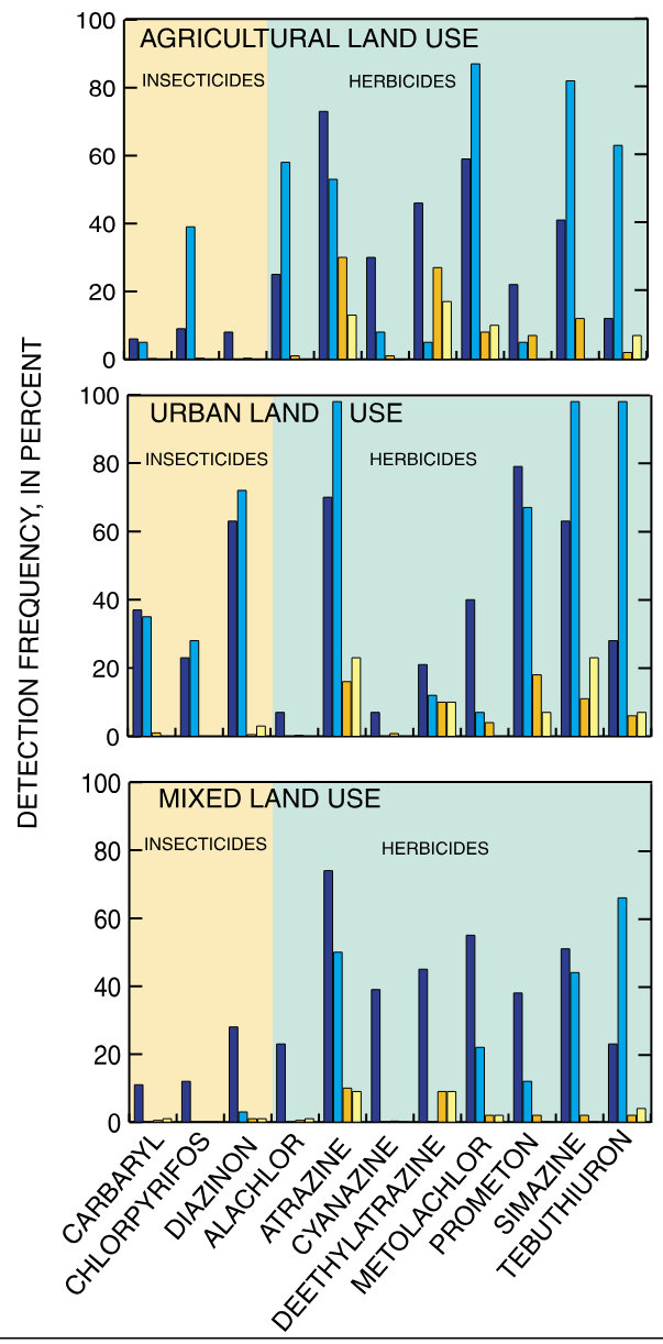
Water Quality in the Santee River Basin and Coastal Drainages Pesticides were detected more frequently in urban streams than in agricultural streams (fig. 5). The most commonly detected herbicides—simazine, prometon, atrazine, and tebuthiuron—were detected nearly twice as frequently in water samples collected at urban sites than at agricultural sites. Conversely, some herbicides such as metolachlor and alachlor were detected almost exclusively at agricultural sites.

Figure 5. Pesticides, particularly insecticides, were detected more frequently in urban streams than in agricultural streams.
Insecticides were detected about four times more frequently at urban stream sites than at agricultural stream sites, and aquatic-life criteria were exceeded in nine samples collected at urban sites and in three samples collected at agricultural sites. The insecticide diazinon was detected only in urban streams, whereas chlorpyrifos was detected frequently in both urban and agricultural streams. This agrees with national findings in which insecticides were detected more frequently in urban than in agricultural streams (U.S. Geological Survey, 1999).
These findings indicate that while agricultural activities contribute pesticides to surface water, concentrations are rarely high enough to affect aquatic life. The consequences of urban and suburban use of pesticides is much more significant, with concentrations of insecticides frequently at levels that can affect aquatic life.
Some herbicides showed patterns of occurrence that can be related to seasonal applications and weather patterns. At Gills Creek, an urban stream, concentrations of herbicides, such as atrazine, simazine, and tebuthiuron, peaked in the spring following application and gradually decreased over the summer (fig. 6). Atrazine and simazine followed a similar pattern at Cow Castle Creek, an agricultural stream, with the addition of a second peak in early fall. The highest concentrations at all sites were observed during storms that followed applications.
Understanding these patterns of occurrence is important because sampling programs need to be designed so that critical periods of high pesticide concentrations are monitored. This information also can be used by environmental managers to assess risk associated with agricultural chemical use.
Few Pesticides Were Detected in Drinking-Water Supply Aquifers
Of the 90 drinking-water, industrial, and irrigation supply wells sampled in the Floridan, Piedmont, and Sandhills aquifers, 17 had detectable concentrations of pesticides; of those, only two wells had pesticide concentrations that exceeded USEPA drinking-water standards (U.S. Environmental Protection Agency, 1996). Eleven of the 34 pesticides detected in drinking-water supply aquifers did not have water-quality standards.
The Sandhills aquifers are more susceptible to contamination than the other aquifers, as is illustrated by the larger number of pesticides detected and the higher detection frequency in the Sandhills aquifers than in the Piedmont and Floridan aquifers (fig.7). In addition, the two wells that had pesticide concentrations exceeding USEPA drinking-water standards were located in the Sandhills aquifers. Drinking water obtained from the Piedmont and Floridan aquifers is probably unlikely to contain pesticides at harmful levels; however, the high rate of detection and large number of pesticides detected in the Sandhills aquifers are a cause for concern.


Figure 6. Herbicide concentrations generally peaked following spring applications in Gills Creek, an urban stream.
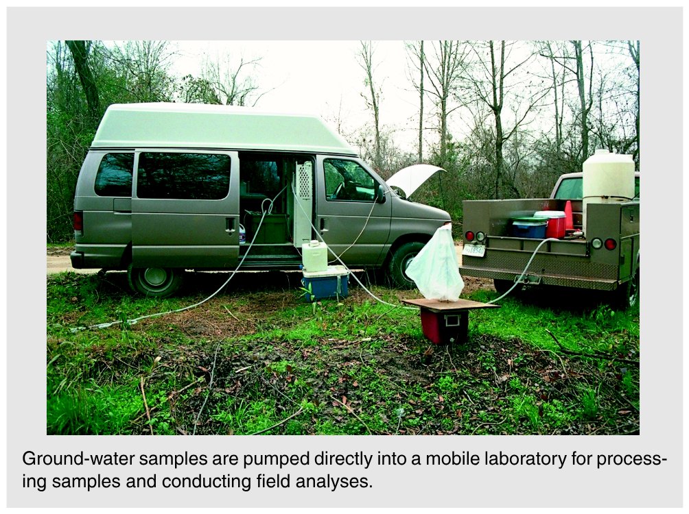
Figure 7. The large number of pesticides detected in the Sandhills aquifers illustrates its relatively high susceptibility to contamination.
Major Findings The differences in the rate and number of detections in the aquifers may be related to differences in aquifer properties. The Sandhills are largely composed of layers of coarse and fine sand with various quantities of clay. No continuous confining unit or soil layer overlies the aquifer to impede the movement of contaminants into ground water. At the other extreme, the Floridan aquifer has an overlying clay confining layer that impedes vertical movement of contaminants throughout much of its extent (Aucott and others, 1987). The Piedmont aquifer has an overlying layer of weathered bedrock that contains abundant clay. The thickness of this unit is highly variable, but generally it impedes rapid vertical movement of contaminants from land surface to ground water.
Pesticides Were Common in Shallow Ground Water in Urban and Agricultural Areas
Pesticides were detected in 24 of 30 shallow wells in urban areas and in 22 of 30 wells in agricultural areas (Reuber, 1999). Dieldrin concentrations exceeded drinking-water standards in four urban wells; however, the wells sampled were installed for monitoring purposes only and are not drinking-water supply wells. Dieldrin also exceeded aquatic-life standards in these four urban wells, and tebuthiuron concentrations exceeded aquatic-life standards in one agricultural well. Generally, ground-water concentrations are not compared to aquatic-life standards; however, these concentrations can be of concern because shallow ground water can discharge to streams, elevating the pesticide concentrations in surface water.
Water Quality in the Santee River Basin and Coastal Drainages Pesticides were detected in ground water in urban areas about twice as frequently as in agricultural areas (fig. 8). Some pesticides detected in urban and agricultural ground water were the same, although insecticides were detected more frequently in urban ground water. This was similar to national NAWQA findings. The insecticide most frequently detected at urban sites was dieldrin. Although its agricultural use was canceled in the mid-1970s, dieldrin (and aldrin, which breaks down to dieldrin) was used for termite control until the mid-1980s and is a persistent compound (Barbash and Resek, 1996). Dieldrin was also the most commonly detected pesticide in urban ground water nationally (U.S. Geological Survey, 1999).

Figure 8. Pesticides were detected more frequently at urban ground-water sites than at agricultural sites.
Organochlorine Pesticides Were Detected in Bed Sediment and Tissues
Fourteen pesticides were detected in streambed-sediment samples, and 21 of 24 sites sampled had at least one detectable pesticide. All of the pesticides detected in sediment were organochlorine insecticides, such as chlordane, dieldrin, mirex, and DDT and its derivatives. Many of these compounds had their agricultural uses cancelled more than 20 years ago, yet they still appear in sediment samples. The reason for this is because the compounds are persistent, or are highly resistant to chemical breakdown.
Of the compounds detected, only DDE, a breakdown product of DDT, exceeded guidelines for the protection of aquatic life. The guidelines were exceeded at three sites, all of which are in basins with a high percentage of agricultural land. In addition, DDT concentrations were only slightly below the aquatic guidelines at several sites. Comparisons of land use to concentrations of organochlorine pesticides generally did not show strong relations, primarily because these insecticides were used in both urban and agricultural settings (fig. 9). The only prominent relation is the uniformly low levels of these pesticides detected at forested sites where these chemicals were less likely to be used.

Figure 9. Bed sediment in forested settings has significantly lower total organochlorine pesticide concentrations than bed sediment in other land-use settings.
The same pesticides detected in sediments were also in clam and fish tissues. Concentrations measured were generally much higher in tissue than in sediment; however, a direct comparison of these concentrations may not be valid because of potential differences in exposure rates of sediment and fish, differences in uptake by sediment organic carbon and tissue, and partitioning in fish tissue.
Phosphorus Concentrations in Streams Frequently Exceeded USEPA Goals
Nutrients measured in streams in the Santee Basin, such as ammonia, nitrite, nitrate, phosphate, and orthophosphate, were elevated above background concentrations in areas affected by agricultural and urban runoff. Of these nutrients, the only one governed by a drinking-water standard is nitriteplus-nitrate nitrogen (hereinafter referred to as nitrate) because it is the only nutrient that directly affects human health. None of the surface-water samples had concentrations of nitrate that were above the drinking-water standard of 10 milligrams per liter (mg/L) (U.S. Environmental Protection Agency, 1996).
Phosphorus concentrations were above the USEPA goal in several rivers in the Santee Basin. For example, the flow-weighted mean annual concentration of total phosphorus in the South Fork Catawba River is about four times higher than the USEPA goal for streams entering a reservoir (U.S. Environmental Protection Agency, 1986) (fig. 10). This is important because many of the reservoirs in the Santee Basin are eutrophic; that is, they have high levels of nutrients that can result in excessive growth of algae (Stecker and Crocker, 1991). Much of the phosphorus and nitrogen that feeds the algae is carried into the reservoirs by major rivers. The South Fork Catawba River flows into Lake Wylie directly downstream of the sampling site and is the only stream sampled that enters directly into a reservoir.

Figure 10. Three streams in the Santee Basin frequently exceeded the U.S. Environmental Protection Agency goal for phosphorus in surface waters not entering reservoirs, and one exceeded the goal for waters entering reservoirs.
The USEPA also has a goal of 0.1 mg/L total phosphorus for
Water Quality in the Santee River Basin and Coastal Drainages streams that do not directly discharge to reservoirs (U.S. Environmental Protection Agency, 1986). The purpose of this goal is to prevent excessive plant growth in streams. Indian Creek, N.C., Congaree River, and Brushy Creek do not meet this goal based on mean annual concentrations (fig. 10). Only two of the streams sampled did not have at least one sample above the goal. These were Jacob Fork River and McTier Creek, both of which drain forested watersheds. The remaining streams had percentages of individual samples that exceeded the goal, ranging from 4 to 96 percent.
An analysis of nutrient data collected by State monitoring agencies during 1973–93 (Maluk and others, 1998) showed that all but 3 of 90 stream and lake sites exceeded the applicable phosphorus goal at least once, and 23 sites had median concentrations that exceeded the goal. Although 34 of the 90 sites showed decreasing trends in phosphorus concentrations, 53 showed no trend, and 3 had increasing trends.
For all the streams in the study unit, except in the South Fork Catawba River, there is a strong relation between orthophosphate (the predominant form of dissolved phosphorus in streams) concentrations and the percentage of agricultural land in the basins sampled (fig. 12). This relation most likely results from the runoff of phosphate-containing chemical fertilizer and manure from agricultural lands. The relation generally is not influenced by municipal waste-water discharges because phosphate-containing detergents have been banned for domestic use in the Santee Basin since the late 1990s (Litke, 1999).

Figure 11. The concentration of orthophosphate in streams is directly related to the percentage of agricultural land in the stream basin except for the South Fork Catawba River.
The South Fork Catawba River has much higher concentrations of orthophosphate than would be predicted from the amount of agricultural land in the basin (fig. 11). This may result from a lack of a phosphorus ban on industrial users. The South Fork Catawba River Basin contains a large concentration of industries that use phosphate detergents, which are a potential source for the high orthophosphate levels in the South Fork Catawba River (Lindsey and Lewis, 1994).
Water-Supply Aquifers Rarely Exceeded Drinking-Water Standards for Nitrate
With the exceptions of nitrate, most nutrient concentrations in ground water in the Santee Basin were low. This is fairly typical of ground water in which most forms of nitrogen and phosphorus are negligible (Nolan and Stoner, 2000).
Nitrate concentrations exceeded the USEPA (1996) drinking-water standard of 10 mg/L in 14 of the 150 wells sampled. Drinking water containing concentrations of nitrate above the standard can result in methemoglobinemia, a life-threatening illness. All but two of the wells that exceeded the standard were located in the shallow aquifer beneath agricultural land in the Coastal Plain. In fact, wells in the agricultural land-use study had the highest concentrations of nitrate overall, with concentrations up to 23 mg/L and a median concentration about double the national NAWQA median for agricultural land use (fig.12). Although the shallow aquifer generally is not used for drinking-water supplies, the potential for movement of nitrate-enriched water to deeper aquifers used for water supply is a cause for concern. Wells beneath urban land had lower median concentrations of nitrate than wells in agricultural lands and were lower than the national NAWQA median for urban land use.

Figure 12. Nitrate concentrations in shallow ground water in agricultural areas were higher than those in urban areas and in major aquifers.
Nitrate concentrations measured in the three drinking-water supply aquifers sampled in the Santee Basin were variable. The Piedmont had the highest nitrate concentrations, followed by the Sandhills and Floridan aquifers (fig. 13). Only two wells exceeded the drinking-water standard for nitrate, one each in the Piedmont and Sandhills aquifers. With the exception of these two wells, most concentrations measured were well within the standard. One of the wells with a concentration above the standard was an irrigation well located in the middle of a corn and soybean field; the other was adjacent to a golf course. These results suggest that most wells in these three aquifers are safe from high levels of nitrate, but some concern is justified for wells located near areas with high fertilizer use.
The higher nitrate concentrations in the Piedmont and Sandhills aquifers are related to the lack of con-
Major Findings finement for these aquifers, which readily allows the downward movement of surficial contaminants. Water in these aquifers often has high dissolved oxygen concentrations, which prevents denitrification (the removal of nitrate by conversion to nitrogen gas). By comparison, the Floridan aquifer has the lowest nitrate concentrations because it is confined, meaning little water moves vertically into the aquifer, and it has little dissolved oxygen, a condition which can promote denitrification.

Figure 13. The Piedmont and Sandhills aquifers had higher median nitrate concentrations than the Floridan aquifer.

Figure 14. Concentrations of nitrate are reduced through denitrification as ground water flows to Cow Castle Creek. Typical wells used for water supply in this area are greater than 100 feet deep. Nitrate concentrations at that depth generally are not above drinking-water standards.
Water Quality in the Santee River Basin and Coastal Drainages Local conditions can strongly affect the nitrogen concentrations in ground water and how much nitrate discharges from ground water to surface water. A study of the transport of nitrate in ground water was conducted at an agricultural site adjacent to Cow Castle Creek, S.C. (fig. 14). At this site, ground water beneath a corn field had concentrations of nitrate more than 28 mg/L, nearly three times the drinking-water standard. Along the ground-water flow path, nitrate concentrations decreased to less than 5 mg/L.
Directly below the streambed, nitrate concentrations were above 4 mg/L. However, as ground water moves upward to the stream, it passes through an organic-rich zone containing little dissolved oxygen. Denitrification occurring in this zone results in water with a nitrate concentration of only 0.4 mg/L.
Denitrification may not always be effective in removing nitrate at all locations where ground water discharges to Cow Castle Creek. This is evidenced by the high concentrations of nitrate measured in Cow Castle Creek during low flow when most streamflow is attributed to ground-water discharge.
PHOSPHORUS CONCENTRATIONS IN THE SANTEE BASIN WERE IN THE MIDDLE RANGE OF NATIONAL RESULTS

Bed Sediment Had Low MERCURY CONTAMINATION POTENTIAL IN Concentrations of Trace Elements SANTEE BASIN WAS HIGHEST IN NATION
Trace elements in bed sediment were detected frequently but mostly at concentrations below those expected to affect aquatic life (Canadian Council of Ministers of the Environment, 1995). Arsenic and lead exceeded aquatic standards in one sample each, and chromium exceeded standards in four samples. The samples with elevated chromium concentrations were not associated with any particular land use; however, most of these samples were collected at sites in the Piedmont. This suggests that the elevated concentrations may be naturally occurring as a result of geologic conditions in the Piedmont.

Regional differences in bed sediment trace-metal concentrations were observed in the study area. In general, a decrease in the bed-sediment concentrations of arsenic, chromium, copper, nickel, and zinc occurs from the Blue Ridge southeastward across the Piedmont to the Coastal Plain. In the same direction, an increase in the bedsediment concentrations of lead, mercury, and selenium occurs. These differences are likely a result of geologic differences among the areas (Abrahamsen, 1999).
A comparison of land use with bed sediment trace-element concentrations indicates that lead is significantly higher in sediment from urban streams than in sediment from forested streams. Neither agricultural nor mixed land-use streams had significantly higher concentrations of lead than forested streams (Abrahamsen, 1999).
Water Quality in the Santee River Basin and Coastal Drainages
Trace Elements Accumulated in Clam Tissue and Fish Livers
Trace metals are naturally occurring and were detected in all fish liver and clam tissue samples collected. Nine trace elements (arsenic, cadmium, chromium, copper, lead, mercury, nickel, selenium, and zinc) have been classified as priority pollutants because they are toxic to aquatic organisms in low concentrations (Code of Federal Regulations, 1996). Of these nine metals, concentrations of cadmium, copper, selenium, and zinc were higher in clams and fish liver tissue than those measured in sediment. Carp liver tissue contained significantly higher concentrations of these metals than those in clams and bed sediment, indicating that the metals accumulate in fish livers. Concentrations of arsenic, chromium, lead, and nickel were significantly lower in tissues than in sediment, suggesting that these metals do not accumulate in tissues (fig. 15). Concentrations of mercury were higher in clam tissue than in sediment and fish livers. Although data suggest that some metals accumulate in tissues, most metals do not have criteria for assessing risk to human health or aquatic wildlife associated with fish consumption.
Concentrations of mercury in clams and fish liver tissue from the Edisto River were 24 and 8 times greater, respectively, than the South Carolina action level for issuance of a fish-consumption advisory. Data collected in the NAWQA Program cannot be used to assess potential risk to human health because fish livers were used for analyses, whereas fish fillets are needed to assess humanhealth risk. Consumption advisories generally are not applied to clams because few humans consume them. The South Carolina Department of Health and Environmental Control (2000) has issued fish-consumption advisories because of high levels of mercury in 49 rivers and reservoirs in the Santee Basin, including the Edisto River.

Figure 15. Cadmium, copper, selenium, and zinc were detected at higher concentrations in clam and fish tissue than in sediment, suggesting that they accumulate in the tissues. Conversely, arsenic, chromium, lead, and nickel were detected in lower concentrations in tissues than in sediment, indicating that these metals do not accumulate in the tissues.
Radon Exceeded Proposed Standards in Many Wells
Ninety-six percent of the 90 wells sampled in drinking-water supply aquifers of the Santee Basin contained measurable quantities of radon, a colorless, odorless gas that can cause cancer in humans. The gas results from the radioactive decay of uranium in rocks and soil and can enter homes directly from the soil or in drinking water supplied by wells. Radon is a health risk through direct inhalation of the gas and from drinking water contaminated with radon.
Of the 90 wells sampled, radon exceeded the USEPA’s (1999) proposed maximum contaminant level (MCL) of 300 picocuries per liter (pCi/L) in 100, 47, and 17 percent of the wells in the Piedmont, Sandhills, and Floridan aquifers, respectively (fig. 16). For wells not meeting the MCL, the USEPA has proposed an Alternative Maximum Contaminant Level (AMCL) of 4,000 pCi/L. To comply with the

Figure 16. Radon concentrations were highest in the Piedmont and Sandhills aquifers, resulting from naturally high levels of uranium in near-surface rocks and sediment.
RADON CONCENTRATIONS WERE HIGH IN THE SANTEE BASIN

Radon concentrations in the Santee Basin were among the highest measured in the Nation. These high concentrations result from radioactive decay of naturally occurring minerals in the soil and rock that underlie the study area and compose the aquifer in the Piedmont part of the study area. The Piedmont metamorphic rocks are present in many eastern coastal States and probably account for the high radon concentrations observed in Study Units located in those States.
Water Quality in the Santee River Basin and Coastal Drainages AMCL, the State or local water utility must develop indoor air radon-reduction programs and reduce radon levels in drinking water to 4,000 pCi/L. Of the wells that were sampled in the Piedmont, Sandhills, and Floridan aquifers, 20 percent, zero percent, and less than 1 percent, respectively, exceeded the proposed AMCL.
Wells in the Piedmont had much higher concentrations of radon, on average, than wells sampled in the Sandhills and Floridan aquifers (fig. 16). This results from the greater relative abundance of minerals containing uranium in the metamorphic rocks that compose the Piedmont aquifer. The same bedrock underlies the Sandhills and Floridan aquifers, but generally at depths ranging from several hundred to several thousand feet.
Volatile Organic Compounds Were Common in Urban Ground Water
All but 3 of 30 monitoring wells installed in commercial and residential areas of Columbia, S.C., contained a variety of volatile organic compounds (VOCs), a group of chemicals that includes gasoline additives, solvents, and disinfection by-products (Reuber, 1999). Thirty-five such compounds were detected. Most wells contained three or more VOCs, and one well contained 15 different VOCs.
Most of the VOC detections were at extremely low levels. The five VOCs detected with the highest concentrations were methyl tert-butyl ether (MTBE), trichloroethene (TCE), acetone, tert-amyl methyl ether (TAME), and trichloromethane. Of the 35 detected VOCs, 14 have established drinking-water standards; of these, only TCE exceeded the standard. Currently there is no standard for MTBE, but the MTBE concentration in one well exceeded a drinking-water advisory.
Some of the most frequently detected compounds included trichloromethane, chloromethane, and bromodichloromethane. These compounds can result from the chlorination of drinking water and can enter ground water by infiltration from irrigation systems or from leaky water-supply lines. Other VOCs that were detected were solvents, such as TCE, tetrachloroethene, and acetone. These compounds have commercial and industrial uses as degreasers and dry-cleaning solvents, but they are often used in households for similar purposes. The gasoline additives MTBE and TAME and the gasoline component benzene also were detected in Columbia’s ground water. These compounds can enter ground water from leaking gasoline storage tanks, spills, and potentially through atmospheric deposition (Lopes, 1998).
The diffuse, nonpoint nature of sources of VOCs in ground water makes it difficult to attribute detected compounds to particular homes or businesses, posing a problem for scientists who seek to establish the relative importance of these sources and for regulators who seek to educate the public or control the release of toxic substances.
Ten VOCs were detected in seven monthly stream-water samples that were collected from Gills Creek, an urban stream in the Columbia metropolitan area. MTBE, chloromethane, methylbenzene, chlorobenzene, and acetone were detected most frequently. None of the VOCs detected in Gills Creek were at concentrations exceeding drinking-water or aquatic-life standards. Six of the VOCs detected do not have standards.
VOCs have many sources, including contaminated precipitation, surface-water runoff, and ground-water discharge. Though the sources are diffuse and hard to measure directly, inferences can be made about the likely sources. For example, samples collected in Gills Creek while the water level was rising during a rainstorm indicate that as streamflow increased, the concentration of acetone increased. This suggests that the source of acetone in the samples was from contaminated precipitation or stormwater runoff (Lopes and others, 2000). If the acetone resulted from continuously discharging ground water, the concentration would be expected to decrease as dilution by rainfall and runoff increased.
Major Findings During the summer of 1996, 20 different VOCs were detected at low concentrations in individual samples collected at 16 surface-water sites scattered throughout the Gills Creek Basin. The compounds detected in the highest concentrations included MTBE, 1,1-dichloroethene, trichloroethene, methylbenzene, and 1,2-dibromo-3-chloropropane—all solvents except for MTBE, which is a gasoline additive. Fifteen of the compounds detected in surface water also were present in the Columbia ground-water samples. This result is not surprising because the samples were collected during low streamflow conditions when the ground-water contribution to Gills Creek is greatest; consequently, VOCs from contaminated ground water most likely would be detected in stream samples.
Water Quality in the Santee River Basin and Coastal Drainages
Drinking-Water Aquifers Had Low Concentrations of Volatile Organic Compounds
Of the 90 wells sampled in the Piedmont, Sandhills, and Floridan aquifers, 62 contained detectable concentrations of VOCs. All of the 28 compounds detected met USEPA drinking-water standards; however, 19 of the compounds did not have standards. The VOCs measured had widely ranging detection limits, making comparisons among compounds and aquifers difficult. A subset of the compounds having detection limits of 0.05 microgram per liter (μg/L) or lower was used to make comparisons. This comparison shows that
Ground water affects the quality of surface water
about twice as many wells in the Sandhills aquifers contain VOCs as those in the Floridan and Piedmont aquifers. The more frequent occurrence of VOCs in the Sandhills aquifers probably relates to their greater susceptibility to contamination.
Data on VOCs in drinking-water aquifers indicate that although these compounds are widespread, concentrations are sufficiently low that human health is not immediately at risk. However, the fact that detections were so frequent suggests that aquifers are susceptible to contamination and should be carefully monitored.
Urban and Agricultural Streams Had High Concentrations of Bacteria
Thirteen of 17 streams sampled for fecal coliform bacteria had at least one sample that exceeded the South Carolina single-sample standard of 400 colonies per 100 milliliters (cols/100 mL; South Carolina Department of Health and Environmental Control, 1992). This standard was implemented to reduce the risk of gastrointestinal disorders that are associated with recreational contact with water containing elevated levels of bacteria. All concentrations measured in this report were compared to South Carolina standards for consistency; North Carolina does not recognize a single-sample standard.
Urban and agricultural streams had more concentrations of bacteria that exceeded standards than forested and mixed land-use streams (fig. 17). Several creeks repeatedly had high concentrations of bacteria. For example, one of the urban streams sampled, Brushy Creek, exceeded the standard in 60 percent of the samples collected.

Figure 17. Urban and agricultural streams had more concentrations of bacteria that exceeded South Carolina State standards than forested and mixed land-use streams.
The highest bacterial concentrations measured were at agricultural sites, such as Cow Castle Creek and Indian Creek, N.C., which had concentrations of 21,600 and 12,000 col/100 mL, respectively. The highest concentrations observed in urban streams were much lower—around 2,000 col/100 mL. Forested streams generally had the lowest peak concentrations, ranging from about 500 to 1,000 col/100 mL. Samples were collected under all flow conditions, and higher concentrations as well as standard exceedances tended to occur at higher streamflows.
All of the regularly monitored small streams exceeded the South Carolina single-sample standard for bacteria. Most large rivers did not exceed the standard during the period sampled, including the Wateree, Saluda, Congaree, and Edisto Rivers. The median bacterial concentrations in streams with drainage areas larger than 100 square miles (mi) were significantly lower than those in streams with drainage areas less than 100 mi. Because major rivers and small streams have similar sources of bacteria, the most likely reason for the differences in bacterial levels is dilution by the larger flows in the major rivers.
A comparison of bacterial concentrations to the physical and chemical parameters of the water indicate that surface-water runoff accounts for much of the elevated fecal coliform concentrations (Wilhelm and Maluk, 1998). Bacterial concentrations increased as streamflow, organic nitrogen, organic carbon, phosphorus, and suspended-sediment concentrations increased. Because increases in these parameters usually result from surface-water runoff, the implication is that the increase in bacteria also resulted from runoff.
In agricultural areas, bacteria in runoff may result from applications of manure to fields and from animal holding and feeding areas. Urban sources include runoff from lawns containing pet wastes, leaking or failed septic tanks and sewer lines, and municipal or industrial discharges. Bacterial contamination in forested areas most likely results from fecal contamination by wildlife.
Biological Communities Reflected Land-Use Differences
Biological communities that inhabit streams in Santee Basin agricultural and urban areas were indicative of degraded water quality compared to those that inhabit streams that drain forested areas. Fish that have a low tolerance for contamination make up a smaller percentage of the fish community at agricultural and urban sites than at forested sites (fig. 18). This can result because fish such as darters and shiners that are sensitive to contaminants do not thrive at degraded sites. Other species such as catfish, redbreast sunfish, and some minnows that are relatively unaffected by contaminants will take the place of the more sensitive fish.
Urban and agricultural streams also had lower numbers of invertebrate species that are intolerant of contaminants than forested and mixed land-use streams. This is evidenced by the lower numbers of Ephemeroptera, Plecoptera, and Trichoptera (EPT) taxa, a group of aquatic insects that are relatively intolerant of contamination, at urban and agricultural sites. The USEPA (Plafkin and others, 1989)
Water Quality in the Santee River Basin and Coastal Drainages uses the presence or absence of EPT taxa as an indicator of aquatic community health.

Figure 18. Compared to forested sites, urban and agricultural sites have higher concentrations of atrazine and ammonia as well as lower numbers of fish and invertebrates that are intolerant of contamination.
Water-quality constituents and contaminant-intolerant species are related (fig.18). Median concentrations of ammonia, a nutrient associated with wastewater discharges, and atrazine, an agricultural and turfgrass herbicide, are highest at urban and agricultural sites, corresponding to low numbers of contaminant-intolerant fish and invertebrate species. This suggests that these water-quality constituents have an effect on the aquatic community; however, other factors, primarily those associated with aquatic habitats, can affect aquatic community health in ways that are similar to those that result from changes in water quality. In addition, sample sites were located in several different physiographic provinces, including the Blue Ridge, Piedmont, and Coastal Plain. Differences in species distributions and habitat in these different settings can make comparisons difficult to interpret. Most likely, a combination of water quality and habitat disturbance associated with agricultural and urban land uses results in the observed differences in biological communities.
Algal Siltation Index

Invertebrate Status Index

STREAM CHEMISTRY AND BIOLOGY
Fixed sites were sampled to examine differences in streamwater quality due to the environmental setting, a combination of land use, geology, physiography, and climate. Intensive fixed sites were a subset of fixed sites that were sampled more frequently to determine the occurrence and seasonal variability of pesticides. Aquatic community structure, including algae, fish, and macroinvertebrates, was studied at each fixed site to quantify the effects of water quality on stream biota. Synoptic studies focused on low streamflow conditions in an urban setting in Gills Creek, S.C., and a mixed land-use setting in the South Fork Catawba River Basin, N.C. Streambed sediments and fish and clam tissues were sampled to determine the occurrence and distribution of trace elements and organic compounds.

SPECIAL STUDIES
The effects of a forested wetland on nutrient concentrations in stream water were studied as part of the Forested Wetland Initiative, a joint research project with the U.S. Forest Service. Baseline data on water quality and aquatic communities were collected in cooperation with the National Park Service at Congaree Swamp National Monument (Maluk and Abrahamsen, 1999). A study to determine the accumulation of mercury in fish tissues was conducted in the Edisto River Basin.
Water Quality in the Santee River Basin and Coastal Drainages

GROUND-WATER CHEMISTRY
Subunit surveys were conducted in three drinking-water supply aquifers to assess overall water quality. Land-use studies in urban and agricultural settings evaluated the effects of these land uses on shallow ground water. An agricultural flow-path study examined the transport and fate of nutrients and pesticides in shallow ground water. Study Unit Design


GLOSSARY
Water Quality in the Santee River Basin and Coastal Drainages
APPENDIX—WATER-QUALITY DATA FROM THE SANTEE RIVER BASIN AND COASTAL DRAINAGES IN A NATIONAL CONTEXT

Water Quality in the Santee River Basin and Coastal Drainages Water-Quality Data in a National Context Water Quality in the Santee River Basin and Coastal Drainages Water-Quality Data in a National Context Water Quality in the Santee River Basin and Coastal Drainages Water-Quality Data in a National Context Water Quality in the Santee River Basin and Coastal Drainages

U.S. Geological Survey Circular 1206


Where this page came from
This page was imported from U.S. Geological Survey. Published by the U.S. Geological Survey and, as a work of the United States government, in the public domain.
Nobody has written it yet — it is the source material at a new address, which is why search engines are asked to skip it and why no one earns from it. It is up for grabs: take it on, and it is yours to rewrite and to earn from.
Licence: CC0 1.0 (public domain) · Adapted from pubs.usgs.gov
1
0
0
0

Comments


