
Viu algo para melhorar? Proponha uma alteração.
National Water-Quality Assessment, Transport of Anthropogenic and Natural Contaminants (TANC) to Public-Supply Wells
The U.S. Geological Survey’s National Water-Quality Assessment (NAWQA) Program found, in studies from 1991 to 2001, low levels of mixtures of contaminants in groundwater near the water table in urban areas across the Nation. Although contaminants were detected less frequently in deeper groundwater typically developed for public supply (Hamilton and others, 2004), the proximity of contaminant mixtures to underlying public water-supply sources prompted the NAWQA Program to begin intensive studies in 2001 to assess the vulnerability of public-supply wells to contamination. Specifically, the pathways and processes by which contaminants reach public-supply wells in nine aquifer systems across the country are being investigated. Scientists are studying the processes that occur below land surface—whereby contaminants are mobilized or attenuated—as well as investigating how human activities can affect the vulnerability of public-supply wells to contamination.

This fact sheet highlights findings from the vulnerability study of a public-supply well in Modesto, California (Burow and others, 2008; Jurgens and others, 2008). The well selected for study pumps on average about 1,600 gallons per minute from the Central Valley aquifer system during peak summer demand. Water samples were collected at the public-supply well and at monitoring wells installed in the Modesto vicinity (see “Study Design” sidebar on next page). Samples from the public-supply wellhead contained the undesirable constituents uranium, nitrate, arsenic, volatile organic compounds (VOCs), and pesticides, although none were present at concentrations exceeding drinking-water standards. Of these contaminants, uranium and nitrate pose the most significant water-quality risk to the public-supply well because human activities have caused concentrations in groundwater to increase over time. Some of the contaminants found in untreated water from the public-supply well are anthropogenic (introduced by human activity); others occur naturally. Specifically, elevated concentrations of nitrate and the presence of pesticides are commonly linked with intensive, irrigated agriculture. VOCs are commonly used as solvents or gasoline components in urban and residential areas. Uranium and arsenic occur naturally in alluvial sediments.
Overall, NAWQA findings point to four primary factors that affect the movement and (or) fate of contaminants and the vulnerability of the public-supply well in Modesto: (1) groundwater age (how long ago water entered, or recharged, the aquifer); (2) irrigation and agricultural and municipal pumping that drives contaminants downward into the primary production zone of the aquifer; (3) short-circuiting of contaminated water down the public-supply well during the low-pumping season; and (4) natural geochemical conditions of the aquifer. Study findings are intended to help water managers, drinking-water suppliers, policymakers, and scientists better understand how and why contamination of public-supply wells occurs and whether water quality may improve or degrade. Additionally, study findings may be used to evaluate various pumping, resourcedevelopment, and land-management scenarios.
Mixing of Young Water with Older Water Increases Well Vulnerability
“Groundwater age” refers to the elapsed time since water entered an aquifer at the water table. Because water in an aquifer typically flows downward and laterally over time, it is expected that “young” water (water that reached
Study Design
the water table less than 50 years ago) will be found closest to the water table and older water (water that recharged 50 or more years ago) will be found at greater depths. The presence and proportion of young water relative to old water produced by the public-supply well is of interest because young groundwater is more vulnerable to contamination from human activities in urban and agricultural areas than is older groundwater, which recharged before manmade chemicals became prevalent.
As is typical of a production well, the long screened interval of the public-supply well (275 feet) captures a mixture of water that recharged at different times. To understand the resulting blend of water of different ages (or “age distribution of water”) produced by the public-supply well, a computer-model simulation of groundwater flow and transport was used to calculate the traveltime (or age) of water particles entering the well along the length of the well screen. Modeled findings show that simulated ages of water particles reaching the public-supply well range from 9 years to more than 30,000 years. Most of the water is at the young end of this range (fig. 1), resulting in a median age of 54 years. The age of water particles entering the well generally increases with depth; however, there are small perturbations in this trend where younger water enters beneath slightly older water, due primarily to the heterogeneity of the aquifer sediments. For example, overlapping lenses of coarse-grained sediments may transmit water to depth more rapidly than a flow path that intersects silt and clay lenses. Figure 2 shows areas where water that eventually reaches the public-supply well enters the groundwater system, along with the traveltimes associated with the water particles. The shortest traveltimes are not always associated with particles that recharged closest to the well, due in part to the heterogeneity of the aquifer sediments.
Groundwater-quality data also were used to interpret water ages. Concentrations of modern age tracers (sulfur hexafluoride and tritium) increased in the atmosphere—and also in precipitation—within the last four or five decades as a result of human activities. Thus, groundwater containing these tracers is considered to be young, having entered the groundwater system within the last 50 years. Results of water sampling for modern age tracers and other chemical constituents revealed that water quality in the aquifer is stratified into shallow, intermediate, and deep zones having distinct chemistry (fig. 3). Water in the shallow zone—defined as less than 164 feet (50 meters) below land surface—has a mean age between 30 and 40 years based on modern age-tracer data and has been highly affected by human activities. Specifically, water samples from shallow monitoring wells and the shallow depthdependent sample from the public-supply well have much higher specific conductance and concentrations of alkalinity, nitrate, sulfate, and uranium than samples collected from the intermediate and deep zones, and also more frequent detections and higher concentrations of VOCs and pesticides. The uranium concentration (35.8 micrograms per liter (μg/L)) in the sample of shallow water entering the public-supply well exceeded the 30-μg/L Maximum Contaminant Level (MCL) allowed in drinking water by the U.S. Environmental Protection Agency, and the nitrate concentration (9.7 milligrams per liter (mg/L)) was near the MCL of 10 mg/L. Most contaminants that reach the public-supply well enter from the shallow zone of the aquifer. Measurements of the flow rate of fluids entering the well at different depth intervals indicate that water from the shallow zone supplies less than 20 percent of the groundwater entering the well (fig. 3).
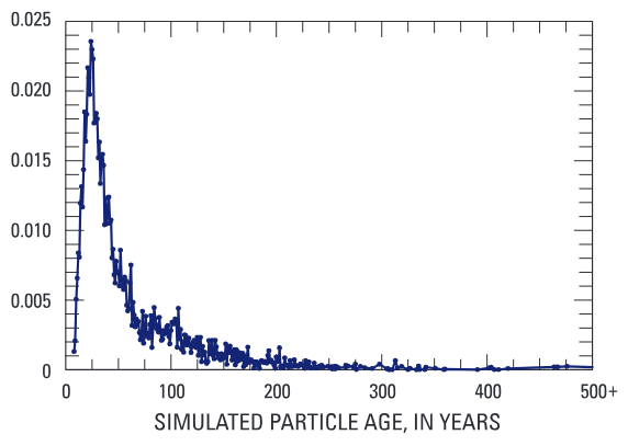

Figure 1. A groundwater flow model was used to simulate age distribution of water (the mixture of water of different ages) produced by the selected supply well in Modesto, California. “Age” refers to the time elapsed since water entered the groundwater system as recharge at the water table.
The remaining 80 percent of water entering the well comes from the deep and intermediate zones of the aquifer. Water in the deep zone of the aquifer was estimated to be thousands of years old and contained no anthropogenic contaminants. Nitrate, uranium, and alkalinity were at concentrations consistent with recharge under more natural conditions (fig. 3). Water in the intermediate zone is a mixture of young, anthropogenically affected water and older, more pristine water.
Groundwater Development Drives Contaminants Downward Into Production Zone of Aquifer
Downward groundwater flow exists year-round in the Modesto area, but the summertime application of irrigation water at land surface (for agricultural crops and urban landscapes) combined with water withdrawal at depth by well intakes has intensified this downward flow component, as indicated by the greater vertical gradient measured during the growing season (0.11) than during the winter (0.04) at a monitoring well in the Modesto area. The downward-moving irrigation waters contain manmade contaminants, and the particular types of contaminants in those waters are influenced by land-use practices. For example, findings from wells screened near the water table show that nitrate and sulfate concentrations were higher beneath land that was being farmed or had recently been farmed (within the last 10 to 20 years) than beneath urban areas. This is attributed to common agricultural practices near Modesto that include applications of nitrogen fertilizers to increase crop yields and gypsum soil amendments to promote infiltration. In contrast, VOCs—which have many commercial and household uses—were typically found only beneath urban areas.
Agricultural development near Modesto has been accompanied by an increase in alkalinity and uranium in shallow groundwater. Alkalinity is a measure of the capacity of water to resist changes in pH; in the study area this capacity comes primarily from bicarbonate in groundwater as a result of mineral dissolution. In 1910, when precipitation and seepage from streams near the mountain front were still the dominant forms of recharge to the aquifer and natural vegetation predominated, shallow groundwater in the area had an alkalinity of about 110 mg/L as calcium carbonate (Mendenhall and others, 1916). In contrast, in 2003 and 2004—when the primary source of recharge was percolating excess irrigation water and natural vegetation had been replaced by crops (Burow and others, 2004)—the median alkalinity of shallow groundwater was 309 mg/L. Because mineral dissolution is enhanced by plant and microbial processes in the soil zone and by increased moisture, increased crop production coupled with increasing amounts of irrigation in the 1940s and 1950s likely began to move high-alkalinity water from the soil zone, into the aquifer, and downward through the shallow groundwater flow system. A statistically significant correlation between alkalinity and nitrate concentrations supports this hypothesis. Below the shallow zone of the aquifer, alkalinity concentrations are roughly equivalent to those before agricultural development, with median concentrations in the intermediate and deep zones of 146 and 85 mg/L, respectively (fig. 3).
Downward movement of high-alkalinity water is of concern to water managers because alkalinity (which has no health-related drinking water standard) was strongly correlated with uranium (which has a MCL of 30 μg/L, based on human health concerns). The current study found that uranium concentrations in groundwater beneath urban and agricultural land near Modesto were similar, suggesting concentrations are not related to land use. Instead, the downward-moving front of high-alkalinity water liberates naturally occurring uranium that is adsorbed to aquifer sediments. This causes uranium concentrations in shallow groundwater to be elevated (median concentration of 24 μg/L). Concentrations of bicarbonate ions that chemically bond with uranium decrease below 164 feet because the groundwater at these depths recharged before intensive irrigation began. Below 164 feet, lowalkalinity conditions favor adsorption of uranium to aquifer sediments, resulting in much lower uranium concentrations in the aquifer’s intermediate zone (median of 4 μg/L) and deep zone (median of 0.5 μg/L) than in the shallow zone (fig. 3).
Currently, the shallow water entering the public-supply well contains elevated concentrations of uranium and nitrate, but these concentrations are diluted within the well by the older water that makes up 80 percent of the flow to the well; so, concentrations at the wellhead are less than drinking-water standards. As irrigation and agricultural and municipal pumping continue to drive the movement of anthropogenically affected water downward to greater depths in the aquifer, the ratio of affected water to older, unaffected water will increase in the future, reducing dilution and thereby adversely influencing drinking-water quality.
Natural Geochemical Conditions in Aquifer Affect Fate of Contaminants
Geochemical conditions such as oxygen content of groundwater control whether specific contaminants are attenuated or mobilized in the subsurface. Dissolved oxygen is present in all groundwater samples from the Modesto area at concentrations greater than 1.5 mg/L, indicating that most of the aquifer is oxic. Oxic conditions can be attributed to the scarcity of organic carbon in the aquifer—when organic carbon is available, microbial respiration consumes oxygen—and also to the input of oxygenated irrigation water. In oxic conditions, nitrate is mobile in the groundwater system. Because of the mostly downward movement of water in the study area, nitrate in shallow groundwater near Modesto is likely to continue moving to greater depths in the aquifer without significant attenuation.
Construction and Operation of Public-Supply Well Affects Drinking Water Quality
Water samples were collected from five depths in the public-supply well. Surprisingly, the deepest sample from the public-supply well (320 feet below land surface) contained higher concentrations of nitrate and uranium and had a higher specific conductance than did most samples from monitoring wells screened at a similar depth. Because the screen of the public-supply well extends through all three zones of the aquifer and because a downward component of groundwater flow exists year-round in the Modesto area, NAWQA researchers determined that anthropogenically influenced water from the shallow zone can migrate down the public-supply well and into the deep zone of the aquifer when the well pump is turned off (fig. 4). This type of leakage is prevalent during the winter, when the public-supply well is pumped for only a short duration each day. During the several hours that the pump is off, large volumes of anthropogenically affected water accumulate in the deep aquifer. When the pump is briefly activated, the lift of the pump overcomes the downward flow gradient, and the contaminated water that is stored in the deep zone of the aquifer is drawn back toward the well. The result is that, during winter, anthropogenically affected water simultaneously enters the well from both the shallow and the deep zone of the aquifer, composing up to 45 percent of flow to the well compared to about 20 percent (from the shallow zone alone) during summer. When the public-supply well is pumped more frequently and for longer periods once the growing season starts, down-well leakage of water from the shallow zone is minimized, and affected water that has accumulated near the well in the deep aquifer over the winter is eventually evacuated, allowing clean water to once again enter the well from the deep aquifer. Thus, water quality produced by the well improves during the summer.

Figure 3. The portion of the aquifer tapped by the public-supply well was divided into shallow, intermediate, and deep zones based on water chemistry. The shallow zone has been highly affected by irrigation (both agricultural and urban) that is driving anthropogenic contaminants downward. Water-quality in the deep zone represents water recharged under more natural conditions.
Supporting evidence for the well leakage theory is (1) an examination of the seasonal fluctuations in the historic water-quality record for the supply well, with higher concentrations of nitrate, uranium, specific conductance and other anthropogenic compounds (chloroform, perchloroethylene, and deethylatrazine) produced during winter; (2) similar seasonal fluctuations in water quality of a deep monitoring well within 130 feet of the public-supply well that is apparently sampling the leaked water stored in the deep zone, and (3) seasonal fluctuations in the age of water discharged by the public-supply well, with a greater proportion of young water produced in winter. Because about a third of the irrigation and public-supply wells in the Modesto area have screens that span from the shallow to the deep zone of the aquifer, it is likely that leakage of anthropogenically affected water down production wells occurs at other locations in the Modesto area.
Protection Effort Implications
Pumping schedule of the public-supply well affects water quality. Well-field operators in Modesto noted that pumping for longer periods of time during winter months (with less downtime between pumping events) improved water-quality during these months. Previously, when the well was pumped for only a short duration each day in winter, it captured contaminated water that had migrated into the deep zone of the aquifer and resulting wellhead concentrations of nitrate and uranium sometimes exceeded regulatory levels. Pumping for longer periods minimizes the flow of anthropogenically affected water down the borehole. It also evacuates the contaminated water from the deep zone of the aquifer and allows clean water to enter the well and dilute high nitrate and uranium concentrations from the shallow zone, thereby bringing the concentrations back within drinking water standards.
Screened interval of a public-supply well affects its vulnerability. The median depth of public-supply wells in the Modesto area is 268 feet. Because the particular supply well selected for study is deeper (366 feet) and has a screen that intersects a greater portion of the deep aquifer zone than most of these wells, it produces a greater proportion of old groundwater than most other public-supply wells. It is likely that concentrations of uranium and nitrate will be higher in other wells that have shallower screened intervals and thus have a large proportion of relatively young, anthropogenically affected water contributing to the well and a correspondingly smaller proportion of dilute, older water. Historically, water from some public-supply wells in Modesto has periodically exceeded the MCL for nitrate. Several public-supply wells had to be abandoned for drinking-water use because uranium concentrations exceeded the MCL.
Past land use within the contributing recharge area may affect quality of water produced by the public-supply well for decades. Most of the contributing recharge area (CRA) for the selected public-supply well lies beneath land that is currently urban. However, urbanization of the area is relatively recent, beginning in about 1960; water older than about 40 years was affected primarily by agricultural practices at the time of recharge. The effect of changing land-use practices over time on long-term nitrate concentrations in the public-supply well was estimated from the simulated age distribution of water produced by the public-supply well to determine proportions of water recharged in different years. Assumptions in the simulation were (1) all land use was agricultural until 1960 and (2) between 1960 and 2004, the proportion of agricultural input in the CRA decreased and the proportion of urban input increased at an estimated rate of about 1 to 2 percent per year. Nitrate input concentrations in agricultural recharge water over time were estimated from nitrogen fertilizer application rates in the Modesto area, which steadily increased from the 1940s through the mid-1970s. Nitrate input concentrations estimated this way for the year 2004 were consistent with measured nitrate concentrations in wells screened near the water table beneath agricultural areas (median of 15 mg/L). Nitrate concentrations in recharge beneath the urban area was assumed to be 3.1 mg/L, based on water samples collected near the water table in 2004. Results of the simulation indicate that concentrations in the public-supply well peaked in the late 1990s and will decrease slightly from current levels of 5.5 mg/L to near 5 mg/L in the public-supply well during the next 100 years (fig. 5). This prediction is valid only if nitrate input beneath the growing urban area remains low and nitrate input beneath the agricultural area does not increase significantly (owing to increase in application rates of nitrogen fertilizer). Wells installed beneath a high proportion of agricultural land or recently converted agricultural land will likely have higher concentrations of nitrate than the public-supply well in this investigation.

Figure 4. During winter when the pump is off for several consecutive hours, contaminated water from the shallow zone of the aquifer travels down the well or gravel pack and exits at the base of the well screen into the deep aquifer. When the pump is activated for a short time each day, some of this leaked water is recaptured by the well. Prolonged pumping during summer evacuates contaminated water from the deep zone, and water quality of the public-supply well improves.

Figure 5. Temporal changes in nitrogen concentrations in recharge water were estimated from changes in land use and application rates of nitrogen fertilizer in the Modesto area. Resulting changes in the concentration of nitrate in water discharged from the well over time were then simulated. Simulation results indicate that nitrate concentrations in the well water peaked in the late 1990s, lagging about 25 years behind the peak nitrate concentration in recharge water.
The simulated long-term nitrate concentrations in the public-supply well reflect a lag time of 20 to 30 years between peak concentrations in recharge and peak concentrations in the well. This apparent delay between input at land surface and output at the well is the result of the wide range of ages of water reaching the public-supply well combined with the changing nitrogen input concentrations over time. This indicates that protection efforts in the Modesto area that rely on changes in land-use management to improve water quality may take 20 to 30 years to bring about results in drinking-water quality.
Uranium concentrations will continue to increase unless new management strategies are developed. High-alkalinity, high-uranium water is expected to continue moving deeper in the groundwater system over time, gradually composing an increasing proportion of the water entering the public-supply well. The effect of the downward-moving
By Martha L. Jagucki, Bryant C. Jurgens, Karen R. Burow, and Sandra M. Eberts For more information on the Transport of Anthropogenic and Natural Contaminants to Supply Wells (TANC) topical study, see
http://oh.water.usgs.gov/tanc/NAWQATANC.htm water on long-term uranium concentrations in the public-supply well was estimated by using traveltimes derived from the groundwater flow model to determine the proportions of water entering the supply well that recharged in different years. Then, an alkalinity-input history was estimated based on the assumption that alkalinity concentration in recharge was 110 mg/L prior to 1945 and then increased linearly to current concentrations of about 450 mg/L at the water table. Alkalinity input in the future was assumed to remain at current conditions. The resulting simulation indicates that concentrations of uranium in the public-supply well (based on a defined relation between uranium and alkalinity concentrations) will likely approach the MCL over time; however, it will take more than 100 years because of the contribution of old water at depth in the public-supply well that dilutes uranium concentrations in shallower water entering the well. This allows time to evaluate management strategies and to alter well-construction or pumping strategies to prevent concentrations from exceeding the drinking-water standard.
References
Burow, K.R., Jurgens, B.C., Kauffman, L.J., Dalgish, B.A., Phillips, S.P., and Shelton, J.L., 2008, Simulations of ground-water flow and particle pathline analysis in the zone of contribution of a public-supply well in Modesto, eastern San Joaquin Valley, California: U.S. Geological Survey Scientific Investigations Report 2008–5035, 41 p.
Burow, K.R., Shelton, J.L., Hevesi, J.A., and Weissmann, G.S., 2004, Hydrogeologic characterization of the Modesto area, San Joaquin Valley, California: U.S. Geological Survey Scientific Investigations Report 2004–5232, 54 p.
Hamilton, P.A., Miller, T.L., and Myers, D.N., 2004, Water quality in the Nation’s streams and aquifers—Overview of selected findings, 1991–2001: U.S. Geological Survey Circular 1265, 20 p.
Jurgens, B.C., Burow, K.R., Dalgish, B.A., and Shelton, J.L., 2008, Hydrogeology, water chemistry, and factors affecting the transport of contaminants in the zone of contribution of a public-supply well in Modesto, eastern San Joaquin Valley, California: U.S. Geological Survey Scientific Investigations Report 2008–5156, 78 p.
Mendenhall, W.C., Dole, R.B., and Stabler, Herman, 1916, Ground water in San Joaquin Valley, California: U.S. Geological Survey Water-Supply Paper 398, 310 p.
Phillips, S.P., Burow, K.R., Rewis, D.L., Shelton, J.L., and Jurgens, B.C., 2007, Hydrogeologic settings and groundwater flow simulations of the San Joaquin Valley regional study area, California, sec. 4 in Paschke, S.S., ed., Hydrogeologic settings and groundwater flow simulations for regional studies of the transport of anthropogenic and natural contaminants to public-supply wells—Studies begun in 2001: U.S. Geological Survey Professional Paper 1737–A, p. 4–1 through 4–31.
Where this page came from
This page was imported from U.S. Geological Survey. Published by the U.S. Geological Survey and, as a work of the United States government, in the public domain.
Nobody has written it yet — it is the source material at a new address, which is why search engines are asked to skip it and why no one earns from it. It is up for grabs: take it on, and it is yours to rewrite and to earn from.
Licença: CC0 1.0 (domínio público) · Adaptado de pubs.usgs.gov
1
0
0
0

Comentários


