
Viu algo para melhorar? Proponha uma alteração.
A 31-foot-deep hand-dug well in Oneida County, New York, has been measured since 1926 — a nearly unbroken record of groundwater levels, interrupted only in the late 1940s. It is the longest-running well in the U.S. Geological Survey's Climate Response Network (CRN), a set of wells picked to show what climate, and climate alone, does to groundwater.
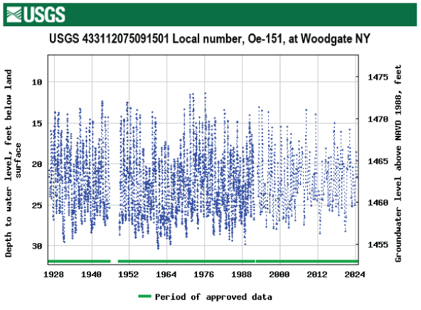
Groundwater levels in the Oneida County, New York, well (USGS station 433112075091501), recorded since 1926. Credit: U.S. Geological Survey.
Why these wells
Most observation wells are clustered where aquifers are heavily used. CRN wells are deliberately placed away from water-supply pumping, irrigation and other human activity, so they reflect the natural effects of climate variability, including droughts. They tap unconfined or near-surface confined aquifers, and each must:
- be open to a single, known hydrogeologic unit;
- have known construction;
- be accessible for the long term;
- be unlikely to go dry.
The network answers two questions: what condition are the nation's groundwater levels in, and how is climate affecting them? Its data underpin assessments and models linking climate to groundwater levels.
The network over time
| Federally funded CRN wells | |
|---|---|
| 2006 | About 140 |
| Peak, 2021–23 | 256 sites, covering nearly 70% of the nation's climate divisions |
| 2024 | 186 wells, in about 51% of climate divisions |
The goal is at least one monitored site in each of the 366 climate divisions of the United States, Puerto Rico and the U.S. Virgin Islands. The network is part of USGS's National Water Monitoring Network, and draws on the more than 2,000 sites where USGS measures water levels in real time.
- Federally funded sites, authorized by the SECURE Water Act of 2009 through the USGS Groundwater and Streamflow Information Program, measure water levels every 15 to 60 minutes and send data to USGS databases, viewable on Water Data for the Nation.
- Supplemental sites — more than 400, mostly in the eastern U.S., run with state, local, regional, tribal and other federal partners — are measured anywhere from monthly or quarterly by hand to continuously; more than 300 report in real time.
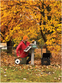
A USGS hydrologic technician measures the groundwater level at a Climate Response Network well in Worcester County, Massachusetts, October 2022. Credit: Samuel Banas, U.S. Geological Survey.
Long records matter
Judging trends — from climate or from aquifer development — takes years or decades of data. The federally funded CRN sites average more than 37 years of records, and 53 of the 186 have more than 50 years.
Sources
Based on "U.S. Geological Survey National Groundwater Climate Response Network," U.S. Geological Survey Fact Sheet 2024–3057; a work of the United States government in the public domain. Data are on the USGS Groundwater Climate Response Network websites and Water Data for the Nation.
Licença: CC0 1.0 (domínio público) · Adaptado de pubs.usgs.gov
1
0
0
0

Comentários


