Есть что улучшить? Предложите правку.

Download Image Download Image of the Low-pressure System
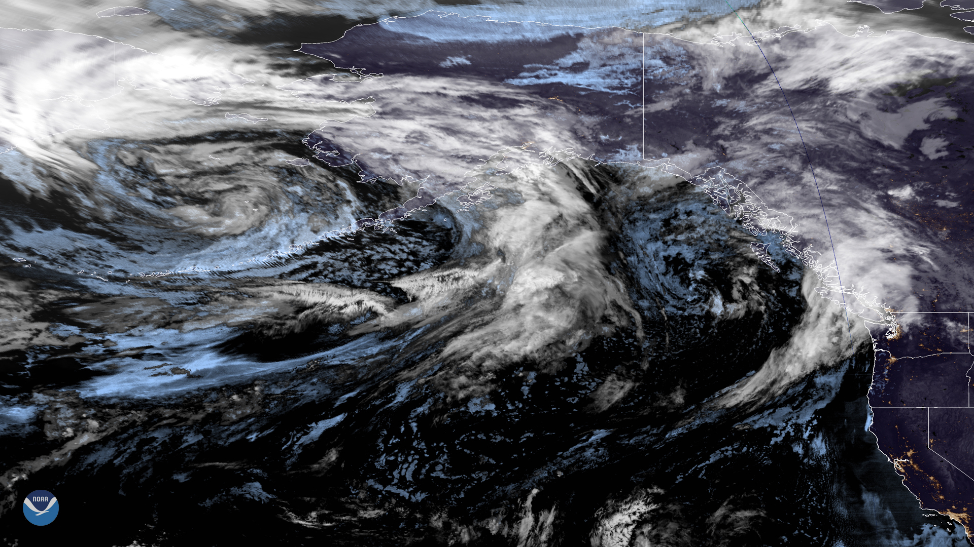
A large low-pressure system over the northern Pacific is making its way to the West Coast in this merged imagery captured by NOAAââ¬â¢s GOES East and West satellites at 8 a.m. EDT on Sept. 12, 2019. The system brought scattered and showers to the southeastern Gulf of Alaska Wednesday and into Thursday. As it pushes eastward, it will force northern Washington to say goodbye drier weather by this afternoon. The latest update from the National Weather Service (NWS) in Seattle shows rain arriving around 8 p.m. PDT.
Meanwhile, the extratropical remnants of Typhoons Lingling and Faxai ââ¬â both of which tore through eastern Asia earlier this week ââ¬â are already bringing strong winds and moderate rain to Kodiak Island and south-central Alaska, according to the NWS in Anchorage. During the last 24 hours, locations on Kodiak Island have received 0.44 to 1.28 inches of rain, while the Kenai Peninsula and southwest Alaska have picked up as much as 0.72 and 1.89 inches respectively. These showers are expected to continue through Friday morning. While Anchorage is only likely to see scattered showers, the NWS notes that more rain has fallen in the region during the first 10 days of September than the prior three months combined. Interior Alaska and the Kenai Peninsula have been plagued with intense wildfires throughout the summer months, so rain is certainly a welcome change that could help put a damper on wildfire activity in the region.
This GeoColor enhanced imagery was created by NOAA's partners at the Cooperative Institute for Research in the Atmosphere. The GOES East geostationary satellite, also known as GOES-16, provides coverage of the Western Hemisphere, including the United States, the Atlantic Ocean and the eastern Pacific. The satellite's high-resolution imagery provides optimal viewing of severe weather events, including thunderstorms, tropical storms, and hurricanes. The GOES West satellite, also known as GOES-17, provides geostationary satellite coverage of the Western Hemisphere, including the United States, the Pacific Ocean, Alaska and Hawaii. First launched in March 2018, the satellite became fully operational in February 2019.
Where this page came from
This page was imported from NOAA Satellites (NESDIS). Published by NOAA's National Environmental Satellite, Data, and Information Service and, as a work of the United States government, in the public domain; pictures credited elsewhere are left out.
Nobody has written it yet — it is the source material at a new address, which is why search engines are asked to skip it and why no one earns from it. It is up for grabs: take it on, and it is yours to rewrite and to earn from.
Лицензия: CC0 1.0 (общественное достояние) · По материалам www.nesdis.noaa.gov
1
0
0
0

Комментарии