

Vegetation Mapping Crew Lead Matt Lee documents a subalpine meadow and records data used to develop the North Cascades National Park vegetation map. NPS
Starting in 2005, the North Coast and Cascades Network (NCCN) embarked on the very large task of classifying, describing, and mapping the vegetation communities in three large, mountainous national parks: Mount Rainier, North Cascades, and Olympic National Parks. These three parks encompass an area over 741,436 hectares (1,832,487 acres), and with elevations ranging from sea level (Olympic) up 14,410 feet (Mount Rainier), vegetation communities are quite varied. In partnership with the Institute for Natural Resources (based at Portland State University), we have now completed this project, just over 15 years in the making! The project is also part of the larger National Park Service Vegetation Mapping Inventory, which is an effort to map the vegetation in over 270 park units across the United States.
Why map vegetation?
Maps provide valuable information about the distribution, extent, and patterns of the vegetation communities found in the parks and contribute useful data to a variety of projects including wildlife monitoring, tracking the impacts of climate change in unique habitats, and predicting the effects of wildland fire. They also serve as the baseline of vegetation information, allowing evaluating change in national park resources and ecosystems over time as well as making comparisons with unprotected areas.
How we did it
The mapping project started with visiting thousands of locations within the parks covering all elevations, zones, and landscapes. At each plot location, field crews made careful lists of the presence and cover of plant species that make up the plant community and recorded information about the surrounding environment.

Vegetation map for Mount Rainier National Park. NPS
The plant community descriptions were organized into map classes defined by the dominant canopy vegetation combined with identifying understory species, site moisture, or elevation characteristics. The same core map classes were used for all three parks, although each park features a few unique classes that reflect its unique geographic setting and history.

Vegetation map for North Cascades National Park. NPS
Because the parks are so large, the maps were made using state-of-the-art computer modeling techniques. To make the maps, first data were created from satellite images capturing features of the land surface most likely to influence vegetation patterns, such as elevation, topography, and climate. Next, the relationship between the satellite data and the plot data was generated for each of the thousands of plot points. These predictive relationships were then applied across the entire park.
The availability of detailed satellite data allowed the vegetation communities to be mapped at a very fine scale. Each unique map pixel is a 3x3 meter square. A minimum of 9 pixels were combined to make patches, and additional filtering was applied to smooth the appearance of the maps. The resulting patches in the maps are approximately 400 square meters (about a tenth of an acre).
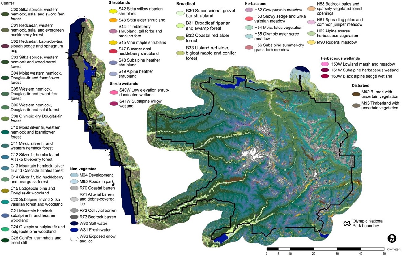
Vegetation map for Olympic National Park. NPS
The accuracy of the NCCN mapping approach was evaluated for each park using additional field data collected specifically for the assessment. For each field point, the plant community observed on the ground was compared to the modeled map class. The overall accuracy of each map exceeds the program standard of 80% (we did not evaluate the accuracy of the mapped areas outside the parks’ boundaries).
The new NCCN vegetation maps are already being put to use evaluating marmot habitat at Olympic National Park and helping refine maps of whitebark pine at Mount Rainier and North Cascades National Parks.
Where can you get the maps, reports, and data?
Where this belongs
- Mount Rainier National Park
- North Cascades National Park
- Olympic National Park
Where this page came from
This page was imported from National Park Service. Produced by the U.S. National Park Service and, as a work of the United States government, in the public domain.
Nobody has written it yet — it is the source material at a new address, which is why search engines are asked to skip it and why no one earns from it. It is up for grabs: take it on, and it is yours to rewrite and to earn from.
В подборкахMount Rainier National ParkNorth Cascades National ParkOlympic National Park
Лицензия: CC0 1.0 (общественное достояние) · По материалам www.nps.gov
1
0
0
0

Комментарии
Читать дальше


