
On This Page Navigation
Geodiversity refers to the full variety of natural geologic (rocks, minerals, sediments, fossils, landforms, and physical processes) and soil resources and processes that occur in the park. A product of the Geologic Resources Inventory, the NPS Geodiversity Atlas delivers information in support of education, Geoconservation, and integrated management of living (biotic) and non-living (abiotic) components of the ecosystem.

In-depth geologic information is contained in the baseline inventory products of the Geologic Resources Inventory, see table below.
Introduction
Catoctin Mountain Park (CATO) comprises the easternmost ridge of the Blue Ridge Mountains located about 89 km (55 mi) northwest of Washington, D.C. in Frederick County, Maryland. Originally established as Catoctin Recreation Demonstration Area on January 7, 1935, the park unit was renamed and redesignated on July 12, 1954 (National Park Service 2016a). Catoctin Mountain Park encompasses approximately 2,384 hectares (5,891 acres) and provides quality recreational opportunities in the Catoctin Mountains and serves as a setting and buffer for the presidential retreat site Camp David. The park represents an outstanding example of President Franklin D. Roosevelt’s New Deal-era legislation, and protects hardwood forest, historic buildings, camps, and pristine waterways while offering panoramic vistas of the Monocacy Valley. CATO is part of a larger protected area that includes Cunningham Falls State Park, the Frederick and Thurmont watersheds, and Gambrill State Park (Thornberry-Ehrlich 2009a).
Geologic Setting
Located on the easternmost portion of the Blue Ridge physiographic province of Maryland and northern Virginia, the landscape of CATO consists of rolling hills and narrow ridgetops separated by steep-sloped valleys and ravines (Thornberry-Ehrlich 2009a). The park is situated on the eastern slopes of Catoctin Mountain, which forms the eastern limb of the larger Blue Ridge–South Mountain anticlinorium. The bedrock underlying CATO is predominantly composed of metabasalt and metarhyolite of the Neoproterozoic Catoctin Formation. Meta-igneous rocks of the Catoctin Formation are interpreted as the remnants of continental flood basalts that erupted at a time when North America rifted apart to form the Iapetus Ocean (Mitra 1989; Badger 1992). Younger, Cambrian-age metamorphic units are mapped in the southeastern portion of CATO and include rocks of the Chilhowee Group (Loudoun, Weverton, and Harpers Formations). CATO and the surrounding area provides an opportunity to observe regional-scale deformation and metamorphism resulting from three major tectonic events (Taconic, Acadian, and Alleghenian Orogenies) that constructed the Appalachian Mountains.
Abandoned Mineral Lands
NPS AML sites can be important cultural resources and habitat, but many pose risks to park visitors and wildlife, and degrade water quality, park landscapes, and physical and biological resources. Be safe near AML sites—Stay Out and Stay Alive!
Regional Geology
Catoctin Mountain Park is a part of the Blue Ridge Physiographic Province and shares its geologic history and some characteristic geologic formations with a region that extends well beyond park boundaries.
Maps and Reports
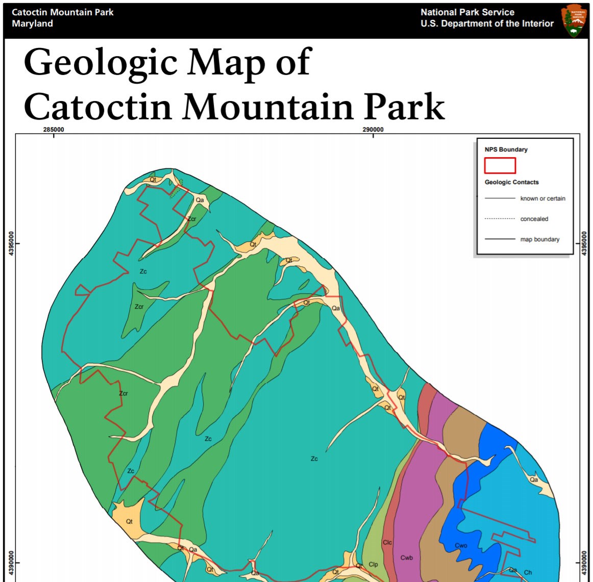
Geologic Resources Inventory
The Geologic Resources Inventory produces digital geologic maps and reports for more than 270 natural resource parks. The products listed below are currently available for this park, check back often for updates as many maps, reports, and posters are still in progress.
Scoping summaries are records of scoping meetings where NPS staff and local geologists determined the park’s geologic mapping plan and what content should be included in the report.
- Digital geologic maps include files for viewing in GIS software, a guide to using the data, and a document with ancillary map information. Newer products also include data viewable in Google Earth and online map services.
- Reports use the maps to discuss the park’s setting and significance, notable geologic features and processes, geologic resource management issues, and geologic history.
- Posters are a static view of the GIS data in PDF format. Newer posters include aerial imagery or shaded relief and other park information. They are also included with the reports.
- Projects list basic information about the program and all products available for a park.
Source: NPS DataStore Saved Search 2803. To search for additional information, visit the NPS DataStore.
Soil Resources inventory
A NPS Soil Resources Inventory project has been completed for Catoctin Mountain Park and can be found on the NPS Data Store.
Source: NPS DataStore Saved Search 2754. To search for additional information, visit the NPS DataStore.
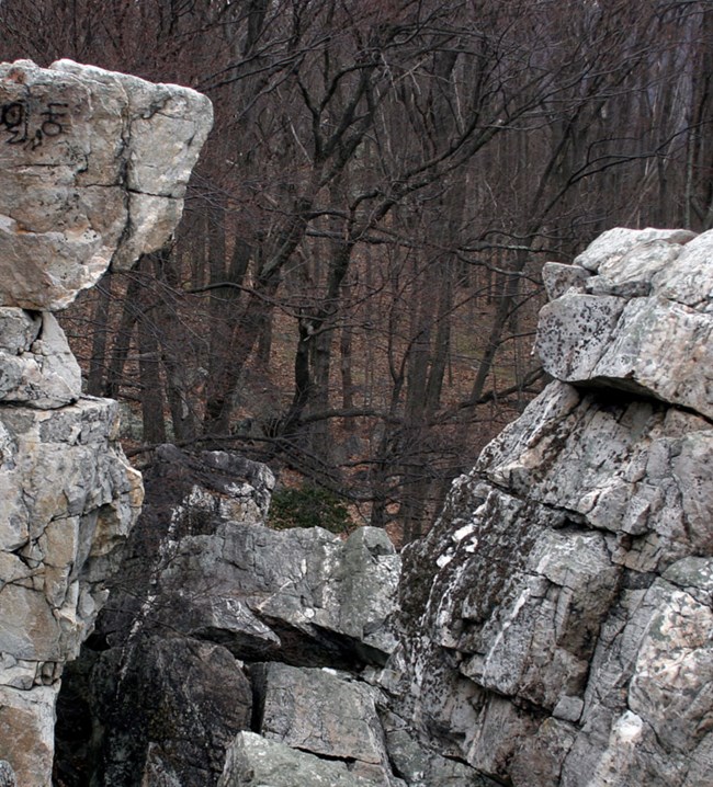
Wolf Rock is made up of metamorphosed fluvial (river deposited) sediments of the Weverton Formation (Maryland Heights Member) in Catoctin Mountain Park. (NPS Photo by Gregory Gusse)
Related Links
Catoctin Mountain Park—Geology
Catoctin Mountain Park—Mountains
Catoctin Mountain Park—Catoctin Iron Furnace
Catoctin Mountain Park—Photo Gallery: Catoctin Mountain Park Scenery
Catoctin Mountain Park—Park Home
Catoctin Mountain Park
Narrow By Location
Narrow By Office
Show
10
40
Sort by
Relevance
Recently Updated
Date Released
Title
Loading results...
Tags:
geodiversity
,
geologic
,
[geologic forces](/media/article-search.htm?q=geologic forces)
,
[geologic resources](/media/article-search.htm?q=geologic resources)
,
[geologic feature](/media/article-search.htm?q=geologic feature)
,
[geologic time](/media/article-search.htm?q=geologic time)
,
[geologic layers](/media/article-search.htm?q=geologic layers)
,
[geologic history](/media/article-search.htm?q=geologic history)
,
[geologic formations](/media/article-search.htm?q=geologic formations)
,
geology
,
geological
,
[geological maps](/media/article-search.htm?q=geological maps)
,
geologist
,
[geology talk](/media/article-search.htm?q=geology talk)
,
[geology hike](/media/article-search.htm?q=geology hike)
,
[geology science and learning](/media/article-search.htm?q=geology science and learning)
,
geologists
,
[geology close up](/media/article-search.htm?q=geology close up)
,
[geologic resources inventory](/media/article-search.htm?q=geologic resources inventory)
,
geoheritage
,
geohazards
,
geomorphology
,
[geoscientists in parks](/media/article-search.htm?q=Geoscientists in Parks)
,
geoscientists-in-the-parks
,
[geological survey](/media/article-search.htm?q=Geological Survey)
,
geothermal
,
[geothermal activity](/media/article-search.htm?q=geothermal activity)
,
geotour
,
geotourism
,
[geothermal processes & features](/media/article-search.htm?q=geothermal processes & features)
,
fossils
,
paleontology
,
caves
,
karst
,
glaciers
,
[geoheritage sites](/media/article-search.htm?q=geoheritage sites)
,
earthquakes
,
landslides
,
mining
National Park Service Geodiversity Atlas
The servicewide Geodiversity Atlas provides information on geoheritage and geodiversity resources and values within the National Park System. This information supports science-based geoconservation and interpretation in the NPS, as well as STEM education in schools, museums, and field camps. The NPS Geologic Resources Division and many parks work with National and International geoconservation communities to ensure that NPS abiotic resources are managed using the highest standards and best practices available.
Where this belongs
- Catoctin Mountain Park
Where this page came from
This page was imported from National Park Service. Produced by the U.S. National Park Service and, as a work of the United States government, in the public domain.
Nobody has written it yet — it is the source material at a new address, which is why search engines are asked to skip it and why no one earns from it. It is up for grabs: take it on, and it is yours to rewrite and to earn from.
В подборкахCatoctin Mountain Park
Лицензия: CC0 1.0 (общественное достояние) · По материалам www.nps.gov
1
0
0
0

Комментарии
Читать дальше


