
On This Page Navigation
Geodiversity refers to the full variety of natural geologic (rocks, minerals, sediments, fossils, landforms, and physical processes) and soil resources and processes that occur in the park. A product of the Geologic Resources Inventory, the NPS Geodiversity Atlas delivers information in support of education, Geoconservation, and integrated management of living (biotic) and non-living (abiotic) components of the ecosystem.

In-depth geologic information is contained in the baseline inventory products of the Geologic Resources Inventory, see table below.
Introduction
Point Reyes National Seashore is located on Point Reyes Peninsula near the San Francisco Bay metropolitan area in Marin County, California. Authorized on September 13, 1962, Point Reyes preserves approximately 28,755 hectares (71,055 acres) of geologically unique peninsular terrane that includes beaches, lagoons, coastal cliffs and headlands, marine terraces, coastal uplands, open grasslands, brushy hillsides, forested ridges, and all tidal and submerged lands up to 0.4 km (0.25 mi) offshore. Point Reyes contains more than 129 km (80 mi) of undeveloped coastline, 237 km (147 mi) of hiking trails, backcountry campgrounds, and many scenic beaches. Point Reyes supports a diverse assemblage of biota, including more than 900 plant species, more than 490 avian species, and at least 28 threatened and endangered species. More than 120 archeological sites in Point Reyes document an extensive 5,000-year human occupation and provide insight into the long history of the Coast Miwok people in the Bay Area. Point Reyes contains about 400 historic structures including the historic Point Reyes Lighthouse built in 1870 and two national historic landmarks: the Point Reyes Lifeboat Station and the Drakes Bay Historic and Archaeological District.
Geologic Setting
The geology of Point Reyes National Seashore provides an exceptional opportunity to study plate tectonics, allowing geologists to reconstruct portions of Earth history along strike of the San Andreas Fault. Geologic units in Point Reyes can be broken down into three main groups of rock: (1) Paleozoic and/or Mesozoic metamorphic rocks that occur along Inverness Ridge; (2) Cretaceous-age intrusive rocks; and (3) Cenozoic sedimentary deposits. Plutonic igneous rocks form the Point Reyes Headlands and portions of Inverness Ridge, and include several informal units including the granodiorite of Inverness Ridge, granodiorite of Point Reyes, and tonalite of Tomales Point. These intrusive rocks originated from a massive batholith in southern California and were subsequently displaced by lateral fault motion to their current location. Cenozoic-age units are widely mapped across Point Reyes and include marine sedimentary rocks of the Eocene Point Reyes Conglomerate; Miocene Laird Sandstone, Monterey Formation, Santa Cruz Mudstone, and Santa Margarita Formation; Miocene–Pliocene Purisima Formation; and Pliocene–Pleistocene Merced Formation. Young surficial deposits mapped within Point Reyes include Quaternary-age landslide deposits, alluvium, marine terrace deposits, dune sand, beach sand, and bay mud. The landscape of Point Reyes contains valleys, ridges, rolling grasslands, sandy beaches, and rocky promontories whose physiography is largely controlled by the underlying Point Reyes syncline.
Regional Geology
Point Reyes National Seashore is a part of the Pacific Border Physiographic Province and shares its geologic history and some characteristic geologic formations with a region that extends well beyond park boundaries.
Maps and Reports

.
Geologic Resources Inventory
The Geologic Resources Inventory produces digital geologic maps and reports for more than 270 natural resource parks. The products listed below are currently available for this park, check back often for updates as many maps, reports, and posters are still in progress.
Scoping summaries are records of scoping meetings where NPS staff and local geologists determined the park’s geologic mapping plan and what content should be included in the report.
- Digital geologic maps include files for viewing in GIS software, a guide to using the data, and a document with ancillary map information. Newer products also include data viewable in Google Earth and online map services.
- Reports use the maps to discuss the park’s setting and significance, notable geologic features and processes, geologic resource management issues, and geologic history.
- Posters are a static view of the GIS data in PDF format. Newer posters include aerial imagery or shaded relief and other park information. They are also included with the reports.
- Projects list basic information about the program and all products available for a park.
Source: NPS DataStore Saved Search 3149. To search for additional information, visit the NPS DataStore.
Soil Resources inventory
A NPS Soil Resources Inventory project has been completed for Point Reyes National Seashore and can be found on the NPS Data Store.
Source: NPS DataStore Saved Search 3100. To search for additional information, visit the NPS DataStore.
GRI Geology Image Gallery
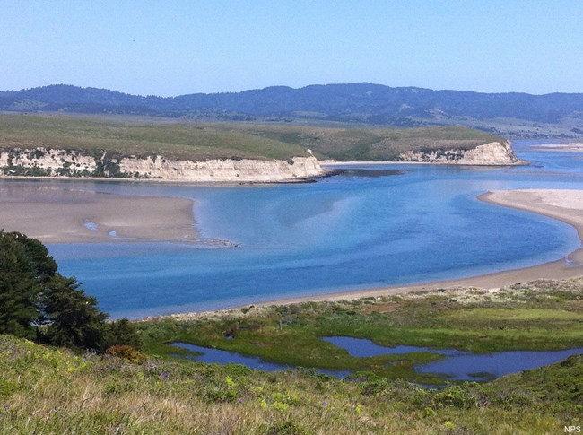
Drakes Harbor.
Related Links
Point Reyes—Natural Features and Ecosystems
NPS—Beaches and Coastal Landforms
NPS—Plate Tectonics & Our National Parks—Transform Plate Boundaries
Related Articles
Point Reyes National Seashore
Narrow By Location
Narrow By Office
Show
10
40
Sort by
Relevance
Recently Updated
Date Released
Title
Loading results...
Tags:
geodiversity
,
geologic
,
[geologic forces](/media/article-search.htm?q=geologic forces)
,
[geologic resources](/media/article-search.htm?q=geologic resources)
,
[geologic feature](/media/article-search.htm?q=geologic feature)
,
[geologic time](/media/article-search.htm?q=geologic time)
,
[geologic layers](/media/article-search.htm?q=geologic layers)
,
[geologic history](/media/article-search.htm?q=geologic history)
,
[geologic formations](/media/article-search.htm?q=geologic formations)
,
geology
,
geological
,
[geological maps](/media/article-search.htm?q=geological maps)
,
geologist
,
[geology talk](/media/article-search.htm?q=geology talk)
,
[geology hike](/media/article-search.htm?q=geology hike)
,
[geology science and learning](/media/article-search.htm?q=geology science and learning)
,
geologists
,
[geology close up](/media/article-search.htm?q=geology close up)
,
[geologic resources inventory](/media/article-search.htm?q=geologic resources inventory)
,
geoheritage
,
geohazards
,
geomorphology
,
[geoscientists in parks](/media/article-search.htm?q=Geoscientists in Parks)
,
geoscientists-in-the-parks
,
[geological survey](/media/article-search.htm?q=Geological Survey)
,
geothermal
,
[geothermal activity](/media/article-search.htm?q=geothermal activity)
,
geotour
,
geotourism
,
[geothermal processes & features](/media/article-search.htm?q=geothermal processes & features)
,
fossils
,
paleontology
,
caves
,
karst
,
glaciers
,
[geoheritage sites](/media/article-search.htm?q=geoheritage sites)
,
earthquakes
,
landslides
,
mining
National Park Service Geodiversity Atlas
The servicewide Geodiversity Atlas provides information on geoheritage and geodiversity resources and values within the National Park System. This information supports science-based geoconservation and interpretation in the NPS, as well as STEM education in schools, museums, and field camps. The NPS Geologic Resources Division and many parks work with National and International geoconservation communities to ensure that NPS abiotic resources are managed using the highest standards and best practices available.
Where this belongs
- Point Reyes National Seashore
Where this page came from
This page was imported from National Park Service. Produced by the U.S. National Park Service and, as a work of the United States government, in the public domain.
Nobody has written it yet — it is the source material at a new address, which is why search engines are asked to skip it and why no one earns from it. It is up for grabs: take it on, and it is yours to rewrite and to earn from.
В подборкахPoint Reyes National Seashore
Лицензия: CC0 1.0 (общественное достояние) · По материалам www.nps.gov
1
0
0
0

Комментарии
Читать дальше


