
Есть что улучшить? Предложите правку.
By Stanley C. Skrobialowski, W. Reed Green, and Joel M. Galloway
Water-quality samples collected from drainage canals, from Lake Pontchartrain, La., and from flood waters contained contaminants typically found in waters influenced by urban runoff. Pesticides and wastewater compounds were detected in all water samples, but none exceeded U.S. Environmental Protection Agency (EPA) drinking water or aquatic life criteria. Although metals were detected in all samples, copper, nickel, and silver occurred in concentrations greater than water-quality criteria for salt water. Salinity levels in the freshwater marshes south of New Orleans were typical of Gulf of Mexico waters for an extended period of time, and levels did not return to prehurricane levels until February 2006.
Introduction
Water samples were collected after Katrina and Rita to better understand and document the transport of nutrients, metals, pesticides, and other contaminants from the flooded areas in parts of New Orleans, La., to Lake Pontchartrain, La., and subsequently, samples from nine sites in or near Lake Pontchartrain and three outlets to the Gulf of Mexico between September 22 and October 19, 2005 (fig. 1). Thirty samples were collected from 12 sites over a 4-week period. Nine of the 12 sites were of Mexico. Typically,
Geological Survey (USGS) Arkansas and Louisiana Water Science Centers collected water to the Gulf
low dissolved-oxygen (DO)
concentrations and saltwater intrusion are the water-quality issues associated with large coastal storms. Fish kills can result
were pumped or released to Lake Pontchartrain and the Gulf of Mexico. In response to the flooding in parts of New Orleans, staff from the U.S. from low DO concentrations caused by suspension of anaerobic sediments resulting in immediate oxygen demand and the associated release
businesses, and industries and carried corpses. Additional concerns included the quality, fate, and transport of these flood waters that of hydrogen sulfide. Flood waters from Katrina and Rita inundated cars, sewage-treatment plants, homes,

Figure 1. Water-quality sites in and near Lake Pontchartrain, La., after Hurricanes Katrina and Rita, 2005.
sampled two to three times during the sampling period. Water samples were analyzed for various constituents including 6 nutrients, 22 metals, 189 pesticides and wastewater compounds, and 86 volatile organic compounds (VOCs). Water and air temperature, DO, specific conductance, and pH also were measured (Baumann and others, 2006).
The flood waters pumped from New Orleans and delivered to Lake Pontchartrain contained a mixture of nutrients, metals, and organic compounds typical of urban streams. Copper, nickel, and silver were the only contaminants detected in concentrations exceeding criteria for the protection of aquatic life in salt water established by the U.S. Environmental Protection Agency (2002). Isolated fish kills reported by some residents were probably associated with low DO concentrations but were not extensive throughout the lake. The storm surge associated with Rita delivered substantially saltier water to areas south of New Orleans—the full effects of which have yet to be determined.
Nutrients, primarily forms of nitrogen and phosphorus found in lawn fertilizer and sewage, have been associated with harmful algal blooms, oxygen depletion, and subsequent fish kills. Nutrient concentrations were greatest in floodwater samples collected from Jahncke Canal and a flooded street in the Lower Ninth Ward (fig. 1) in New Orleans. Unlike the water from other lake and outlet sites, water at these sites had not been diluted with lake or gulf waters. These sites were sampled only once about 2 weeks after Rita made landfall. The warm sunny weather that occurred a few weeks after Rita facilitated evaporation and may have increased total nitrogen and phosphorus concentrations in water at these sites.
Many VOCs are known or suspected to cause cancer and originate as solvents and petroleum compounds. Few VOCs were detected in flood waters, in part because of (1) the reaeration of canal water (fig. 2) by the U.S. Army Corps of Engineers prior to pumping the water into the lake to prevent low DO problems and (2) the many clear, sunny days after the
Water Quality of Lake Pontchartrain and Outlets to the Gulf of Mexico Following Hurricanes Katrina and Rita
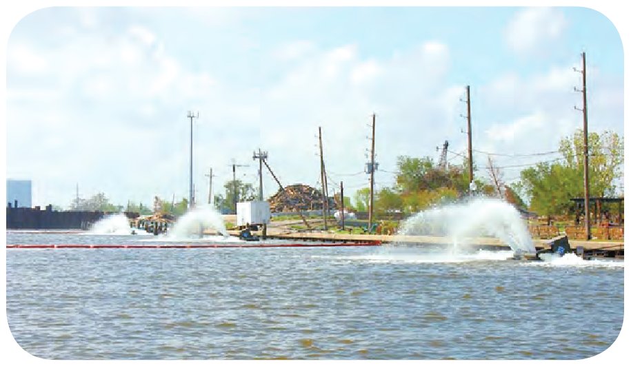
storms that may have volatized or photodegraded these compounds. Of the 86 VOCs for which samples were analyzed, 16 were detected in quantifiable concentrations; a total of 50 VOC detections occurred in 29 samples. Chloroform, toluene, and carbon disulfide accounted for 26 of the 50 detected VOC concentrations. Detected concentrations occurred at all sites except Chef Menteur Pass, and 29 concentrations of 17 VOCs were detected in three samples from the Metaire Outfall Canal (popularly known as the 17th Street Canal).
Pesticides and wastewater compounds were detected in all water samples, but none exceeded EPA drinking water or aquatic life criteria. Of the 189 pesticides and wastewater compounds for which samples were analyzed, caffeine (an urban tracer), tris(2-chloroethyl)phosphate (a flame retardant), and atrazine (an herbicide) were detected in all water samples. Insecticides such as fipronil, metolachlor, and prometon also were detected in almost all of the samples. The greatest number of pesticides and wastewater compounds detected (28) were from the flooded street sample collected from the Lower Ninth Ward. More than 20 pesticides and wastewater compounds were detected in each of the samples from the 17th Street Canal. In general, for sites where multiple samples were collected, the number of detections in the first sample was greater than the number of detections in the last sample.

Figure 2. Aerators on the Metairie Outfall Canal (popularly known as the 17th Street Canal) near Metairie, La., September 29, 2005.
Metals were detected in samples from each site, but copper, nickel, and silver were the only contaminants detected in concentrations exceeding criteria for the protection of aquatic life in salt water established by the EPA. Copper was detected in samples collected from all sites except for the flooded street sample collected in the Lower Ninth Ward (fig. 3); concentrations exceeded the criterion continuous concentration (CCC), 3.1 μg/L, for salt water (U.S. Environmental Protection Agency, 2002) in 26 of the 28 samples for which copper was analyzed. Concentrations above the CCC may result in adverse effects on aquatic communities. The greatest copper concentration, 18.3 μg/L, was detected in a sample collected from the Gulf Intracoastal Waterway. The CCC for nickel in salt water (8.2 μg/L) was exceeded in samples collected from Jahncke Canal (18.9 μg/L), Bayou St. John (11.2 μg/L), and the Gulf Intracoastal Waterway (11.6 μg/L). Silver concentrations in samples collected from Chef Menteur Pass and the Gulf Intracoastal Waterway exceeded the criteria maximum concentration (CMC), 1.9 μg/L. The CMC is an estimate of the greatest concentration to which an aquatic community can be exposed briefly without resulting in an unacceptable effect (U.S. Environmental Protection Agency, 2002). Arsenic, beryllium, boron, chromium, cobalt, copper, lithium, manganese, molybdenum, nickel, selenium, strontium, vanadium, and zinc were detected in at least one sample from each site, and aluminum, antimony, lead, iron, and silver were detected in samples from about half of the sites.
The storm surges associated with Katrina and Rita were monitored not only with water-level (gage height) sensors but also with water-quality sensors. Salinity for both hurricanes was recorded by a continuous water-quality monitor south of New Orleans, at Lake Cataouatche at Whiskey Canal south of Waggaman, La. A slight decrease in salinity was recorded on August 29 as fresher water was drawn south by the prevailing north winds of Katrina. Conversely, a rapid increase in salinity was recorded as waters from the Gulf of Mexico were driven north by the prevailing south winds of Rita (fig. 4). Salinity at the Lake Cataouatche site was less than 0.3 parts per thousand (ppt) before Rita and peaked at about 3.7 ppt in November and December 2005. Because little or no rainfall occurred for several months after the hurricanes, salinities did not return to prehurricane levels, about 0.2 ppt, until February 2006. The marsh in and around the lake is dominated by freshwater plants, and the full effect of the salt water on these plants is not currently known.

Figure 4. Gage height and salinity at Lake Cataouatche at Whiskey Canal south of Waggaman, La., August 28, 2005, to February 28, 2006.
Conclusion
Katrina and Rita devastated the Gulf Coast of Louisiana and Mississippi in late August and September 2005. Of major concern was the impact that storm surges and flood waters had on the water quality of Lake Pontchartrain. The storm surges delivered saline water to the brackish lake, and flood waters from New Orleans were pumped into the lake at various locations along the southern shore. Water-quality samples collected from the drainage canals, Lake Pontchartrain, and the flood waters contained contaminants (elevated nutrients, metals, and organics) typically found in waters influenced by urban runoff. Typically, the number of contaminants detected in water samples and concentrations were highest in the first samples collected after the hurricanes passed and became fewer at lower concentrations as time passed. A continuously recording water-quality monitor located in Lake Cataouatche, south of New Orleans, measured salinity levels more typical of gulf waters for an extended period of time, and levels did not return to prehurricane levels until February 2006. Overall, the water quality of Lake Pontchartrain and its outlets to the Gulf of Mexico was affected by events resulting from Katrina and Rita. Except for copper, nickel, and silver, however, no contaminant concentrations in water samples exceeded the criteria established by EPA for the protection of aquatic life in salt water.
References
Baumann, T.E., Goree, B.B., Lovelace, W.M., Montgomery, P.A., Ross, G.B., Walters, D.J., and Ward, A.N., 2006, Water resources data for Louisiana, water year 2005: U.S. Geological Survey Water-Data Report LA-05-01, 909 p.
U.S. Environmental Protection Agency, 2002, National recommended water quality criteria—2002: Washington, D.C., U.S. Environmental Protection Agency, Office of Science and Technology, Office of Water (4304T) EPA 822- R-02-047, 33 p.
Where this page came from
This page was imported from U.S. Geological Survey. Published by the U.S. Geological Survey and, as a work of the United States government, in the public domain.
Nobody has written it yet — it is the source material at a new address, which is why search engines are asked to skip it and why no one earns from it. It is up for grabs: take it on, and it is yours to rewrite and to earn from.
Лицензия: CC0 1.0 (общественное достояние) · По материалам pubs.usgs.gov
1
0
0
0

Комментарии


