
Vill du förbättra sidans innehåll? Föreslå en ändring.
On This Page Navigation
Geodiversity refers to the full variety of natural geologic (rocks, minerals, sediments, fossils, landforms, and physical processes) and soil resources and processes that occur in the park. A product of the Geologic Resources Inventory, the NPS Geodiversity Atlas delivers information in support of education, Geoconservation, and integrated management of living (biotic) and non-living (abiotic) components of the ecosystem.

In-depth geologic information is contained in the baseline inventory products of the Geologic Resources Inventory, see table below.
Geologic Features and Processes
Dinosaur National Monument was established in 1915 to protect and preserve the immense paleontological resources at the Dinosaur Quarry made famous by Earl Douglass and W. J. Holland. The Dinosaur Quarry has three layers of fossil bones with the first layer primarily excavated in the early 1900's for museums. The second layer of bones has been uncovered and prepared to preserve the fossils in situ for visitors. The third layer remains less developed as the others (Graham 2006). The Monument contains one of the greatest Jurassic fossil quarry localities in the world with over 1,500 dinosaur bones exposed.
Dinosaur National Monument is located on the eastern end of the Uinta Mountains, a broad anticline (upwarped geologic structure) formed during the Laramide Orogeny (about 70-40 Ma) (Graham 2006). Laramide-age structures of faults and folds are exposed throughout the monument and are considered some of the best exposures found anywhere within the Rocky Mountains (Gregson and Chure 2000).
Differential erosion of the geologic layers ranging from Precambrian to Recent results in a spectacular display of colors and landforms throughout the monument. Additionally, the Green and Yampa rivers have carved out numerous unique canyons within the monument, which include the Canyon of Lodore, Yampa Canyon, Split Mountain Canyon, Whirlpool Canyon, and Jones Hole. The Canyon of Lodore and Yampa Canyon are recognized as two of the greatest river gorges of western North America (Graham 2006).
Paleontological Resources
The following formations are sources of paleontological resources at Dinosaur: Lodore Formation (Upper Cambrian), Madison Limestone (Lower-Middle Mississippian), Doughnut Shale (Middle-Upper Mississippian), Round Valley Formation (Lower Pennsylvanian), Morgan Formation (Middle Pennsylvanian), Weber Sandstone (Middle Pennsylvanian-Lower Permian), Park City Formation (Lower-Middle Permian), Chinle Formation (Upper Triassic), Nugget Sandstone (Upper Triassic-Lower Jurassic), Carmel Formation (Middle Jurassic), Stump Formation (Upper Jurassic), Morrison Formation (Upper Jurassic), Cedar Mountain Formation (Lower Cretaceous), Mowry Shale (Upper Cretaceous), Frontier Formation (Upper Cretaceous), and the Mancos Shale (Upper Cretaceous).
Fossils found at Dinosaur National Monument include foraminifera, petrified wood and plant remains, Charophytes, bryozoans, sponges, crinoids, ostracodes, trilobites, mollusks, vertebrates (fish, turtles, frogs, theropods, sauropods, ornithopods and mammals), and tracks. One of the best terrestrial fossil records from the Mesozoic, the Morrison Formation, contains numerous dinosaur remains such as Allosaurus, Apatosaurus, Diplodocus, Camarasaurus, and Stegosaurus in the Dinosaur Quarry.
All NPS fossil resources are protected under the Paleontological Resources Preservation Act of 2009 (Public Law 111-11, Title VI, Subtitle D; 16 U.S.C. §§ 470aaa - 470aaa-11).
Cave and Karst
Dinosaur National Monument contains at least five caves. There are 13 geologic units ranging from the Mississippian (259 million years ago) to the Upper Cretaceous (100 million years ago) that are limestone/carbonates and should exhibit karstic characteristics and processes. It is unknown whether these carbonate units contain karst aquifers, springs, or endemic karst invertebrates. Karst resources are found within 39.2% of the park unit. There are 14 species of bats though it is unclear if bats are using caves for habitat.
All NPS cave resources are protected under the the Federal Cave Resources Protection Act of 1988 (FCRPA)(16 U.S.C. § 4301 et seq.).
Abandoned Mineral Lands
NPS AML sites can be important cultural resources and habitat, but many pose risks to park visitors and wildlife, and degrade water quality, park landscapes, and physical and biological resources. Be safe near AML sites—Stay Out and Stay Alive!
Soils
As documented in the completed NPS Soil Resources Inventory for Dinosaur National Monument, 77 different soil map units occur in the park, with 80 different soils types. The high clay content and clay mineralogy of the Bodry, Deaver, Chipeta, Hanksville, and Massadona soils pose a potential soil hazard to buildings, roads, and other structures due to the high shrink-swell rating of these soils. See Soil Resources Inventory, below.
Regional Geology
Dinosaur National Monument is a part of the Colorado Plateaus Physiographic Province and shares its geologic history and some characteristic geologic formations with a region that extends well beyond park boundaries.
Maps and Reports
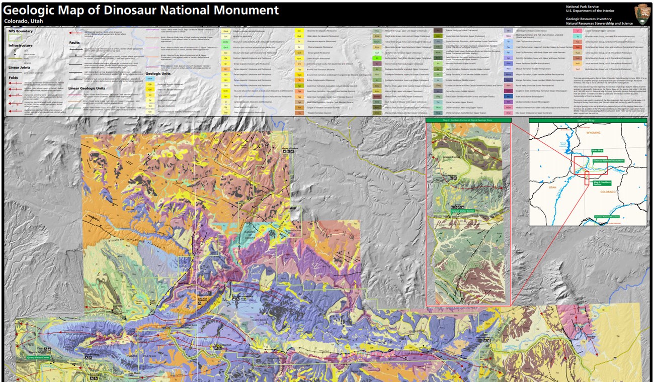
Geologic Resources Inventory
The Geologic Resources Inventory produces digital geologic maps and reports for more than 270 natural resource parks. The products listed below are currently available for this park, check back often for updates as many maps, reports, and posters are still in progress.
Scoping summaries are records of scoping meetings where NPS staff and local geologists determined the park’s geologic mapping plan and what content should be included in the report.
- Digital geologic maps include files for viewing in GIS software, a guide to using the data, and a document with ancillary map information. Newer products also include data viewable in Google Earth and online map services.
- Reports use the maps to discuss the park’s setting and significance, notable geologic features and processes, geologic resource management issues, and geologic history.
- Posters are a static view of the GIS data in PDF format. Newer posters include aerial imagery or shaded relief and other park information. They are also included with the reports.
- Projects list basic information about the program and all products available for a park.
Source: NPS DataStore Saved Search 2812. To search for additional information, visit the NPS DataStore.
Soil Resources inventory
A NPS Soil Resources Inventory project has been completed for Dinosaur National Monument and can be found on the NPS Data Store.
Source: NPS DataStore Saved Search 2827. To search for additional information, visit the NPS DataStore.

Green River, Dinosaur National Monument.
Related Links
Dinosaur—Superstars of Paleontology
Dinosaur—Biological Soil Crusts
Dinosaur National Monument
Narrow By Location
Narrow By Office
Show
10
40
Sort by
Relevance
Recently Updated
Date Released
Title
Loading results...
Tags:
geodiversity
,
geologic
,
[geologic forces](/media/article-search.htm?q=geologic forces)
,
[geologic resources](/media/article-search.htm?q=geologic resources)
,
[geologic feature](/media/article-search.htm?q=geologic feature)
,
[geologic time](/media/article-search.htm?q=geologic time)
,
[geologic layers](/media/article-search.htm?q=geologic layers)
,
[geologic history](/media/article-search.htm?q=geologic history)
,
[geologic formations](/media/article-search.htm?q=geologic formations)
,
geology
,
geological
,
[geological maps](/media/article-search.htm?q=geological maps)
,
geologist
,
[geology talk](/media/article-search.htm?q=geology talk)
,
[geology hike](/media/article-search.htm?q=geology hike)
,
[geology science and learning](/media/article-search.htm?q=geology science and learning)
,
geologists
,
[geology close up](/media/article-search.htm?q=geology close up)
,
[geologic resources inventory](/media/article-search.htm?q=geologic resources inventory)
,
geoheritage
,
geohazards
,
geomorphology
,
[geoscientists in parks](/media/article-search.htm?q=Geoscientists in Parks)
,
geoscientists-in-the-parks
,
[geological survey](/media/article-search.htm?q=Geological Survey)
,
geothermal
,
[geothermal activity](/media/article-search.htm?q=geothermal activity)
,
geotour
,
geotourism
,
[geothermal processes & features](/media/article-search.htm?q=geothermal processes & features)
,
fossils
,
paleontology
,
caves
,
karst
,
glaciers
,
mining
National Park Service Geodiversity Atlas
The servicewide Geodiversity Atlas provides information on geoheritage and geodiversity resources and values within the National Park System. This information supports science-based geoconservation and interpretation in the NPS, as well as STEM education in schools, museums, and field camps. The NPS Geologic Resources Division and many parks work with National and International geoconservation communities to ensure that NPS abiotic resources are managed using the highest standards and best practices available.
Where this belongs
- Dinosaur National Monument
Where this page came from
This page was imported from National Park Service. Produced by the U.S. National Park Service and, as a work of the United States government, in the public domain.
Nobody has written it yet — it is the source material at a new address, which is why search engines are asked to skip it and why no one earns from it. It is up for grabs: take it on, and it is yours to rewrite and to earn from.
I dessa samlingarDinosaur National Monument
Licens: CC0 1.0 (allmän egendom) · Bearbetat efter www.nps.gov
1
0
0
0

Kommentarer
Läs härnäst


