
Ser du något att förbättra? Föreslå en ändring.
Ohio is completely covered by lidar at quality level 2 or better. A federal
assessment put the value of having it at $8.28 million a year, and most of
that is agriculture.
What 3DEP is
The 3D Elevation Program is run by the U.S. Geological Survey with federal,
state, tribal, territorial and local partners, and its job is consistent lidar
coverage of the country. Lidar gives a three-dimensional model of the ground
and everything standing on it, accurate enough to tell a gutter from a kerb.
Quality is graded by vertical error and how densely the pulses fall:
| Quality level | Vertical RMSE | Pulse spacing | Pulse density |
|---|---|---|---|
| QL0 | ≤5 cm | ≤0.35 m | ≥8.0 /m² |
| QL1 | ≤10 cm | ≤0.35 m | ≥8.0 /m² |
| QL2 | ≤10 cm | ≤0.71 m | ≥2.0 /m² |
QL2 is the 3DEP baseline: 1-metre-or-better digital elevation models and the
point clouds behind them, meeting the
Lidar Base Specification. **Ohio is at
100% for QL1 and QL2.**
Where the $8.28 million comes from
The National Enhanced Elevation Assessment asked what users would do with the
data and costed it conservatively. Ohio's top nine uses:
| Business use | Annual benefit | |
|---|---|---|
| 1 | Agriculture and precision farming | $3.48M |
| 2 | Natural resources conservation | $1.90M |
| 3 | Flood risk management | $1.88M |
| 4 | Infrastructure and construction management | $0.31M |
| 5 | Water supply and quality | $0.15M |
| 6 | Coastal zone management | $0.15M |
| 7 | Aviation navigation and safety | $0.15M |
| 8 | Forest resources management | $0.12M |
| 9 | Geologic resource assessment and hazard mitigation | $0.08M |
| Everything else | $0.06M | |
| Total | $8.28M |
Three uses are 88% of the value, which is worth knowing before anyone
argues about the ninth.
Four of them, concretely
Water supply and quality. QL1 data is being used on runoff in the Lake
Erie watershed — non-point-source pollution of lakes, rivers and wetlands,
which has affected municipal water supplies, spoiled recreation and hurt
biological productivity in the region.
Infrastructure. Columbus bought QL0 coverage of its whole multi-county
service area for the Blueprint Columbus programme. It feeds the city's
hydraulic models: stormwater drainage, street-gutter flow paths that run the
wrong way, surface flooding and ponding, pollution loads.
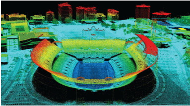
*Ohio Stadium from the lidar point cloud. Colour is height above ground — the
playing field dark blue, the upper deck orange, the tallest nearby buildings
red. Ohio Geographically Referenced Information Program.*
Natural resources. Ohio's Orphan Well Program has plugged over a thousand
abandoned oil and gas wells since 1977 — wells with no owner left to pay for
the work, leaking oil, gas and brine into soil and water. QL1 lidar is being
used to find the ones nobody has a record of.
Geology. Ohio's mineral industries produced almost $1.5 billion of
commodities in 2021, with non-fuel industrial minerals over $1 billion for the
eighth year running.
What else it is for
The same data supports precision farming, conservation planning,
impervious-surface modelling, forest management, abandoned mine and geologic
hazard assessment, karst mapping, siting wellhead pads for horizontal
drilling, coastal zone management, traffic safety, preliminary engineering for
transport routes, solar and other renewable siting, aviation safety, and
finding things nobody meant to leave behind — archaeological sites and orphan
wells.
Sources
Written from the U.S. Geological Survey Fact Sheet
The 3D Elevation Program — Supporting Ohio's economy, a work of the United
States government in the public domain. Benefit estimates from the National
Enhanced Elevation Assessment (Dewberry, 2012); quality-level specifications
from Heidemann (2012) and Sugarbaker and others (2014).
Licens: CC0 1.0 (allmän egendom) · Bearbetat efter pubs.usgs.gov
1
0
0
0

Kommentarer


