
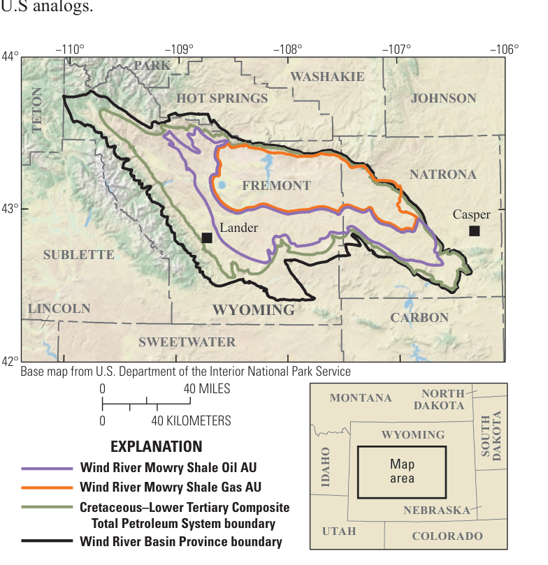
The two continuous assessment units in the Mowry Shale, Wind River Basin Province. Base map from the National Park Service; USGS.
The estimate
Using a geology-based method, the U.S. Geological Survey estimates the Mowry Shale in Wyoming's Wind River Basin Province holds undiscovered, technically recoverable continuous (unconventional) resources with mean totals of:
- 288 million barrels of oil (MMBO), with an F95–F5 range of 67 to 609 MMBO;
- 2,613 billion cubic feet of gas (BCFG) — 2.6 trillion cubic feet — range 575 to 5,799 BCFG;
- 11 million barrels of natural gas liquids (MMBNGL), range 2 to 23 MMBNGL.
F95 means a 95-percent chance of at least that amount; F5, a 5-percent chance.
The rock
In the Wind River Basin the Cretaceous Mowry has two units:
- a lower, soft, clay-rich shale;
- an upper siliceous part — dark gray to brown, organic-rich mudrock with many beds of siltstone, very fine sandstone and bentonite.
It was laid down in the northern arm of the Western Interior Seaway, a shallow inland sea that at times filled a long north–south basin east of the rising Cordilleran mountain belt. From the Late Cretaceous into the early Eocene, the Laramide orogeny broke that basin into smaller ones, including the Wind River Basin, flanked by rising basement-cored uplifts. They sank fast and filled with thick river and lake sediment from the latest Cretaceous to the middle Miocene.
Source and reservoir in one
The Mowry is part of the Cretaceous–Lower Tertiary Composite Total Petroleum System, and its upper siliceous part is both source and reservoir.
- Organic carbon: up to 5 weight percent — Type II kerogen with some mixed Type II/III, and hydrogen index values up to 531 milligrams of hydrocarbon per gram of organic carbon.
- Silica: up to 90 percent in potential reservoirs.
- Where: more organic-rich and oil-prone in the central and eastern basin.
- Maturity (vitrinite reflectance, Ro): mature for oil (0.6–1.35 percent Ro) along the western and southern margins, and for gas (above 1.35 percent) in the deeper central and northern basin. The shales matured during Laramide and later burial.
The model: oil and gas formed mainly during Laramide and later burial; some stayed in the Mowry after the rest moved into neighboring reservoirs.
Two assessment units
| Wind River Mowry Shale Oil AU | Wind River Mowry Shale Gas AU | |
|---|---|---|
| Where | the oil window (0.60–1.35 percent Ro) | where oil has cracked to gas (above 1.35 percent Ro) |
| Potential production area, mean | 591,600 acres | 656,167 acres |
| Well drainage area, mean | 106.7 acres | 120 acres |
| Success ratio, mean | 50% | 50% |
| Recovery per well, mean | 0.101 MMBO | 0.856 BCFG |
| AU probability | 1.0 | 1.0 |
Recovery per well is based on the Powder River Basin as a geologic analog, and on other U.S. analogs.
Results
Fully risked means:
| Assessment unit | Oil (MMBO) | Gas (BCFG) | NGL (MMBNGL) |
|---|---|---|---|
| Mowry Shale Oil | 288 | 288 | 9 |
| Mowry Shale Gas | — | 2,325 | 2 |
| Total | 288 | 2,613 | 11 |
More results are on the USGS Energy Resources Program website.
Sources
Based on Assessment of Continuous Oil and Gas Resources in the Mowry Shale, Wind River Basin Province, Wyoming, 2020, USGS Fact Sheet 2021–3006 (March 2021), by the Mowry Shale Assessment Team, U.S. Geological Survey; a work of the United States government in the public domain. The map and table figures are taken from the fact sheet's PDF.
许可协议: CC0 1.0(公有领域) · 改编自 pubs.usgs.gov
1
0
0
0

留言


