Download Image Download Hurricane Delta Image
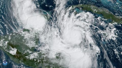
The GOES-East satellite tracked Hurricane Delta as it rapidly intensified from a tropical storm over the Caribbean Sea. As of 11:20 a.m. ET on Oct. 6, 2020, the storm’s maximum sustained wind speeds reached 130 mph, making it a major Category-4 hurricane on the Saffir-Simpson Hurricane Wind Scale, and it was expected to continue strengthening. According to the National Hurricane Center, an “extremely dangerous storm surge and hurricane conditions are expected over portions of the northern Yucatan Peninsula beginning tonight.”
After passing the peninsula, the storm was expected to swing up over the warm waters of the Gulf of Mexico and make landfall along the northern Gulf Coast—likely somewhere in Louisiana—by Friday or Saturday. Additionally, areas from Texas through the Florida panhandle were put on alert.
Note to screen-readers: This page is using an IFrame for the content-area, and you screen reader may not be abel to see it on this website.
For screen-reading purposes, please go directly to the IFrame's target page by going to
https://www.nesdis.noaa.gov/s3/migrated/20201006_deltalapse.mp4.
Delta is not only the earliest 25th named Atlantic storm on record; it is also the second time that the Greek letter Delta has been used to name a storm. The previous Delta storm formed on November 15, 2005. Additionally, if Delta makes landfall on the Gulf Coast, it will be the first time on record that 10 named storms have done so in the U.S. in one season, breaking the 1916 record of nine landfalling storms.
The GOES-East geostationary satellite, also known as GOES-16, keeps watch over most of North America, including the continental United States and Mexico, as well as Central and South America, the Caribbean, and the Atlantic Ocean to the west coast of Africa. The satellite's high-resolution imagery provides optimal viewing of severe weather events, including thunderstorms, tropical storms, and hurricanes.
Where this page came from
This page was imported from NOAA Satellites (NESDIS). Published by NOAA's National Environmental Satellite, Data, and Information Service and, as a work of the United States government, in the public domain; pictures credited elsewhere are left out.
Nobody has written it yet — it is the source material at a new address, which is why search engines are asked to skip it and why no one earns from it. It is up for grabs: take it on, and it is yours to rewrite and to earn from.
Licence: CC0 1.0 (public domain) · Adapted from www.nesdis.noaa.gov
1
0
0
0

Comments